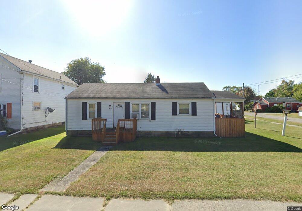
989 Bennett St Marion, OH 43302
Estimated Value: $86,000 - $108,000
2
Beds
1
Bath
944
Sq Ft
$105/Sq Ft
Est. Value
About This Home
This home is located at 989 Bennett St, Marion, OH 43302 and is currently estimated at $99,207, approximately $105 per square foot. 989 Bennett St is a home located in Marion County with nearby schools including James A. Garfield Elementary School, Ulysses S. Grant Middle School, and Harding High School.
Ownership History
Date
Name
Owned For
Owner Type
Purchase Details
Closed on
Jul 17, 2015
Sold by
Secretary Of Veterans Affairs
Bought by
Mcbride Gerald F
Current Estimated Value
Purchase Details
Closed on
May 5, 2015
Sold by
Williams Donna M and Williams Earl
Bought by
Secretary Of Veterans Affairs
Purchase Details
Closed on
Nov 19, 2003
Bought by
Mcbride Gerald F
Purchase Details
Closed on
Aug 28, 2003
Bought by
Mcbride Gerald F
Purchase Details
Closed on
Jul 22, 2003
Bought by
Mcbride Gerald F
Purchase Details
Closed on
May 2, 2003
Bought by
Mcbride Gerald F
Purchase Details
Closed on
Nov 14, 1997
Bought by
Mcbride Gerald F
Purchase Details
Closed on
Sep 28, 1994
Bought by
Mcbride Gerald F
Create a Home Valuation Report for This Property
The Home Valuation Report is an in-depth analysis detailing your home's value as well as a comparison with similar homes in the area
Home Values in the Area
Average Home Value in this Area
Purchase History
| Date | Buyer | Sale Price | Title Company |
|---|---|---|---|
| Mcbride Gerald F | -- | Attorney | |
| Secretary Of Veterans Affairs | $30,000 | Attorney | |
| Mcbride Gerald F | $63,000 | -- | |
| Mcbride Gerald F | -- | -- | |
| Mcbride Gerald F | $25,800 | -- | |
| Mcbride Gerald F | -- | -- | |
| Mcbride Gerald F | $28,000 | -- | |
| Mcbride Gerald F | $29,000 | -- |
Source: Public Records
Tax History
| Year | Tax Paid | Tax Assessment Tax Assessment Total Assessment is a certain percentage of the fair market value that is determined by local assessors to be the total taxable value of land and additions on the property. | Land | Improvement |
|---|---|---|---|---|
| 2025 | $842 | $27,100 | $3,020 | $24,080 |
| 2024 | $842 | $21,920 | $2,750 | $19,170 |
| 2023 | $842 | $21,920 | $2,750 | $19,170 |
| 2022 | $782 | $21,920 | $2,750 | $19,170 |
| 2021 | $778 | $19,660 | $2,390 | $17,270 |
| 2020 | $780 | $19,660 | $2,390 | $17,270 |
| 2019 | $759 | $19,660 | $2,390 | $17,270 |
| 2018 | $574 | $14,880 | $2,380 | $12,500 |
| 2017 | $582 | $14,880 | $2,380 | $12,500 |
| 2016 | $578 | $12,880 | $1,180 | $11,700 |
| 2015 | $514 | $12,600 | $1,120 | $11,480 |
| 2014 | $155 | $12,600 | $1,120 | $11,480 |
| 2013 | $153 | $12,600 | $1,120 | $11,480 |
| 2012 | $216 | $14,140 | $1,560 | $12,580 |
Source: Public Records
Map
Nearby Homes
Your Personal Tour Guide
Ask me questions while you tour the home.