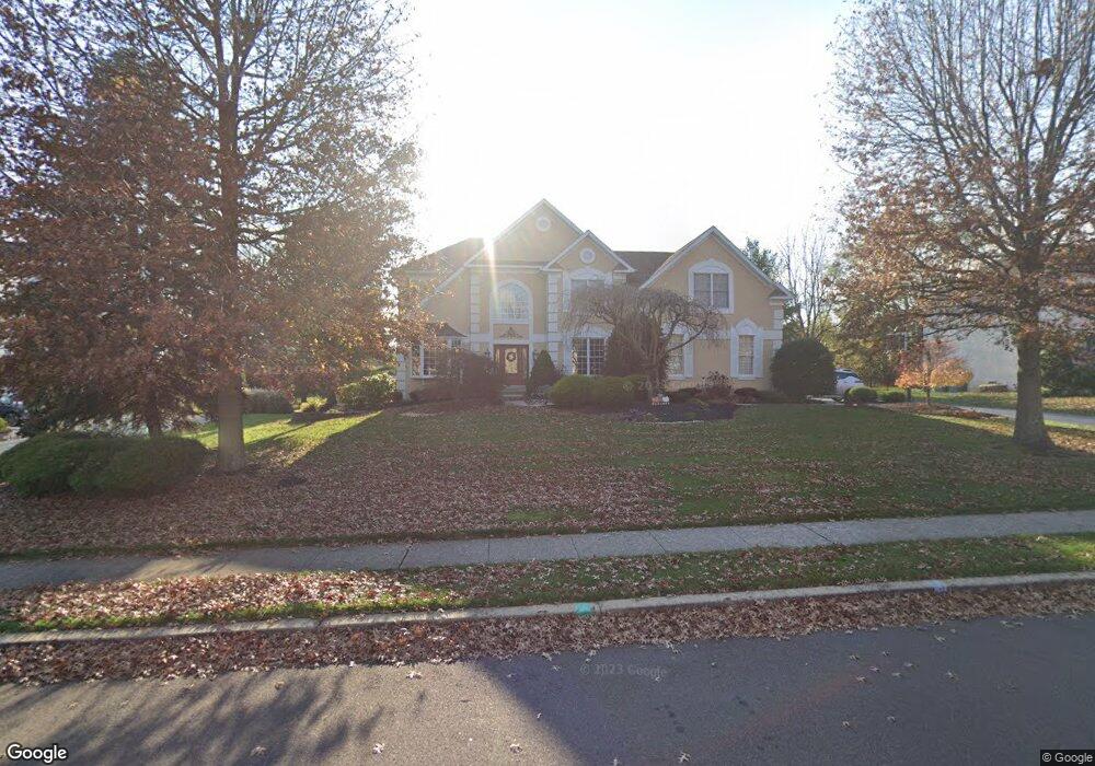
99 Addis Dr Southampton, PA 18966
Estimated Value: $1,090,980 - $1,292,000
5
Beds
5
Baths
5,757
Sq Ft
$208/Sq Ft
Est. Value
About This Home
This home is located at 99 Addis Dr, Southampton, PA 18966 and is currently estimated at $1,198,995, approximately $208 per square foot. 99 Addis Dr is a home located in Bucks County with nearby schools including Maureen M. Welch Elementary School, Richboro Middle School, and Council Rock High School - South.
Ownership History
Date
Name
Owned For
Owner Type
Purchase Details
Closed on
Sep 25, 2020
Sold by
Mackerchar Daniel A and Mackerchar Jennifer L
Bought by
Mackerchar Daniel A and Mackerchar Jennifer L
Current Estimated Value
Home Financials for this Owner
Home Financials are based on the most recent Mortgage that was taken out on this home.
Original Mortgage
$350,500
Outstanding Balance
$250,882
Interest Rate
2.71%
Mortgage Type
New Conventional
Estimated Equity
$948,113
Purchase Details
Closed on
Dec 27, 2001
Sold by
Toll Pa Lp
Bought by
Mackerchar Daniel A and Mackherchar Jennifer L
Home Financials for this Owner
Home Financials are based on the most recent Mortgage that was taken out on this home.
Original Mortgage
$503,750
Interest Rate
6.85%
Mortgage Type
Stand Alone First
Create a Home Valuation Report for This Property
The Home Valuation Report is an in-depth analysis detailing your home's value as well as a comparison with similar homes in the area
Home Values in the Area
Average Home Value in this Area
Purchase History
| Date | Buyer | Sale Price | Title Company |
|---|---|---|---|
| Mackerchar Daniel A | -- | Primary Abstract | |
| Mackerchar Daniel A | $504,167 | -- |
Source: Public Records
Mortgage History
| Date | Status | Borrower | Loan Amount |
|---|---|---|---|
| Open | Mackerchar Daniel A | $350,500 | |
| Previous Owner | Mackerchar Daniel A | $503,750 |
Source: Public Records
Tax History Compared to Growth
Tax History
| Year | Tax Paid | Tax Assessment Tax Assessment Total Assessment is a certain percentage of the fair market value that is determined by local assessors to be the total taxable value of land and additions on the property. | Land | Improvement |
|---|---|---|---|---|
| 2025 | $12,518 | $64,990 | $8,480 | $56,510 |
| 2024 | $12,518 | $64,990 | $8,480 | $56,510 |
| 2023 | $11,798 | $64,990 | $8,480 | $56,510 |
| 2022 | $11,690 | $64,990 | $8,480 | $56,510 |
| 2021 | $11,320 | $64,990 | $8,480 | $56,510 |
| 2020 | $11,065 | $64,990 | $8,480 | $56,510 |
| 2019 | $10,591 | $64,990 | $8,480 | $56,510 |
| 2018 | $10,403 | $64,990 | $8,480 | $56,510 |
| 2017 | $10,002 | $64,990 | $8,480 | $56,510 |
| 2016 | $10,002 | $64,990 | $8,480 | $56,510 |
| 2015 | -- | $64,990 | $8,480 | $56,510 |
| 2014 | -- | $64,990 | $8,480 | $56,510 |
Source: Public Records
Map
Nearby Homes
- 55 Mount Pleasant Dr
- 56 Joshua Dr
- 105 Edwards Dr
- 34 Acorn Dr
- 800 New Rd
- 18 Daffodil Dr
- 371 N 2nd Street Pike
- 23 Oxford Dr
- 61 Legacy Oaks Dr Unit 62
- 290 Hatboro Rd
- 3 Shady Pines Dr
- 55 W Windrose Dr
- 54 Legacy Oaks Dr Unit 94
- 8 Shady Pines Dr
- 47 Creek Rd
- 29 Devon Rd
- 223 Cecelia Acres Dr
- 249 New Rd
- 3 Tanyard Rd
- 208 Cecelia Acres Dr