
99 Land of Nod Rd Windham, ME 04062
Estimated payment $4,667/month
Highlights
- Nearby Water Access
- 1.84 Acre Lot
- Deck
- View of Trees or Woods
- Colonial Architecture
- Wooded Lot
About This Home
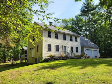
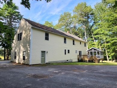
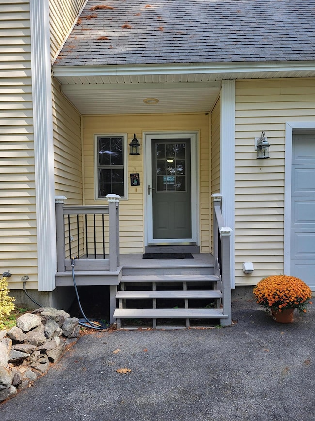
Move in ready & neat as a pin! A 'must see' on the list!...This 2003, custom built, well maintained, colonial home has been enjoyed by the same couple since it was built! Located in a pastoral, residential neighborhood setting yet close to shopping & services, in Windham & greater Portland. 20mins to turnpike access or hop onto nearby USrt302 to head to points west! The home offers 3 bedrooms, 2.5 baths, a ''front-to-back'' living
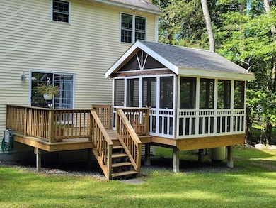
room, w/gas fireplace, front-to-back master bedroom w/master bath & walk-in closets, a dedicated office room, mudroom, screened
porch & huge bonus room above attached 2-car attached garage. Hardwood, tile & carpeted floors throughout with quality fixtures & granite
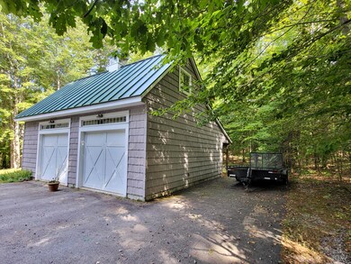
countertop. If you've got ''toys'', additional vehicles or need storage the custom outbldg. /3-bay garage +w/addtl. car-port area, on the rear, will be of
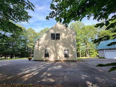
particular interest and ''can accommodate!'' This building might also offer rental income for storage of a boat or antique auto, if not needed. The lot is screened from the roadway by trees, offering privacy and the backyard can be enjoyed from using the deck or it's covered screened room or by sitting around the fire-pit. The lot has direct access to the PNG pipeline snowmobile trail from the backyard! Home Warranty available! Inventory is low...schedule a viewing today!
Listing Agent
Better Homes & Gardens Real Estate/The Masiello Group Listed on: 09/19/2025

Home Details
Home Type
- Single Family
Est. Annual Taxes
- $7,499
Year Built
- Built in 2003
Lot Details
- 1.84 Acre Lot
- Rural Setting
- Level Lot
- Wooded Lot
Parking
- 4 Car Direct Access Garage
- Carport
- Driveway
Home Design
- Colonial Architecture
- Concrete Foundation
- Wood Frame Construction
- Shingle Roof
- Vinyl Siding
- Concrete Perimeter Foundation
Interior Spaces
- 2,831 Sq Ft Home
- 1 Fireplace
- Mud Room
- Living Room
- Dining Room
- Screened Porch
- Views of Woods
Kitchen
- Gas Range
- Microwave
- Dishwasher
- Granite Countertops
- Formica Countertops
- Trash Compactor
Flooring
- Wood
- Carpet
- Tile
Bedrooms and Bathrooms
- 3 Bedrooms
- Primary bedroom located on second floor
- En-Suite Primary Bedroom
- Walk-In Closet
Laundry
- Laundry on upper level
- Dryer
- Washer
Unfinished Basement
- Basement Fills Entire Space Under The House
- Interior Basement Entry
Outdoor Features
- Nearby Water Access
- River Nearby
- Deck
- Outbuilding
Utilities
- Window Unit Cooling System
- Zoned Heating
- Heating System Uses Oil
- Heating System Uses Propane
- Baseboard Heating
- Hot Water Heating System
- Private Water Source
- Well
- Septic System
- Septic Design Available
- Private Sewer
Community Details
- No Home Owners Association
- Community Storage Space
Listing and Financial Details
- Tax Lot 14D-1
- Assessor Parcel Number WINM-000007-000014-D000001
Map
Home Values in the Area
Average Home Value in this Area
Tax History
| Year | Tax Paid | Tax Assessment Tax Assessment Total Assessment is a certain percentage of the fair market value that is determined by local assessors to be the total taxable value of land and additions on the property. | Land | Improvement |
|---|---|---|---|---|
| 2024 | $7,499 | $653,800 | $127,600 | $526,200 |
| 2023 | $6,981 | $623,300 | $118,700 | $504,600 |
| 2022 | $6,437 | $554,400 | $105,800 | $448,600 |
| 2021 | $5,887 | $467,200 | $92,100 | $375,100 |
| 2020 | $6,153 | $410,200 | $80,800 | $329,400 |
| 2019 | $6,005 | $410,200 | $80,800 | $329,400 |
| 2018 | $5,762 | $379,600 | $72,700 | $306,900 |
| 2017 | $5,887 | $358,300 | $64,600 | $293,700 |
| 2016 | $5,625 | $358,300 | $64,600 | $293,700 |
| 2015 | $5,428 | $358,300 | $64,600 | $293,700 |
| 2014 | $5,067 | $355,400 | $64,600 | $290,800 |
| 2013 | -- | $355,400 | $64,600 | $290,800 |
Property History
| Date | Event | Price | List to Sale | Price per Sq Ft |
|---|---|---|---|---|
| 11/02/2025 11/02/25 | Price Changed | $767,000 | -0.3% | $271 / Sq Ft |
| 10/12/2025 10/12/25 | Price Changed | $769,000 | -1.3% | $272 / Sq Ft |
| 09/27/2025 09/27/25 | Price Changed | $779,000 | -1.3% | $275 / Sq Ft |
| 09/19/2025 09/19/25 | For Sale | $789,500 | -- | $279 / Sq Ft |
Purchase History
| Date | Type | Sale Price | Title Company |
|---|---|---|---|
| Warranty Deed | -- | -- |
Mortgage History
| Date | Status | Loan Amount | Loan Type |
|---|---|---|---|
| Open | $155,550 | New Conventional |
Source: Maine Listings
MLS Number: 1637372
APN: WINM-000007-000014-D000001
Disclaimer: Certain information contained herein is derived from information provided by parties other than Homes.com. All information provided is deemed reliable, but is not guaranteed to be accurate and should be independently verified.
![]() Listing data is derived in whole or in part from Maine Real Estate Information System, Inc. (d/b/a Maine Listings) and is for consumers' personal, noncommercial use only. Dimensions are approximate and not guaranteed. All data should be independently verified.
Listing data is derived in whole or in part from Maine Real Estate Information System, Inc. (d/b/a Maine Listings) and is for consumers' personal, noncommercial use only. Dimensions are approximate and not guaranteed. All data should be independently verified.
© 2025 Maine Real Estate Information System, Inc. All Rights Reserved. Equal Housing Opportunity.
Homes.com, LLC, 17600 Laguna Canyon Rd Irvine, CA 92618 (888)-952-6393
![]()
- 23 Land of Nod Rd
- 18 Marshall Valley Rd
- 30 Marshall Valley Rd
- 163A Highland Cliff Rd
- 166A Highland Cliff Rd
- 1 Daybreak Ln Unit 1
- 7 Daybreak Ln Unit 3
- 25 Driftwood Ln Unit 19
- 23 Daybreak Ln Unit 23
- 18 Daybreak Ln Unit 13
- 4 Daybreak Ln Unit 19
- 22 Daybreak Ln Unit 11
- 9 Haven Rd
- 11 Haven Rd
- 29 Montgomery Rd
- 289 Highland Cliff Rd
- 12 Merrill Rd
- 10/1/B01 Chute Rd
- 5 Betty Ln
- 14 Betty Ln
- 6 Stockyard Dr
- 9 Gambo Rd
- 9 Gambo Rd
- 37 Brentwood Rd Unit ID1255706P
- 712 Gray Rd
- 1 Ari Dr
- 21 Mill Rd Unit 2
- 723 Riverside St
- 30 Pierce St Unit A
- 36 King St Unit 2F
- 3 Austrian Way Unit Tranquility Found
- 2 New Gorham Rd Unit 2
- 762 Main St Unit 1
- 1619 Washington Ave
- 84 Johnson Rd Unit Main
- 280 Main St Unit 2
- 39 W Pleasant St
- 69 Maggie Ln
- 345 Saco St Unit 23
- 10 White Birch Ln