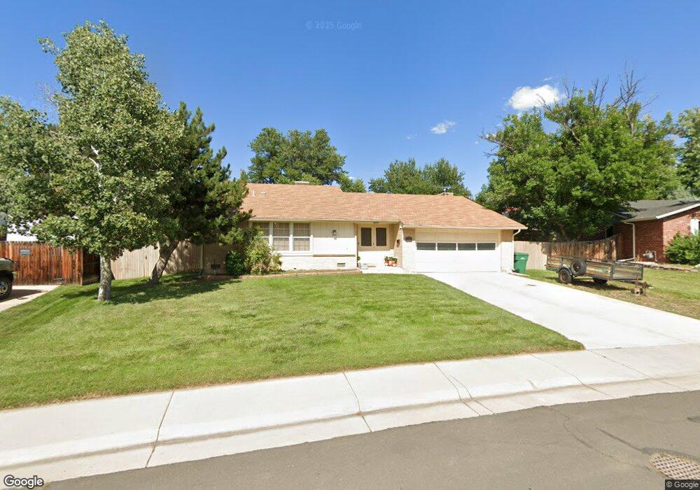
990 Flint Way Broomfield, CO 80020
Broomfield Heights NeighborhoodEstimated Value: $570,000 - $645,000
4
Beds
2
Baths
2,065
Sq Ft
$289/Sq Ft
Est. Value
About This Home
This home is located at 990 Flint Way, Broomfield, CO 80020 and is currently estimated at $596,291, approximately $288 per square foot. 990 Flint Way is a home located in Broomfield County with nearby schools including Kohl Elementary School, Broomfield Heights Middle School, and Broomfield High School.
Ownership History
Date
Name
Owned For
Owner Type
Purchase Details
Closed on
Jul 26, 2007
Sold by
Ryan Chris R
Bought by
Spoelstra Andrew J and Spoelstra Sarah B
Current Estimated Value
Home Financials for this Owner
Home Financials are based on the most recent Mortgage that was taken out on this home.
Original Mortgage
$231,369
Outstanding Balance
$147,015
Interest Rate
6.73%
Mortgage Type
FHA
Estimated Equity
$449,276
Purchase Details
Closed on
Apr 4, 2000
Purchase Details
Closed on
Sep 8, 1995
Purchase Details
Closed on
Jul 16, 1973
Create a Home Valuation Report for This Property
The Home Valuation Report is an in-depth analysis detailing your home's value as well as a comparison with similar homes in the area
Home Values in the Area
Average Home Value in this Area
Purchase History
| Date | Buyer | Sale Price | Title Company |
|---|---|---|---|
| Spoelstra Andrew J | $235,000 | Title America | |
| -- | $194,000 | -- | |
| -- | $140,200 | -- | |
| -- | $35,900 | -- |
Source: Public Records
Mortgage History
| Date | Status | Borrower | Loan Amount |
|---|---|---|---|
| Open | Spoelstra Andrew J | $231,369 |
Source: Public Records
Tax History Compared to Growth
Tax History
| Year | Tax Paid | Tax Assessment Tax Assessment Total Assessment is a certain percentage of the fair market value that is determined by local assessors to be the total taxable value of land and additions on the property. | Land | Improvement |
|---|---|---|---|---|
| 2025 | $3,481 | $38,430 | $9,050 | $29,380 |
| 2024 | $3,481 | $37,150 | $8,230 | $28,920 |
| 2023 | $3,474 | $42,350 | $9,380 | $32,970 |
| 2022 | $2,891 | $29,900 | $6,600 | $23,300 |
| 2021 | $2,877 | $30,770 | $6,790 | $23,980 |
| 2020 | $2,879 | $30,600 | $6,080 | $24,520 |
| 2019 | $2,873 | $30,820 | $6,120 | $24,700 |
| 2018 | $2,483 | $26,310 | $4,570 | $21,740 |
| 2017 | $2,446 | $29,080 | $5,050 | $24,030 |
| 2016 | $2,060 | $21,850 | $5,050 | $16,800 |
| 2015 | $1,989 | $16,720 | $5,050 | $11,670 |
| 2014 | $1,556 | $16,720 | $5,050 | $11,670 |
Source: Public Records
Map
Nearby Homes
- 870 Hemlock Way
- 685 Daphne St
- 1320 Holly Dr E
- 400 W Midway Blvd
- 1148 Opal St Unit 101
- 1176 Opal St Unit 102
- 640 Kalmia Way
- 1150 Opal St Unit 101
- 1330 Iris Cir
- 1305 Laurel St
- 1190 Opal St Unit 104
- 1320 W 12th Ave
- 1118 Oakhurst Dr
- 57 Scott Dr S
- 639 Quartz Way
- 1606 Iris St
- 37 E 14th Place
- 114 E 14th Ct
- 2191 Ridge Dr
- 51 Douglas Dr S