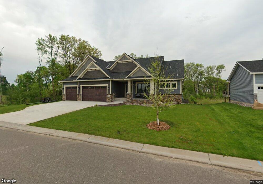
990 Pheasant Run S Circle Pines, MN 55014
Estimated Value: $677,000 - $788,000
3
Beds
3
Baths
3,728
Sq Ft
$201/Sq Ft
Est. Value
About This Home
This home is located at 990 Pheasant Run S, Circle Pines, MN 55014 and is currently estimated at $748,779, approximately $200 per square foot. 990 Pheasant Run S is a home located in Anoka County with nearby schools including Rice Lake Elementary School, Centennial Middle School, and Centennial High School.
Ownership History
Date
Name
Owned For
Owner Type
Purchase Details
Closed on
May 21, 2019
Sold by
Lang Builders Inc
Bought by
Espinosa Nathan P and Espinosa Amber N
Current Estimated Value
Home Financials for this Owner
Home Financials are based on the most recent Mortgage that was taken out on this home.
Original Mortgage
$546,000
Outstanding Balance
$479,069
Interest Rate
4.1%
Mortgage Type
New Conventional
Estimated Equity
$269,710
Purchase Details
Closed on
Dec 8, 2017
Sold by
Royal Oaks Reatlty Inc
Bought by
Lang Builders Inc
Create a Home Valuation Report for This Property
The Home Valuation Report is an in-depth analysis detailing your home's value as well as a comparison with similar homes in the area
Home Values in the Area
Average Home Value in this Area
Purchase History
| Date | Buyer | Sale Price | Title Company |
|---|---|---|---|
| Espinosa Nathan P | $682,500 | Results Title | |
| Lang Builders Inc | $119,900 | First American Title Insruan | |
| Roya Oaks Realty Inc | -- | First American Title |
Source: Public Records
Mortgage History
| Date | Status | Borrower | Loan Amount |
|---|---|---|---|
| Open | Espinosa Nathan P | $546,000 |
Source: Public Records
Tax History
| Year | Tax Paid | Tax Assessment Tax Assessment Total Assessment is a certain percentage of the fair market value that is determined by local assessors to be the total taxable value of land and additions on the property. | Land | Improvement |
|---|---|---|---|---|
| 2025 | $8,903 | $749,900 | $193,200 | $556,700 |
| 2024 | $8,903 | $702,100 | $157,000 | $545,100 |
| 2023 | $7,833 | $705,800 | $138,500 | $567,300 |
| 2022 | $7,880 | $673,500 | $129,500 | $544,000 |
| 2021 | $7,681 | $591,300 | $115,500 | $475,800 |
| 2020 | $7,584 | $564,900 | $115,500 | $449,400 |
| 2019 | $2,209 | $541,900 | $119,700 | $422,200 |
| 2018 | $1,652 | $126,000 | $0 | $0 |
| 2017 | $1,043 | $132,300 | $0 | $0 |
Source: Public Records
Map
Nearby Homes
- 965 Pheasant Run S
- 6478 Fox Rd
- 922 Pheasant Run S
- 907 Fox Rd
- 1063 Aspen Ln
- 6559 Black Duck Dr S
- 849 Fox Cove
- 1150 Durango Point
- 6657 White Birch Ct
- 1241 Holly Dr E
- 1205 Choke Cherry Rd
- 749 Fox Rd
- 1229 Choke Cherry Rd
- 6323 Red Maple Ln
- 6326 White Owl Dr
- 1295 Velvetleaf Ln
- 6766 E Shadow Lake Dr
- 553 Hawthorn Rd
- 6824 W Shadow Lake Dr
- 1415 Sherman Lake Rd
- 986 Pheasant Run S
- 1006 Pheasant Run S
- 6442 Black Berry Ct
- 6434 Black Berry Ct
- 1013 Pheasant Run S
- 6426 Black Berry Ct
- 1014 Pheasant Run S
- 985 Pheasant Run S
- 1019 Pheasant Run S
- 6405 Black Berry Ct
- 1022 Pheasant Run S
- 6449 Black Berry Ct
- 981 Pheasant Run S
- 6402 Black Berry Ct
- 6445 Black Berry Ct
- 6441 Black Berry Ct
- 6452 Killdeer Dr
- 6431 Black Berry Ct
- 6465 Killdeer Dr
- 6425 Blackberry Ct
Your Personal Tour Guide
Ask me questions while you tour the home.