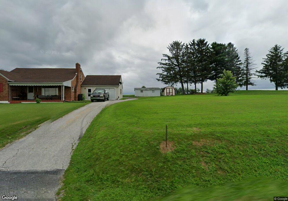
9901 Winterstown Rd Red Lion, PA 17356
Estimated Value: $272,507 - $352,000
3
Beds
1
Bath
1,383
Sq Ft
$218/Sq Ft
Est. Value
About This Home
This home is located at 9901 Winterstown Rd, Red Lion, PA 17356 and is currently estimated at $301,627, approximately $218 per square foot. 9901 Winterstown Rd is a home located in York County with nearby schools including North Hopewell-Winterstown Elementary School, Red Lion Area Junior High School, and Red Lion Area Senior High School.
Ownership History
Date
Name
Owned For
Owner Type
Purchase Details
Closed on
Jun 27, 2008
Sold by
Frey Darlene M and Young Wilbur E
Bought by
Troop Brian A and Troop Beverly A
Current Estimated Value
Home Financials for this Owner
Home Financials are based on the most recent Mortgage that was taken out on this home.
Original Mortgage
$132,000
Outstanding Balance
$85,157
Interest Rate
6.07%
Mortgage Type
Purchase Money Mortgage
Estimated Equity
$216,470
Create a Home Valuation Report for This Property
The Home Valuation Report is an in-depth analysis detailing your home's value as well as a comparison with similar homes in the area
Home Values in the Area
Average Home Value in this Area
Purchase History
| Date | Buyer | Sale Price | Title Company |
|---|---|---|---|
| Troop Brian A | $169,000 | None Available |
Source: Public Records
Mortgage History
| Date | Status | Borrower | Loan Amount |
|---|---|---|---|
| Open | Troop Brian A | $132,000 |
Source: Public Records
Tax History Compared to Growth
Tax History
| Year | Tax Paid | Tax Assessment Tax Assessment Total Assessment is a certain percentage of the fair market value that is determined by local assessors to be the total taxable value of land and additions on the property. | Land | Improvement |
|---|---|---|---|---|
| 2025 | $4,347 | $137,960 | $43,910 | $94,050 |
| 2024 | $4,212 | $137,960 | $43,910 | $94,050 |
| 2023 | $4,212 | $137,960 | $43,910 | $94,050 |
| 2022 | $4,212 | $137,960 | $43,910 | $94,050 |
| 2021 | $4,074 | $137,960 | $43,910 | $94,050 |
| 2020 | $4,074 | $137,960 | $43,910 | $94,050 |
| 2019 | $4,060 | $137,960 | $43,910 | $94,050 |
| 2018 | $4,060 | $137,960 | $43,910 | $94,050 |
| 2017 | $4,060 | $137,960 | $43,910 | $94,050 |
| 2016 | $0 | $137,960 | $43,910 | $94,050 |
| 2015 | -- | $137,960 | $43,910 | $94,050 |
| 2014 | -- | $137,960 | $43,910 | $94,050 |
Source: Public Records
Map
Nearby Homes
- 661 S Duke St
- 600 S Duke St
- 420 Greenway Dr
- 9353 Camp Rd
- 460 Highland Rd
- 786 Arbor Dr
- 211 Country Ridge Dr
- 131 Country Club Rd
- 168 Country Ridge Dr
- 156 Country Ridge Dr
- 260 Country Ridge Dr
- 131 Country Ridge Dr
- 126 Country Ridge Dr
- 738 Wise Ave
- 840 Country Club Rd
- 126 Linden Ave
- 305 Husson Rd
- 503 W Broadway
- 321 Atlantic Ave
- 338 Atlantic Ave
- 9873 Winterstown Rd
- 9935 Winterstown Rd
- 9855 Winterstown Rd
- 9959 Winterstown Rd
- 9987 Winterstown Rd
- 10013 Winterstown Rd
- 675 Winterstown Rd
- 760 Winterstown Rd
- 40 Sinclair Rd
- 20 Sinclair Rd
- 10068 Sinclair Rd
- 70 Sinclair Rd
- 12 Sinclair Rd
- 80 Sinclair Rd
- 90 Sinclair Rd
- 710 Winterstown Rd
- 8829 Park St
- 4780 Herbst Rd
- 670 Winterstown Rd
- 886 S Park St