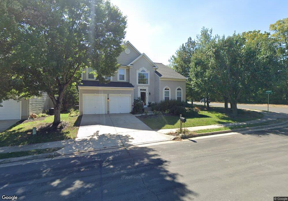
9917 Upper Mill Loop Bristow, VA 20136
Villages At Saybrooke NeighborhoodEstimated Value: $757,054 - $808,000
4
Beds
4
Baths
2,651
Sq Ft
$295/Sq Ft
Est. Value
About This Home
This home is located at 9917 Upper Mill Loop, Bristow, VA 20136 and is currently estimated at $783,014, approximately $295 per square foot. 9917 Upper Mill Loop is a home located in Prince William County with nearby schools including Patriot High School, Cedar Point Elementary School, and E.H. Marsteller Middle School.
Ownership History
Date
Name
Owned For
Owner Type
Purchase Details
Closed on
Dec 29, 2000
Sold by
The Ryland Group Inc
Bought by
Lewis Kendall B
Current Estimated Value
Home Financials for this Owner
Home Financials are based on the most recent Mortgage that was taken out on this home.
Original Mortgage
$282,850
Outstanding Balance
$105,497
Interest Rate
7.69%
Estimated Equity
$677,517
Create a Home Valuation Report for This Property
The Home Valuation Report is an in-depth analysis detailing your home's value as well as a comparison with similar homes in the area
Home Values in the Area
Average Home Value in this Area
Purchase History
| Date | Buyer | Sale Price | Title Company |
|---|---|---|---|
| Lewis Kendall B | $297,770 | -- |
Source: Public Records
Mortgage History
| Date | Status | Borrower | Loan Amount |
|---|---|---|---|
| Open | Lewis Kendall B | $282,850 |
Source: Public Records
Tax History
| Year | Tax Paid | Tax Assessment Tax Assessment Total Assessment is a certain percentage of the fair market value that is determined by local assessors to be the total taxable value of land and additions on the property. | Land | Improvement |
|---|---|---|---|---|
| 2025 | $6,555 | $709,200 | $205,000 | $504,200 |
| 2024 | $6,555 | $659,100 | $195,100 | $464,000 |
| 2023 | $6,490 | $623,700 | $174,800 | $448,900 |
| 2022 | $6,608 | $586,400 | $155,400 | $431,000 |
| 2021 | $6,253 | $513,000 | $142,800 | $370,200 |
| 2020 | $7,167 | $462,400 | $127,300 | $335,100 |
| 2019 | $7,130 | $460,000 | $127,300 | $332,700 |
| 2018 | $5,285 | $437,700 | $121,200 | $316,500 |
| 2017 | $5,350 | $434,300 | $121,200 | $313,100 |
| 2016 | $5,032 | $411,900 | $109,300 | $302,600 |
| 2015 | $4,762 | $404,700 | $109,300 | $295,400 |
| 2014 | $4,762 | $381,100 | $104,200 | $276,900 |
Source: Public Records
Map
Nearby Homes
- 9813 Nugget Ct
- 12044 Vantage Point Ct
- 11821 Arcari Dr
- 12149 Drum Salute Place
- 12217 Wheat Mill Loop
- 9322 Falling Water Dr
- 10116 Middlebrooks Terrace
- 11863 Benton Lake Rd
- 9651 Culloden Ct
- 12360 Corncrib Ct
- 11770 Lake Baldwin Dr
- 9239 Dawkins Crest Cir
- 12511 Heykens Ln
- 12268 Sedge St
- 12504 Cavalier Forest Ct
- 12172 Aster Rd
- 10052 Naughton Ct
- 12203 Aster Rd
- 12566 Moray Firth Way
- 9092 Ribbon Falls Loop
- 9907 Upper Mill Loop
- 11981 Youngtree Ct
- 9909 Upper Mill Loop
- 11980 Youngtree Ct
- 11985 Youngtree Ct
- 9743 Faber Ln
- 9915 Upper Mill Loop
- 9741 Faber Ln
- 9739 Faber Ln
- 12058 Etta Place
- 12056 Etta Place
- 12060 Etta Place
- 12062 Etta Place
- 12054 Etta Place
- 11990 Youngtree Ct
- 9737 Faber Ln
- 12052 Etta Place
- 12064 Etta Place
- 12050 Etta Place
- 11989 Youngtree Ct
Your Personal Tour Guide
Ask me questions while you tour the home.