NOT LISTED FOR SALE

L5 B4 Parsons Rd Driggs, ID 83422

Estimated Value: $1,147,000 - $1,491,395

6 Acres
$225,778 Price per Acre
245,243 Sq Ft Lot

Last Sold July 15, 2020

Current estimated payment $7,425/month

About This Lot

As of July 2020

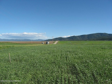
Rock-free topsoil and water rights in the foothills of the Big Hole Range, 5.5 miles west of Driggs on Bates(Ski Hill) Road. Entire subdivision is currently farmed, which manages noxious weeds, supplements HOA, and keeps property taxes in agriculture. Excellent horse property. Listing agent is part-owner of property.

Last Agent to Sell the Property

Matt Hail

eXp Realty, LLC License #SP37399 Listed on: 06/16/2020

eXp Realty, LLC

Last Buyer's Agent

Matt Hail

Coldwell Banker Mountain Properties License #SP37399

Property Details

Property Type

  • Land

Est. Annual Taxes

  • $3,804

Year Built

  • 2022

Lot Details

  • 5.63

Additional Features

  • 5.63 Acre Lot
  • Horses Allowed On Property

Community Details

  • Property has a Home Owners Association
  • Blue Indian Subdivision

Listing and Financial Details

  • Tax Lot Lot 5, Block 4
  • Assessor Parcel Number RP008950040050

Property Details

Property Type

Land

Est. Annual Taxes

$3,804

Year Built

2022

Lot Details

0

Listing Details

  • Prop. Type: Building Site
  • Horses: Yes
  • Lot Size Acres: 5.63
  • Subdivision Name: Blue Indian
  • Directions: From Driggs, go west on Bates road for 5.5 miles to 6000 West, then turn north. Property on west side of road.
  • Property Info:Horses Allowed: Yes
  • Property Info:_pound_ Horses Allowed: 4
  • Sale Status:Potential Short Sale: No
  • Special Features: None
  • Property Sub Type: LotsLands
  • Year Built (Public Record): 2022

Exterior Features

  • Lot Features: ST Rental Allowed, Modular Allowed

Utilities

  • Sewer: Septic Needed
  • Water Source: Well (not existing)

Condo/Co-op/Association

  • Association Fee: 150.0
  • Association: Yes

Lot Info

  • Lot Size Sq Ft: 245242.8
  • Parcel #: RP008950040050
  • Zoning Description: Single Family
  • ResoLotSizeUnits: Acres

Tax Info

  • Tax Annual Amount: 24.0
  • Tax Lot: Lot 5, Block 4
  • Tax Year: 2019

Ownership History

Date Name Owned For Owner Type

Purchase Details

Closed on
Feb 12, 2025
Sold by
Wilderness Property Management Llc
Bought by
Devries Corey and Heather Joy De Vries
Total Days on Market
0
Current Estimated Value
$1,271,132

Home Financials for this Owner

Home Financials are based on the most recent Mortgage that was taken out on this home.
Original Mortgage
$1,330,500
Outstanding Balance
$1,328,273
Interest Rate
6.91%
Mortgage Type
Credit Line Revolving
Estimated Equity
-$97,302

Purchase Details

Listed on
Jun 16, 2020
Closed on
Jul 10, 2020
Sold by
Buxton West Llc
Bought by
Wilderness Property Management Llc
Seller's Agent
Matt Hail
eXp Realty, LLC
Buyer's Agent
Matt Hail
Coldwell Banker Mountain Properties
List Price
$95,000
Sold Price
$90,000
Premium/Discount to List
-$5,000
-5.26%

Home Financials for this Owner

Home Financials are based on the most recent Mortgage that was taken out on this home.
Avg. Annual Appreciation
70.36%
Original Mortgage
$72,000
Interest Rate
3.1%
Mortgage Type
New Conventional
Source: Public Records

Range of Values:

Collateral Analytics

Collateral Analytics Collateral Analytics AVMs (Automated Valuation Model) employ a number of statistical approaches combined with neighborhood-specific comparable selection guarantees the most up-to-date and precise valuations.

Not Available

Collateral Analytics does not have data for the current month. Please view the chart for historical values.

ICE

ICE Mortgage Technology ICE Mortgage Technology’s AVM (Automated Valuation Model) is a state-of-the-art online residential property valuation tool that provides a quick and accurate estimate of the value of almost any home in the U.S.

Not Available

ICE Mortgage Technology does not have data for the current month. Please view the chart for historical values.

First American

First American First American Data & Analytics’ next-generation AVM combines unrivaled data assets with a blended ensemble of valuation models to produce highly accurate, reliable valuations you can trust.

Not Available

First American does not have data for the current month. Please view the chart for historical values.

Quantarium

Quantarium Quantarium’s valuation service, repeatedly proven the industry’s most accurate and comprehensive, is supercharged with a self-learning and auto-tuning AI engine that continually becomes smarter and more accurate as it processes daily inputs from the industry’s leading RE data lake.

Not Available

Quantarium does not have data for the current month. Please view the chart for historical values.

Average Value
Not Available
List Price
Sold Price
Create a Home Valuation Report for This Property
The Home Valuation Report is an in-depth analysis detailing your home's value as well as a comparison with similar homes in the area

Home Values in the Area

Source: Public Records

Average Home Value in this Area


Source: Public Records

Purchase History

Date Buyer Sale Price Title Company
Devries Corey -- None Listed On Document
Wilderness Property Management Llc -- First American Title Driggs
Source: Public Records

Mortgage History

Date Status Borrower Loan Amount
Open Devries Corey $1,330,500
Previous Owner Wilderness Property Management Llc $72,000
Source: Public Records

Property History

Date Event Price Change Sq Ft Price
07/15/2020 07/15/20 Sold -- -- --
06/17/2020 06/17/20 Pending -- -- --
06/16/2020 06/16/20 For Sale $95,000 -- --
Source: Teton Board of REALTORS®

Tax History Compared to Growth

Source: Public Records

Tax History

Year Tax Paid Tax Assessment Tax Assessment Total Assessment is a certain percentage of the fair market value that is determined by local assessors to be the total taxable value of land and additions on the property. Land Improvement
2024 $3,804 $1,107,139 $185,790 $921,349
2023 $3,804 $983,132 $61,783 $921,349
2022 $107 $2,016 $2,016 $0
2021 $626 $95,710 $95,710 $0
2020 $24 $3,294 $3,294 $0
2019 $24 $3,294 $3,294 $0
2018 $25 $3,164 $3,164 $0
2017 $22 $3,074 $3,074 $0
2016 $36 $2,984 $2,984 $0
2015 $82 $2,849 $2,849 $0
Source: Public Records

Agents Affiliated with this Home

  • Section Image
See All Agents

Map

Source: Teton Board of REALTORS®

MLS Number: 20-1473

APN: RP008950040050