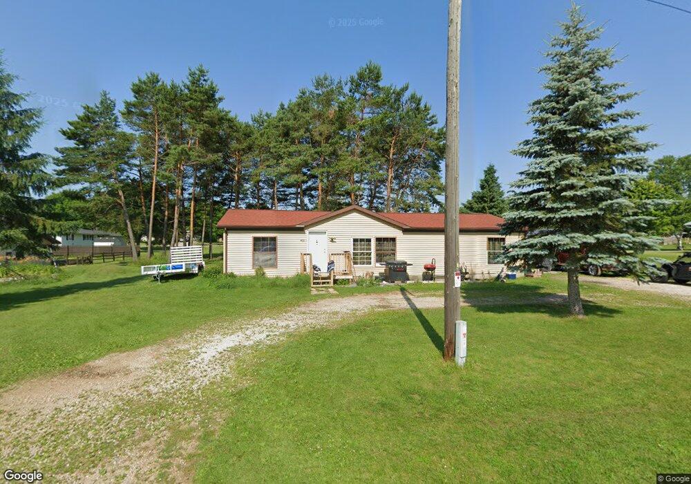
N121 Maple St Stephenson, MI 49887
Estimated Value: $163,000 - $214,000
3
Beds
2
Baths
1,352
Sq Ft
$137/Sq Ft
Est. Value
About This Home
This home is located at N121 Maple St, Stephenson, MI 49887 and is currently estimated at $185,555, approximately $137 per square foot. N121 Maple St is a home with nearby schools including Stephenson High School and Uplift Michigan Online School.
Ownership History
Date
Name
Owned For
Owner Type
Purchase Details
Closed on
Jun 12, 2014
Sold by
Rangel Arturo and Rangel Mercedes
Bought by
Rangel Arturo and Rangel Mercedes
Current Estimated Value
Purchase Details
Closed on
May 9, 2014
Sold by
Us Bank National Association
Bought by
Rangel Arturo and Rangel Mercedes
Purchase Details
Closed on
May 10, 2013
Sold by
Seaton Alice J and Seaton Stutzenberger
Purchase Details
Closed on
Dec 1, 1994
Sold by
Seaton Alice J
Bought by
Seaton Alice J and Seaton Stutzenberger G
Create a Home Valuation Report for This Property
The Home Valuation Report is an in-depth analysis detailing your home's value as well as a comparison with similar homes in the area
Purchase History
| Date | Buyer | Sale Price | Title Company |
|---|---|---|---|
| Rangel Arturo | -- | -- | |
| Rangel Arturo | -- | -- | |
| -- | $45,800 | -- | |
| Seaton Alice J | $100 | -- |
Source: Public Records
Tax History
| Year | Tax Paid | Tax Assessment Tax Assessment Total Assessment is a certain percentage of the fair market value that is determined by local assessors to be the total taxable value of land and additions on the property. | Land | Improvement |
|---|---|---|---|---|
| 2025 | $1,554 | $59,900 | $6,000 | $53,900 |
| 2024 | $1,372 | $53,200 | $6,000 | $47,200 |
| 2023 | $303 | $51,400 | $51,400 | $0 |
| 2022 | $1,306 | $51,400 | $51,400 | $0 |
| 2021 | $1,261 | $43,500 | $43,500 | $0 |
| 2020 | $303 | $40,500 | $0 | $0 |
| 2019 | $1,124 | $39,100 | $0 | $0 |
| 2018 | $1,157 | $38,500 | $38,500 | $0 |
| 2017 | -- | $39,200 | $39,200 | $0 |
| 2016 | -- | $38,500 | $0 | $0 |
| 2015 | -- | $38,500 | $0 | $0 |
| 2014 | -- | $39,200 | $39,200 | $0 |
| 2013 | -- | $39,800 | $0 | $0 |
Source: Public Records
Map
Nearby Homes
- E807 Gerue St
- W624 Division St
- 402 South Dr
- S327 Section St
- N9035 Gustafson Rd
- N9264 U S 41
- TBD M35
- N9615 Badish Rd
- 0 Kay Dr K1 Dr
- N9578 Lance Rd
- Lt43 Menominee Woods Dr
- N6403 County Road 577
- 0 Menominee Shores Dr Unit 50309184
- 0 Menominee Shores Dr Unit 50313854
- W6285 Co G-08 Rd
- 0 County Road 356
- 10896 County Road 356
- N11217 Rademaker Rd
- N11169 Rademaker Rd
- N11798 Old Us41 Hwy
- N127 Maple St
- 115 Maple St
- N126 Thoune St
- N117 Thoune St
- N111 Thoune St
- N105 Thoune St
- E807 Gerue St Unit E807
- E717 Gerue St
- E711 Gerue St
- E705 Gerue St
- E816 Gerue St Unit 14
- E718 Gerue St
- E710 Gerue St
- E702 Gerue St
- N120 Lynch St
- N104 Lynch St
- N128 Lynch St
- N136 Lynch St
- N113 Lynch St
- N113 Lynch St
Your Personal Tour Guide
Ask me questions while you tour the home.