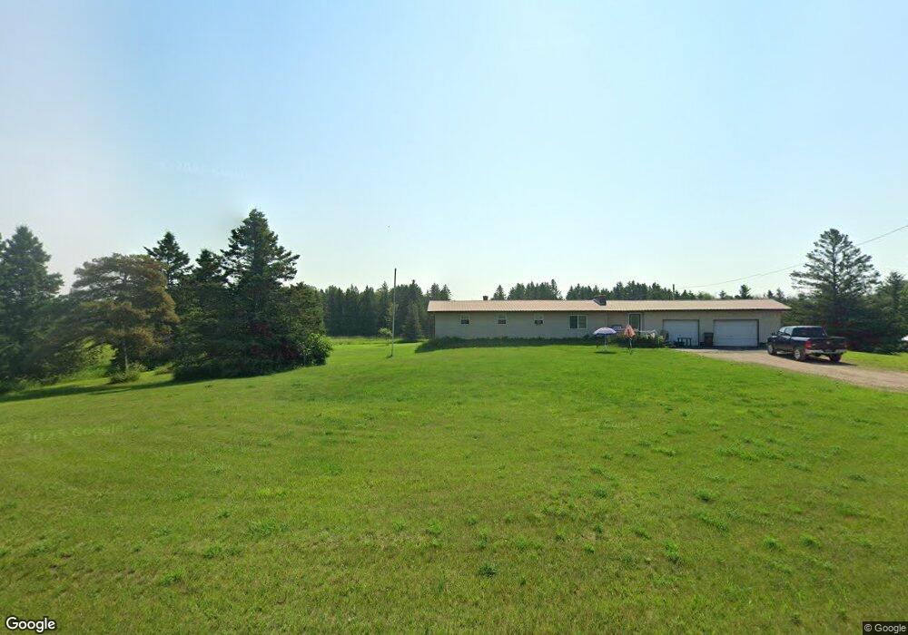
N15546 D 1 Rd Wilson, MI 49896
Estimated Value: $235,000 - $321,000
3
Beds
2
Baths
1,963
Sq Ft
$139/Sq Ft
Est. Value
About This Home
This home is located at N15546 D 1 Rd, Wilson, MI 49896 and is currently estimated at $272,687, approximately $138 per square foot. N15546 D 1 Rd is a home located in Menominee County with nearby schools including Bark River-Harris Elementary School and Bark River-Harris Jr/Sr High School.
Ownership History
Date
Name
Owned For
Owner Type
Purchase Details
Closed on
Sep 24, 2012
Sold by
Jpmorgan Chase Bank
Bought by
Gagne Adam Christopher
Current Estimated Value
Purchase Details
Closed on
Nov 9, 2011
Sold by
Jpmorgan Chase Bank Nat'L Assoc
Purchase Details
Closed on
Sep 2, 2011
Sold by
Thorsen David and Thorsen Jessica
Purchase Details
Closed on
Dec 29, 2008
Sold by
Knull Douglas and Knull Tammy
Bought by
Thorsen David and Thorsen Jessica
Purchase Details
Closed on
Nov 2, 2007
Sold by
Knull Douglas and Cibert Tammy
Bought by
Thorsen David and Thorsen Jessica
Purchase Details
Closed on
Jul 1, 2003
Sold by
Goudreau Joseph D and Patti Ann
Bought by
Knull Douglas and Cibert Tammy
Create a Home Valuation Report for This Property
The Home Valuation Report is an in-depth analysis detailing your home's value as well as a comparison with similar homes in the area
Purchase History
| Date | Buyer | Sale Price | Title Company |
|---|---|---|---|
| Gagne Adam Christopher | $42,000 | -- | |
| -- | -- | -- | |
| -- | $60,400 | -- | |
| Thorsen David | -- | -- | |
| Thorsen David | $114,400 | -- | |
| Knull Douglas | $103,000 | -- |
Source: Public Records
Tax History
| Year | Tax Paid | Tax Assessment Tax Assessment Total Assessment is a certain percentage of the fair market value that is determined by local assessors to be the total taxable value of land and additions on the property. | Land | Improvement |
|---|---|---|---|---|
| 2025 | $1,799 | $111,100 | $7,500 | $103,600 |
| 2024 | $1,613 | $98,900 | $10,000 | $88,900 |
| 2023 | $577 | $78,173 | $78,173 | $0 |
| 2020 | $577 | $74,459 | $0 | $0 |
| 2019 | -- | $74,471 | $0 | $0 |
| 2018 | -- | $69,776 | $69,776 | $0 |
| 2017 | -- | $70,192 | $70,192 | $0 |
| 2016 | -- | $67,861 | $0 | $0 |
| 2015 | -- | $67,861 | $0 | $0 |
| 2014 | -- | $57,703 | $57,703 | $0 |
| 2013 | $577 | $57,703 | $0 | $0 |
Source: Public Records
Map
Nearby Homes
- N16246 Co 557 Rd
- 3143 D Rd
- W6349 Greenwood Ave
- W3657 Greenwood Ave
- TBD E Labelle Rd
- W3751 Oak Ave
- TBD Cr 400 Parcel B Rd
- W715 Rd
- W2813 3-1 Ln
- 1070 Michigan 35
- V/L I Rd
- 0 County 366 Rd Unit 50318920
- 4318 K Rd
- 4023 13 75 Rd
- W4777 Lahay Rd
- 7011 G 75
- TBD 13 75
- TBD 19th Ln
- TBD Danforth M 2 Blvd
- TBD Us Hwy 2 & 41
- N15546 D-1 Rd
- 385 Lane Ln
- 16.25 Acres D-1 Rd
- N15545 D 1 Rd
- N15592 D 1 Rd
- 15622 D1 Rd
- W1368 Bridge 38.5 Ln
- N15622 D 1 Rd
- N15601 D 1 Rd
- N15601 D-1 Rd
- W1463 Bridge 38.5 Ln
- N15623 D 1 Rd
- N15451 D 1 Rd
- N15451 D-1 Rd
- N15666 D 1 Rd
- N15631 D 1 Rd
- N15312 County Road 553
- N13970 County Road 553
- Sabourin Lane D 1
- n 15691 D 1 Rd
Your Personal Tour Guide
Ask me questions while you tour the home.