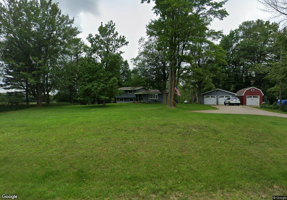
N4769 R 1 Dr Wallace, MI 49893
Estimated Value: $209,000 - $365,000
--
Bed
--
Bath
2,397
Sq Ft
$123/Sq Ft
Est. Value
About This Home
This home is located at N4769 R 1 Dr, Wallace, MI 49893 and is currently estimated at $294,534, approximately $122 per square foot. N4769 R 1 Dr is a home with nearby schools including Stephenson Area Public School, Stephenson High School, and Stephenson Middle School.
Ownership History
Date
Name
Owned For
Owner Type
Purchase Details
Closed on
Mar 24, 2010
Sold by
Federal National Mortgage
Bought by
Menza Eric and Menza Kelley
Current Estimated Value
Purchase Details
Closed on
Aug 14, 2009
Sold by
Pearson Darin
Purchase Details
Closed on
Feb 15, 2008
Sold by
Menza Eric
Bought by
Pearson Darin
Purchase Details
Closed on
Nov 5, 2004
Sold by
Marineau Gary
Bought by
Eric Menza
Purchase Details
Closed on
Feb 13, 2003
Sold by
Marineau Gary and Marineau Nancy
Bought by
Marineau Nancy
Purchase Details
Closed on
Nov 16, 1999
Sold by
Marineau Gary and Marineau Nancy
Bought by
Menza Eric
Create a Home Valuation Report for This Property
The Home Valuation Report is an in-depth analysis detailing your home's value as well as a comparison with similar homes in the area
Home Values in the Area
Average Home Value in this Area
Purchase History
| Date | Buyer | Sale Price | Title Company |
|---|---|---|---|
| Menza Eric | $33,900 | -- | |
| -- | $86,200 | -- | |
| Pearson Darin | $82,500 | -- | |
| Eric Menza | -- | -- | |
| Marineau Nancy | -- | -- | |
| Menza Eric | -- | -- |
Source: Public Records
Tax History Compared to Growth
Tax History
| Year | Tax Paid | Tax Assessment Tax Assessment Total Assessment is a certain percentage of the fair market value that is determined by local assessors to be the total taxable value of land and additions on the property. | Land | Improvement |
|---|---|---|---|---|
| 2025 | $1,619 | $116,500 | $7,800 | $108,700 |
| 2024 | $1,370 | $104,500 | $7,000 | $97,500 |
| 2023 | $333 | $78,300 | $78,300 | $0 |
| 2022 | $333 | $78,300 | $78,300 | $0 |
| 2021 | $333 | $0 | $0 | $0 |
| 2020 | $333 | $64,800 | $0 | $0 |
| 2019 | -- | $75,100 | $0 | $0 |
| 2018 | -- | $69,800 | $69,800 | $0 |
| 2017 | -- | $66,900 | $66,900 | $0 |
| 2016 | -- | $40,200 | $0 | $0 |
| 2015 | -- | $40,200 | $0 | $0 |
| 2014 | -- | $39,500 | $39,500 | $0 |
| 2013 | $333 | $36,900 | $0 | $0 |
Source: Public Records
Map
Nearby Homes
- N8968 S Park Dr
- 0 Bruette Rd Unit 50314133
- 0 Bruette Rd Unit 50314128
- 0 Bruette Rd Unit 50312014
- W5798 12 5 Rd
- W6285 Co G-08 Rd
- 0 Old Rail Rd
- W2368 Cth Jj
- W2368 County Road Jj
- W2365 Twin Pine Ln
- N6403 County Road 577
- N7775 Rastall Rd
- 0 State Hwy 180 Unit 50254740
- 0 State Hwy 180 Unit 50254737
- 0 State Hwy 180 Unit 50254736
- W3030 State Highway 180
- W5488 County Road 342
- N6491 Hwy 577
- W6496 Number 7 Ln
- 0 N 2 Ln
- N4798 R 1 Dr
- N4799 R 1 Dr
- N4725 R 1 Dr
- N4705 R 1 Dr
- N4834 R 1 Dr
- W6848 Number 11.5 Rd
- N4878 R 1 Dr
- W6794 Number 11.5 Rd
- W6797 Number 11.5 Rd
- N4746 River Dr
- N4831 River Dr
- W6704 Number 11.5 Rd
- W7016 County Road 338
- W7016 County Rd 338
- N5024 County Road 581
- N5133 County Road 581
- N5125 County Road 581
- N4654 River Dr
- W6743 Number 12 Rd
- W6710 County Road 338