Estimated payment $2,888/month
About This Lot
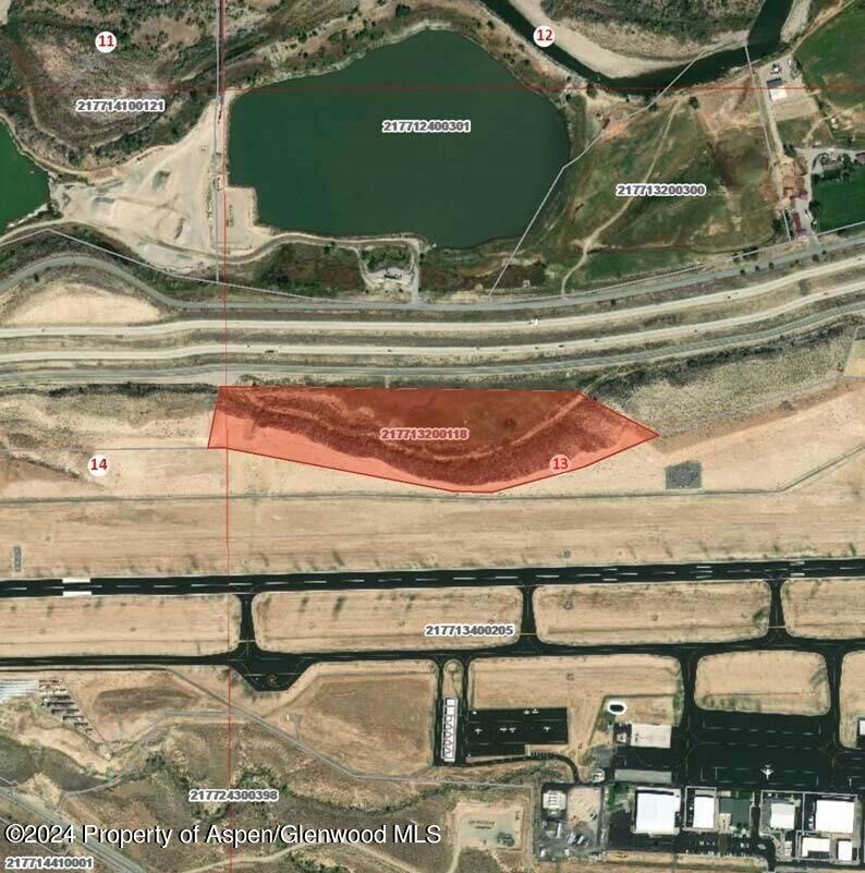
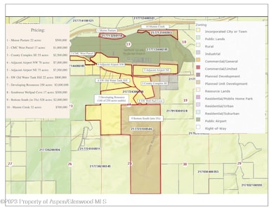
''Moose Pasture'' - 22 acres Water rights are deeded to the city of Rifle as part of development approvals. Mineral rights to be excluded from property sale.
Listing Agent
Leverich and Carr Real Estate Brokerage Phone: (970) 925-5400 License #ER212181 Listed on: 01/26/2024
Property Details
Property Type
- Land
Est. Annual Taxes
- $3,134
Lot Details
- 22 Acre Lot
- Property is zoned Agricultural
Location
- Mineral Rights Excluded
Community Details
- No Home Owners Association
Listing and Financial Details
- Assessor Parcel Number 217713200118
Map
Home Values in the Area
Average Home Value in this Area
Tax History
| Year | Tax Paid | Tax Assessment Tax Assessment Total Assessment is a certain percentage of the fair market value that is determined by local assessors to be the total taxable value of land and additions on the property. | Land | Improvement |
|---|---|---|---|---|
| 2024 | $3,623 | $51,620 | $51,620 | $0 |
| 2023 | $3,623 | $51,620 | $51,620 | $0 |
| 2022 | $58 | $880 | $880 | $0 |
| 2021 | $72 | $970 | $970 | $0 |
| 2020 | $42 | $630 | $630 | $0 |
| 2019 | $40 | $630 | $630 | $0 |
| 2018 | $28 | $430 | $430 | $0 |
| 2017 | $25 | $430 | $430 | $0 |
| 2016 | $21 | $410 | $410 | $0 |
| 2015 | $19 | $410 | $410 | $0 |
| 2014 | $11 | $240 | $240 | $0 |
Property History
| Date | Event | Price | List to Sale | Price per Sq Ft |
|---|---|---|---|---|
| 01/26/2024 01/26/24 | For Sale | $500,000 | -- | -- |
Purchase History
| Date | Type | Sale Price | Title Company |
|---|---|---|---|
| Deed Of Distribution | -- | None Listed On Document | |
| Deed | $2,000,000 | -- |
Source: Aspen Glenwood MLS
MLS Number: 182325
APN: R024418
Disclaimer: Certain information contained herein is derived from information provided by parties other than Homes.com. All information provided is deemed reliable, but is not guaranteed to be accurate and should be independently verified.
![]() IDX information is provided exclusively for personal, non-commercial use, and may not be used for any purpose other than to identify prospective properties consumers may be interested in purchasing. Information is deemed reliable but not guaranteed.
IDX information is provided exclusively for personal, non-commercial use, and may not be used for any purpose other than to identify prospective properties consumers may be interested in purchasing. Information is deemed reliable but not guaranteed.
- TBD Cty Rd 352 ''Adj Airport Nw''
- TBD Cty Rd 319 ''Cmc West Parcel''
- TBD Cty Rd 352''Adj Airport Ne''
- 545 County Road 352
- TBD Mamm Crk Rd ''Mamm Crk Exit''
- 2135 Airport Rd
- 1797 County Road 346
- TBD Cty Rd 352 ''County Cmplexse''
- TBD Cty Rd 333 ''Old Water Tank''
- Tbd Blacktail Dr
- TBD Cty Rd 333''Sw Well Pad Cove''
- 30412 U S 6
- 449 County Road 223
- 27653 Highway 6 Unit 310
- TBD Cty Rd 333''Dvlpng Resources''
- TBD Hunter Mesa ''Bottom South''
- 756 Airport Rd
- 756 Airport Rd Unit 9 AC
- 1546 E 12th St
- 1526 Dogwood Dr
- 1322 E 7th St Unit 3
- 405 E 1st St Unit 405 E 1st
- 800 S Whiteriver Ave Unit 8E
- 548 E 12th St
- 2404 West Ave
- 2433 Rail Ave
- 1410 Em Ave
- 601 Little Cloud
- 796 Castle Valley Blvd Unit E
- 792 Castle Valley Blvd Unit A
- 52089 Highway 6
- 300 Wulfsohn Rd
- 515 Flat Top View Dr
- 702 Midland Ave
- 2701 Midland Ave Unit 813
- 2701 Midland Ave Unit 511
- 736 Bennett Ave
- 649 Saddleback Rd
