


TBD Harmony Ln Carbondale, CO 81623
Estimated payment $12,931/month
Total Views
2,573
37
Acres
$57,112
Price per Acre
1,601,701
Sq Ft Lot
Highlights
- 36.77 Acre Lot
- Views
- Lot Has A Rolling Slope
- No HOA
About This Lot
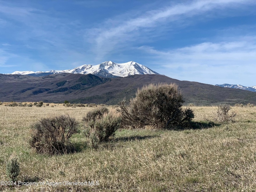
This 36.45-acre parcel in Missouri Heights offers a rare combination of size, privacy, and proximity to the valley floor. Large properties in this location are increasingly difficult to find. Recent sales of nearby 5-acre lots at $875,000 underscore the value represented here.A well has been drilled and the pump is installed. Electricity is available at the lot line. The terrain is gently rolling and well-suited for equestrian use or other recreational purposes.The property is located approximately 32 minutes from Aspen, providing convenient access to dining, shopping, and outdoor activities while maintaining a quiet, rural setting.This is a practical opportunity to acquire a sizable tract of land in one of the region's most sought-after areas.
Listing Agent
Tobias Munk Broker Brokerage Phone: (970) 279-4266 License #II.40045265 Listed on: 03/16/2025
Property Details
Property Type
- Land
Est. Annual Taxes
- $17,197
Lot Details
- 36.77 Acre Lot
- Lot Has A Rolling Slope
- Property is zoned Zoning
Additional Homes
- Accessory Dwelling Unit (ADU)
Utilities
- Gas Available
- Water Rights
- Well
- Septic Tank
- Septic System
Additional Features
- Property Views
Community Details
- No Home Owners Association
Listing and Financial Details
- Property Available on 3/7/25
- Assessor Parcel Number 239128300224
Map
Create a Home Valuation Report for This Property
The Home Valuation Report is an in-depth analysis detailing your home's value as well as a comparison with similar homes in the area
Home Values in the Area
Average Home Value in this Area
Tax History
| Year | Tax Paid | Tax Assessment Tax Assessment Total Assessment is a certain percentage of the fair market value that is determined by local assessors to be the total taxable value of land and additions on the property. | Land | Improvement |
|---|---|---|---|---|
| 2024 | $17,647 | $237,150 | $237,150 | $0 |
| 2023 | $17,647 | $237,150 | $237,150 | $0 |
| 2022 | $8,812 | $108,750 | $108,750 | $0 |
| 2021 | $8,676 | $108,750 | $108,750 | $0 |
| 2020 | $10,186 | $134,850 | $134,850 | $0 |
| 2019 | $10,277 | $134,850 | $134,850 | $0 |
| 2018 | $9,869 | $130,500 | $130,500 | $0 |
| 2017 | $9,434 | $130,500 | $130,500 | $0 |
| 2016 | $9,614 | $130,500 | $130,500 | $0 |
| 2015 | $9,755 | $130,500 | $130,500 | $0 |
| 2014 | $9,044 | $130,500 | $130,500 | $0 |
Source: Public Records
Property History
| Date | Event | Price | Change | Sq Ft Price |
|---|---|---|---|---|
| 05/24/2025 05/24/25 | Price Changed | $2,100,000 | +5.3% | -- |
| 12/15/2024 12/15/24 | For Sale | $1,995,000 | +432.0% | -- |
| 06/04/2020 06/04/20 | Sold | $375,000 | -16.7% | -- |
| 04/07/2020 04/07/20 | Pending | -- | -- | -- |
| 05/23/2019 05/23/19 | For Sale | $450,000 | -- | -- |
Source: Aspen Glenwood MLS
Purchase History
| Date | Type | Sale Price | Title Company |
|---|---|---|---|
| Survivorship Deed | $375,000 | Land Title Guarantee Co |
Source: Public Records
Similar Property in Carbondale, CO
Source: Aspen Glenwood MLS
MLS Number: 186311
APN: R112039
Disclaimer: Certain information contained herein is derived from information provided by parties other than Homes.com. All information provided is deemed reliable, but is not guaranteed to be accurate and should be independently verified.
![]() IDX information is provided exclusively for personal, non-commercial use, and may not be used for any purpose other than to identify prospective properties consumers may be interested in purchasing. Information is deemed reliable but not guaranteed.
IDX information is provided exclusively for personal, non-commercial use, and may not be used for any purpose other than to identify prospective properties consumers may be interested in purchasing. Information is deemed reliable but not guaranteed.
Nearby Homes
- 577 Fox Run Dr
- 14 Fender Ln
- 500 Whitecloud Rd
- 564 Larkspur Dr
- 623 Fender Ln
- 604 Larkspur Dr
- TBD Spring Park Ridge
- 379 Caballo St
- 165 Dakota Meadows Dr
- 456 Black Bear Trail
- 861 Green Meadow Dr
- 0811 Green Meadow Dr
- 313 Cerise Ranch Rd
- 222 Fawn Dr
- 450 Green Meadow Dr
- 309 Deer Run
- 203 Deer Run
- 960 County Road 102
- 488 Skipper Dr
- 67 Rabbit Rd
- 579 Larkspur Dr
- 17 Dakota Ct
- 661 Green Meadow Dr
- 1840 Upper Cattle Creek Rd
- 111 Juniper Trail
- 142 Juniper Trail
- 162 Juniper Trail
- 160 Equestrian Way
- 231 Robinson St Unit R330
- 231 Robinson St Unit R212
- 712 Buckpoint Rd
- 231 Robinson St Unit 332
- 1434 Hooks Spur Rd
- 401 Robinson St
- 5 Tree Farm Dr
- 14913 Highway 82 Unit 109
- 14913 Highway 82 Unit 137
- 333 Sopris Cir
- 211 Juniper Ct
- 210 Juniper Ct