


Highlights
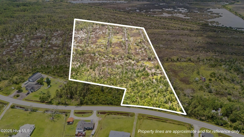
- 19.96 Acre Lot
- Wooded Lot
- No HOA
About This Lot
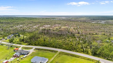
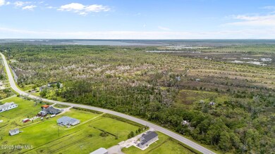
Sprawling 19.96-acre parcel on US-70 E in Davis, NC, offering endless possibilities in the heart of Carteret County's Down East Community! Currently use as hunting land, this expansive lot boasts direct highway access and is zoned for residential use! Best Widgeon Hunting, Bear and Deer tracks also noted. Just 12 miles from historic Beaufort and close to Morehead City's amenities, enjoy proximity to pristine beaches, fishing, and boating. Ideal for hunting, fishing, or exploring development potential. Don't miss this rare opportunity to own almost 20 acres in a serene coastal community!
Property Details
Property Type
- Land
Lot Details
- 19.96 Acre Lot
- Lot Dimensions are 296x130x245x1502x866x1350
- Property fronts a state road
- Wooded Lot
Schools
- Smyrna Elementary School
- East Carteret High School
Community Details
- No Home Owners Association
- Davis Bay Subdivision
Listing and Financial Details
- Assessor Parcel Number 736901364819000
Map
Home Values in the Area
Average Home Value in this Area
Property History
| Date | Event | Price | List to Sale | Price per Sq Ft |
|---|---|---|---|---|
| 02/09/2026 02/09/26 | Price Changed | $130,000 | -13.3% | -- |
| 12/01/2025 12/01/25 | Price Changed | $150,000 | -11.7% | -- |
| 07/14/2025 07/14/25 | For Sale | $169,900 | -- | -- |
Source: Hive MLS
MLS Number: 100518978
Disclaimer: Certain information contained herein is derived from information provided by parties other than Homes.com. All information provided is deemed reliable, but is not guaranteed to be accurate and should be independently verified.
![]() The data relating to real estate on this web site comes in part from the Internet Data Exchange program of Hive MLS LLC. All information is deemed reliable but not guaranteed and should be independently verified. All properties are subject to prior sale, change, or withdrawal. Neither listing broker(s) nor Homesnap, Inc. shall be responsible for any typographical errors, misinformation, or misprints, and shall be held totally harmless from any damages arising from reliance upon these data. ©2026 Hive MLS LLC
The data relating to real estate on this web site comes in part from the Internet Data Exchange program of Hive MLS LLC. All information is deemed reliable but not guaranteed and should be independently verified. All properties are subject to prior sale, change, or withdrawal. Neither listing broker(s) nor Homesnap, Inc. shall be responsible for any typographical errors, misinformation, or misprints, and shall be held totally harmless from any damages arising from reliance upon these data. ©2026 Hive MLS LLC
- 811 U S 70
- 111 Croaker St
- 289 Croaker St
- 1150 U S 70
- 470 Highway 70 Williston
- 145 Williston Creek Rd
- 280 Donnie Davis Rd
- 138 Old Nassau Rd
- 112 Stephen Willis Rd
- 202 Stephen Willis Rd
- 210 Hill Rd
- 930 U S 70
- 170 Pasture Point Ln
- 0 Highway 70 Unit 100377588
- 203 Old Carteret Rd
- 191 Old Carteret Rd
- 181 Old Carteret Rd
- 527 Marshallberg Rd
- 736 Marshallberg
- 0 Bells Island Unit 100531056
- 141 Black Duck Rd
- 1158 Hwy 70 Otway
- 383 Highway 70 Otway
- 317 Taylorwood Dr
- 319 Taylorwood Dr
- 232 Rutledge Ave
- 1103 Pirates Landing Dr
- 122 Short St
- 2005 Lennoxville Rd Unit B
- 100 Madison Bay Dr
- 736 Comet Dr
- 113 Circle Dr
- 107 Sunshine Ct
- 1527 Front St Unit B
- 312 Marsh St Unit F
- 111 Live Oak St
- 122 Craven St Unit A
- 221 Front St
- 126 Sunset Ln
- 133 Cummins Creek Rd

Ask me questions while you tour the home.