
Seller's Agent in 2020
Renda Fisher
First Choice Realty
(573) 216-8987
30 in this area
62 Total Sales

Estimated Value: $276,300 - $314,000
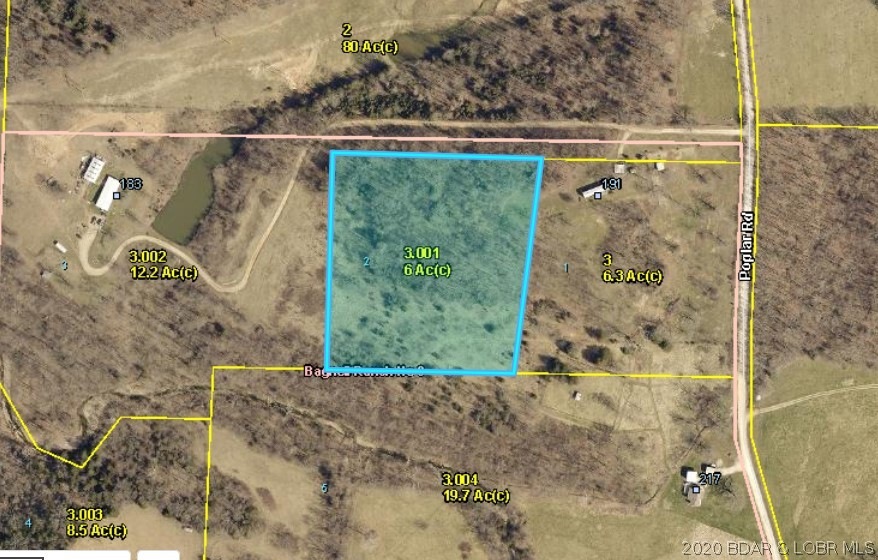
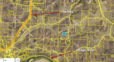
Six acre building lot just minutes from the Osage River and Lake of the Ozarks.
Last Agent to Sell the Property
First Choice Realty License #1999084984 Listed on: 03/24/2020
Last Buyer's Agent
WEEG & ASSOCIATE THE OZARKS REAL ESTATE
Keller Williams L.O. Realty License #2001011996
| Date | Buyer | Sale Price | Title Company |
|---|---|---|---|
| Summers Jon P | -- | Legend Land Services | |
| Summers Jon P | -- | Legend Land Services | |
| Blue Ridge Properties Llc | $1,500 | None Available | |
| Blue Ridge Properties Llc | $1,500 | None Available |
| Date | Status | Borrower | Loan Amount |
|---|---|---|---|
| Open | Summers Jon P | $298,000 | |
| Closed | Summers Jon P | $298,000 |
| Date | Event | Price | List to Sale | Price per Sq Ft |
|---|---|---|---|---|
| 08/21/2020 08/21/20 | Sold | -- | -- | -- |
| 07/22/2020 07/22/20 | Pending | -- | -- | -- |
| 03/24/2020 03/24/20 | For Sale | $20,000 | -- | -- |
| Year | Tax Paid | Tax Assessment Tax Assessment Total Assessment is a certain percentage of the fair market value that is determined by local assessors to be the total taxable value of land and additions on the property. | Land | Improvement |
|---|---|---|---|---|
| 2025 | $783 | $16,770 | $2,040 | $14,730 |
| 2024 | $692 | $14,670 | $1,850 | $12,820 |
| 2023 | $516 | $14,670 | $1,850 | $12,820 |
| 2022 | $516 | $11,310 | $1,850 | $9,460 |
| 2021 | $84 | $1,850 | $1,850 | $0 |
| 2020 | $59 | $1,280 | $1,280 | $0 |
| 2019 | $59 | $1,280 | $1,280 | $0 |
| 2018 | $57 | $1,280 | $1,280 | $0 |
| 2017 | $55 | $1,230 | $1,230 | $0 |
| 2016 | $54 | $1,230 | $0 | $0 |
| 2015 | -- | $1,230 | $0 | $0 |
| 2012 | -- | $1,240 | $0 | $0 |
Seller's Agent in 2020
Renda Fisher
First Choice Realty
(573) 216-8987
30 in this area
62 Total Sales
W
Buyer's Agent in 2020
WEEG & ASSOCIATE THE OZARKS REAL ESTATE
Keller Williams L.O. Realty
(573) 216-3819
6 in this area
150 Total Sales
Buyer Co-Listing Agent in 2020
SUMMER PHILLIPS
Keller Williams L.O. Realty
(573) 480-5711
1 in this area
21 Total Sales
Source: Bagnell Dam Association of REALTORS®
MLS Number: 3523480
APN: 121002000000003001
Disclaimer: Certain information contained herein is derived from information provided by parties other than Homes.com. All information provided is deemed reliable, but is not guaranteed to be accurate and should be independently verified.
![]() IDX information is provided exclusively for personal, non-commercial use, and may not be used for any purpose other than to identify prospective properties consumers may be interested in purchasing. Information is deemed reliable but not guaranteed.
IDX information is provided exclusively for personal, non-commercial use, and may not be used for any purpose other than to identify prospective properties consumers may be interested in purchasing. Information is deemed reliable but not guaranteed.
Ask me questions while you tour the home.