Estimated Value: $315,000 - $486,604
10
Acres
$38,615
Price per Acre
435,600
Sq Ft Lot
Highlights
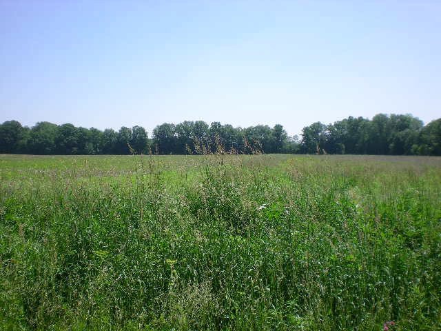
- Partially Wooded Lot
- Home fronts a stream
- Level Lot
- Pasture
- Partially Fenced Property
About This Lot
As of October 2012The is a level tract that has a small stream on the southside of the lot. It has woods in the back souteast corner. The lot has had the soil reviewed for onsite septic. Great Homesite or farm
Property Details
Property Type
- Land
Est. Annual Taxes
- $298
Lot Details
- 10 Acre Lot
- Home fronts a stream
- Partially Fenced Property
- Level Lot
- Open Lot
- Partially Wooded Lot
Farming
- Tillable Land
- Pasture
Utilities
- Phone Available
Listing and Financial Details
- Tax Lot 12u-3
- Assessor Parcel Number g220120000202
Ownership History
Date
Name
Owned For
Owner Type
Purchase Details
Listed on
Aug 30, 2012
Closed on
Oct 16, 2012
Sold by
Keds Real Estate Llc
Bought by
Andress Timothy A and Andress Amy J
List Price
$44,900
Sold Price
$42,500
Premium/Discount to List
-$2,400
-5.35%
Current Estimated Value
Home Financials for this Owner
Home Financials are based on the most recent Mortgage that was taken out on this home.
Estimated Appreciation
$343,651
Avg. Annual Appreciation
18.36%
Purchase Details
Closed on
Nov 24, 2009
Bought by
Robinett Glen N and Robinett Traci A
Purchase Details
Closed on
Jul 17, 1995
Create a Home Valuation Report for This Property
The Home Valuation Report is an in-depth analysis detailing your home's value as well as a comparison with similar homes in the area
Home Values in the Area
Average Home Value in this Area
Purchase History
| Date | Buyer | Sale Price | Title Company |
|---|---|---|---|
| Andress Timothy A | $42,500 | -- | |
| Robinett Glen N | $36,500 | -- | |
| -- | $27,000 | -- |
Source: Public Records
Mortgage History
| Date | Status | Borrower | Loan Amount |
|---|---|---|---|
| Closed | Andress Timothy A | $34,000 |
Source: Public Records
Property History
| Date | Event | Price | List to Sale | Price per Sq Ft |
|---|---|---|---|---|
| 10/16/2012 10/16/12 | Sold | $42,500 | -5.3% | -- |
| 09/16/2012 09/16/12 | Pending | -- | -- | -- |
| 08/30/2012 08/30/12 | For Sale | $44,900 | -- | -- |
Source: Ashland Board of REALTORS®
Tax History Compared to Growth
Tax History
| Year | Tax Paid | Tax Assessment Tax Assessment Total Assessment is a certain percentage of the fair market value that is determined by local assessors to be the total taxable value of land and additions on the property. | Land | Improvement |
|---|---|---|---|---|
| 2024 | $4,392 | $118,010 | $31,170 | $86,840 |
| 2023 | $4,392 | $118,010 | $31,170 | $86,840 |
| 2022 | $4,303 | $90,780 | $23,980 | $66,800 |
| 2021 | $4,319 | $90,780 | $23,980 | $66,800 |
| 2020 | $4,186 | $90,780 | $23,980 | $66,800 |
| 2019 | $4,119 | $82,690 | $19,630 | $63,060 |
| 2018 | $4,133 | $82,690 | $19,630 | $63,060 |
| 2017 | $4,107 | $82,690 | $19,630 | $63,060 |
| 2016 | $3,797 | $73,170 | $17,370 | $55,800 |
| 2015 | $3,767 | $73,170 | $17,370 | $55,800 |
| 2013 | $621 | $11,640 | $11,640 | $0 |
Source: Public Records
Source: Ashland Board of REALTORS®
MLS Number: 214978
APN: G22-012-0-0002-02
Nearby Homes
- 1653 Ohio 60
- 1653 State Route 60
- 0 Twp Rd 1806 Unit 11591470
- 1845 County Road 655
- 1690 County Road 995
- 1015 Township Road 1696
- 1581 County Road 995
- 1457 Township Road 853
- 820 County Road 30a
- 150 E Main St
- 1446 Township Road 805
- 1435 Township Road 853
- 977 Township Road 1514 Unit C
- 0 Eagle Way
- 1331 Eastern Ave
- 453 Hillcrest Dr
- 1109 Eastern Ave
- 1011 Eastern Ave
- 31 Morgan Ave
- 1706 Kingwood Ct
- 929 Twp 1243 Rd
- 1129 tr N Twp1293
- 1438 Township 1238 Rd
- 1427 T R 1714
- 1442 T R 1714
- 1341 T R 1714
- 1243 T R 1714
- 1475 T R 1714
- 1281 T R 1714
- 1035 T R 1714
- 1247 T R 1714
- 1138 Twp 1704
- 1177 T R 1714
- 876 T R 1714
- 222 T R 1714
- 150 T R 1714
- 1725 Township Road 1714
- 1727 1714
- 1727 Township Road 1714
- 1717 State Route 60