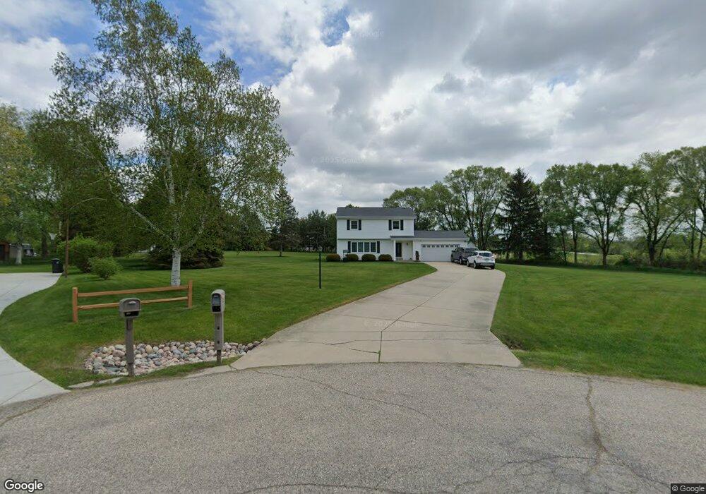
W227S8470 King St Big Bend, WI 53103
Estimated Value: $413,504 - $584,000
--
Bed
--
Bath
--
Sq Ft
1.88
Acres
About This Home
This home is located at W227S8470 King St, Big Bend, WI 53103 and is currently estimated at $488,876. W227S8470 King St is a home located in Waukesha County with nearby schools including Big Bend Elementary School, Park View Middle School, and Mukwonago High School.
Ownership History
Date
Name
Owned For
Owner Type
Purchase Details
Closed on
Jan 22, 2013
Sold by
Cavanaugh Gregory M
Bought by
Aspuro Gilbert and Aspuro Mary
Current Estimated Value
Purchase Details
Closed on
Mar 3, 2000
Sold by
Alvey Timothy G and Kies Carlotte A
Bought by
Aspuro Gilbert and Aspuro Mary E
Home Financials for this Owner
Home Financials are based on the most recent Mortgage that was taken out on this home.
Original Mortgage
$129,600
Interest Rate
7.9%
Create a Home Valuation Report for This Property
The Home Valuation Report is an in-depth analysis detailing your home's value as well as a comparison with similar homes in the area
Home Values in the Area
Average Home Value in this Area
Purchase History
| Date | Buyer | Sale Price | Title Company |
|---|---|---|---|
| Aspuro Gilbert | $300 | None Available | |
| Aspuro Gilbert | $162,000 | -- |
Source: Public Records
Mortgage History
| Date | Status | Borrower | Loan Amount |
|---|---|---|---|
| Previous Owner | Aspuro Gilbert | $129,600 |
Source: Public Records
Tax History Compared to Growth
Tax History
| Year | Tax Paid | Tax Assessment Tax Assessment Total Assessment is a certain percentage of the fair market value that is determined by local assessors to be the total taxable value of land and additions on the property. | Land | Improvement |
|---|---|---|---|---|
| 2024 | $3,027 | $373,800 | $111,500 | $262,300 |
| 2023 | $2,931 | $373,800 | $111,500 | $262,300 |
| 2022 | $3,302 | $300,200 | $87,000 | $213,200 |
| 2021 | $3,257 | $300,200 | $87,000 | $213,200 |
| 2020 | $3,315 | $300,200 | $87,000 | $213,200 |
| 2019 | $3,087 | $250,800 | $74,800 | $176,000 |
| 2018 | $3,109 | $250,800 | $74,800 | $176,000 |
| 2017 | $2,810 | $228,400 | $74,800 | $153,600 |
| 2016 | $2,800 | $228,400 | $74,800 | $153,600 |
| 2015 | $2,753 | $228,400 | $74,800 | $153,600 |
| 2014 | $2,928 | $229,600 | $75,000 | $154,600 |
| 2013 | $2,928 | $229,600 | $75,000 | $154,600 |
Source: Public Records
Map
Nearby Homes
- S83W23145 Artesian Ave
- W232S8430 Rosemary Dr
- Lt2 Marianne Ave
- Pcl0 Clark St
- Lt11 Leo Ln
- Lt12 Leo Ln
- Lt7 Leo Ln
- Lt8 Leo Ln
- Lt9 Leo Ln
- Lt10 Leo Ln
- Lt13 Leo Ln
- S80W23790 Parkview Dr
- Lt14 Leo Ln
- Lt15 Leo Ln
- Lt16 Leo Ln
- S95W23000 River Oaks Dr
- S94W23620 Kunzendorf Ct
- S95W22835 Bywater Ln
- S96W22870 River Oaks Dr
- Lt2 Russet Ct
- W227S8450 King St
- W228S8485 King St
- W228S8465 King St
- W227S8430 King St
- W228S8445 King St
- S85W22755 Lake Park Dr
- S85W22755 Lake Park Dr Unit S85W22755
- S84W22775 Martin St
- S84W22755 Martin St
- S84W22835 Martin St
- W228S8470 Mardith Ave
- W228S8460 Mardith Ave
- W228S8510 Mardith Ave
- W228S8440 Mardith Ave
- S83W22790 Martin St
- W228S8430 Mardith Ave
- W228S8520 Mardith Ave
- S83W22770 Martin St
- S84W22885 Martin St
- S83W22850 Martin St