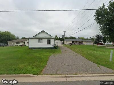
W636 Co Rd N Aurora T-Wi, WI 54151
Estimated Value: $165,000 - $179,600
1
Bed
2
Baths
1,090
Sq Ft
$160/Sq Ft
Est. Value
About This Home
This home is located at W636 Co Rd N, Aurora T-Wi, WI 54151 and is currently estimated at $173,900, approximately $159 per square foot. W636 Co Rd N is a home located in Florence County with nearby schools including Florence Elementary School, Florence Middle School, and Florence High School.
Ownership History
Date
Name
Owned For
Owner Type
Purchase Details
Closed on
Feb 17, 2023
Sold by
Hendrickson Michael R
Bought by
Latitude North 45 Llc
Current Estimated Value
Home Financials for this Owner
Home Financials are based on the most recent Mortgage that was taken out on this home.
Original Mortgage
$145,117
Outstanding Balance
$141,602
Interest Rate
6.48%
Mortgage Type
Construction
Estimated Equity
$30,307
Purchase Details
Closed on
May 24, 2016
Sold by
Moore Alfred M
Bought by
Hendrickson Michael R
Create a Home Valuation Report for This Property
The Home Valuation Report is an in-depth analysis detailing your home's value as well as a comparison with similar homes in the area
Home Values in the Area
Average Home Value in this Area
Purchase History
| Date | Buyer | Sale Price | Title Company |
|---|---|---|---|
| Latitude North 45 Llc | $160,600 | -- | |
| Hendrickson Michael R | $93,000 | -- |
Source: Public Records
Mortgage History
| Date | Status | Borrower | Loan Amount |
|---|---|---|---|
| Open | Latitude North 45 Llc | $145,117 | |
| Previous Owner | Hendrickson Michael R | $20,000 | |
| Closed | Latitude North 45 Llc | $50,000 |
Source: Public Records
Tax History Compared to Growth
Tax History
| Year | Tax Paid | Tax Assessment Tax Assessment Total Assessment is a certain percentage of the fair market value that is determined by local assessors to be the total taxable value of land and additions on the property. | Land | Improvement |
|---|---|---|---|---|
| 2024 | $2,382 | $149,600 | $23,400 | $126,200 |
| 2023 | $2,075 | $83,200 | $20,500 | $62,700 |
| 2022 | $1,914 | $83,200 | $20,500 | $62,700 |
| 2021 | $1,711 | $83,200 | $20,500 | $62,700 |
| 2020 | $1,793 | $83,200 | $20,500 | $62,700 |
| 2019 | $1,712 | $83,200 | $20,500 | $62,700 |
| 2018 | $1,727 | $83,200 | $20,500 | $62,700 |
| 2017 | $1,691 | $83,200 | $20,500 | $62,700 |
| 2016 | $1,685 | $83,200 | $20,500 | $62,700 |
| 2013 | $1,679 | $83,200 | $20,500 | $62,700 |
Source: Public Records
Map
Nearby Homes
- 521 Lawrence St
- 412 Case St
- 1317 W Breen Ave
- 1200 & 1204 W Breen
- 209 Newton St
- 224 Hooper St
- 144 Case St
- 513 W Sagola Ave
- 729 W Breitung Ave
- 860 Evergreen Ct
- 424 Withworth Ave
- 624 E Breitung Ave
- 1045 Superior Ave
- 1015 Michigan Ave
- 412 Hamilton Ave
- 113 Wilson Ave
- 536 Woodward Ave
- 1100 Michigan Ave
- 421 Wright St
- 1252 S Kimberly Ave
- W636 Co Rd N
- W636 County Rd N
- W642 County Rd N
- W632 County Rd N
- W644 County Rd N
- W637 County Rd N
- W628 County Rd N
- 1911 Maple St
- W624 County Rd N
- W647 County Rd N
- 1901 Birch St
- W620 County Rd N
- W651 County Rd N
- W621 County Rd N
- W656 County Rd N
- W655 County Rd N
- W612 Co Rd N
- W612 County Rd N
- W613 County Rd N
- 537 Ridge St