0 Airways Blvd Unit 10199303 Memphis, TN 38114
Southeast Memphis NeighborhoodEstimated payment $282/month
About This Lot
Commercial Lot/Land available on Airways, Great business opportunity.
Property Details
Property Type
- Land
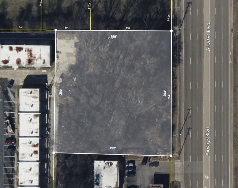
Lot Details
- 0.89 Acre Lot
- Lot Dimensions are 204 x 194.3
- Level Lot
- Property is zoned RU-3
Location
- City Lot
Community Details
- Airways Rd Subdivision
Listing and Financial Details
- Assessor Parcel Number 079086 00024
Map
Home Values in the Area
Average Home Value in this Area
Property History
| Date | Event | Price | List to Sale | Price per Sq Ft |
|---|---|---|---|---|
| 06/18/2025 06/18/25 | For Sale | $45,000 | -- | -- |
Source: Memphis Area Association of REALTORS®
MLS Number: 10199303
Disclaimer: Certain information contained herein is derived from information provided by parties other than Homes.com. All information provided is deemed reliable, but is not guaranteed to be accurate and should be independently verified.
![]() Listing content and images Copyright 2025 Memphis Area Association of REALTORS®. Information provided is for the consumer’s personal, non-commercial use and may not be used for any purpose other than to identify prospective properties consumers may be interested in purchasing. Do not rely upon listing data without independently verifying it.
Listing content and images Copyright 2025 Memphis Area Association of REALTORS®. Information provided is for the consumer’s personal, non-commercial use and may not be used for any purpose other than to identify prospective properties consumers may be interested in purchasing. Do not rely upon listing data without independently verifying it.
Some or all of the listings displayed may not belong to the firm whose website is being visited.
- 1720 Airways Blvd
- 2336 Boyle Ave
- 2481 Kimball Ave
- 1059 S Willett St S
- 2383 Lowell Ave
- 2481 Browning Ave
- 2421 Arlington Ave
- 2589 Browning Ave
- 2151 Goff Ave
- 2149 Wabash Ave
- 2512 Kenner Ave
- 2235 Charjean Rd
- 2621 Dunn Ave
- 2540 Malone Ave
- 1971 Boyle Ave
- 1817 S Barksdale St
- 2369 Lamar Ave
- 1610 Lamar Ave
- 0 Dublin Ave Unit LOTS 20 & 21 LAST TW
- 2255 Deadrick Ave
- 2370 Larose Ave
- 2295 Candlewyck Cir Unit 2254-5
- 2325 Riley Ave
- 1865 Ferber Ave
- 2723 Filmore Ave
- 2709 Henley Dr
- 1390 Grand St
- 2712 Fizer Rd
- 2459 Ketchum Rd
- 2716 Deadrick Ave
- 2541 Corporate Ave E
- 1162 Bradley St
- 2743 Ketchum Rd
- 2269 Longstreet Dr
- 1802 Edmondson Ave
- 1560 Cane Rd
- 828 Baltimore St
- 1151 Tanglewood St
- 2965 N Radford Rd
- 1804 Foster Ave
