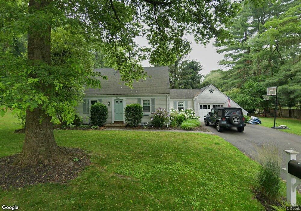
1 Briar Brae Rd Darien, CT 06820
Estimated Value: $1,338,000 - $1,440,000
3
Beds
2
Baths
1,709
Sq Ft
$800/Sq Ft
Est. Value
About This Home
This home is located at 1 Briar Brae Rd, Darien, CT 06820 and is currently estimated at $1,367,014, approximately $799 per square foot. 1 Briar Brae Rd is a home located in Fairfield County with nearby schools including Holmes Elementary School, Middlesex Middle School, and Darien High School.
Ownership History
Date
Name
Owned For
Owner Type
Purchase Details
Closed on
Dec 27, 2005
Sold by
Mccarthy Donald P and Mccarthy Eileen M
Bought by
Brennan Barry E and Brennan Claire O
Current Estimated Value
Purchase Details
Closed on
Jan 31, 2003
Sold by
Doherty Christopher and Doherty Kelsey
Bought by
Mccarthy Donald P and Mccarthy Eileen M
Purchase Details
Closed on
Mar 31, 1999
Sold by
Plunkett Robert and Plunkett Karen N
Bought by
Doherty Christopher and Doherty Kelsey
Purchase Details
Closed on
Aug 30, 1991
Sold by
Nelson Andrew and Nelson Mary
Bought by
Plunkett Robert and Plunkett Karen
Purchase Details
Closed on
Jun 12, 1987
Sold by
Mcgovern Peter
Bought by
Nelson Andrew
Create a Home Valuation Report for This Property
The Home Valuation Report is an in-depth analysis detailing your home's value as well as a comparison with similar homes in the area
Home Values in the Area
Average Home Value in this Area
Purchase History
| Date | Buyer | Sale Price | Title Company |
|---|---|---|---|
| Brennan Barry E | $799,000 | -- | |
| Mccarthy Donald P | $635,000 | -- | |
| Doherty Christopher | $485,000 | -- | |
| Plunkett Robert | $330,000 | -- | |
| Nelson Andrew | $394,000 | -- |
Source: Public Records
Mortgage History
| Date | Status | Borrower | Loan Amount |
|---|---|---|---|
| Open | Nelson Andrew | $540,000 | |
| Closed | Nelson Andrew | $465,000 |
Source: Public Records
Tax History
| Year | Tax Paid | Tax Assessment Tax Assessment Total Assessment is a certain percentage of the fair market value that is determined by local assessors to be the total taxable value of land and additions on the property. | Land | Improvement |
|---|---|---|---|---|
| 2025 | $9,820 | $634,340 | $478,170 | $156,170 |
| 2024 | $9,318 | $634,340 | $478,170 | $156,170 |
| 2023 | $8,030 | $455,980 | $341,530 | $114,450 |
| 2022 | $7,857 | $455,980 | $341,530 | $114,450 |
| 2021 | $7,679 | $455,980 | $341,530 | $114,450 |
| 2020 | $7,460 | $455,980 | $341,530 | $114,450 |
| 2019 | $0 | $455,980 | $341,530 | $114,450 |
| 2018 | $16,567 | $470,330 | $330,680 | $139,650 |
| 2017 | $7,601 | $470,330 | $330,680 | $139,650 |
| 2016 | $7,417 | $470,330 | $330,680 | $139,650 |
| 2015 | $7,220 | $470,330 | $330,680 | $139,650 |
| 2014 | $7,060 | $470,330 | $330,680 | $139,650 |
Source: Public Records
Map
Nearby Homes
- 53 Hoyt St
- 8 Barnstable Ln
- 7 Barnstable Ln
- 760 Hope St
- 910 Hope St Unit 5B
- 15 Waterbury Ln
- 680 Hope St Unit 12
- 17 Sunnyside Ave
- 43 Phillips Ln
- 473 Hollow Tree Ridge Rd
- 3 Hickory Ln
- 51 Saint Charles Ave
- 28 Crestview Ave
- 86 Middlesex Rd
- 25 Devon Rd
- 3 Abbey Rd
- 27 Northill St Unit 5S
- 27 Northill St Unit 5N
- 85 Camp Ave Unit 3B
- 85 Camp Ave Unit 18B
Your Personal Tour Guide
Ask me questions while you tour the home.