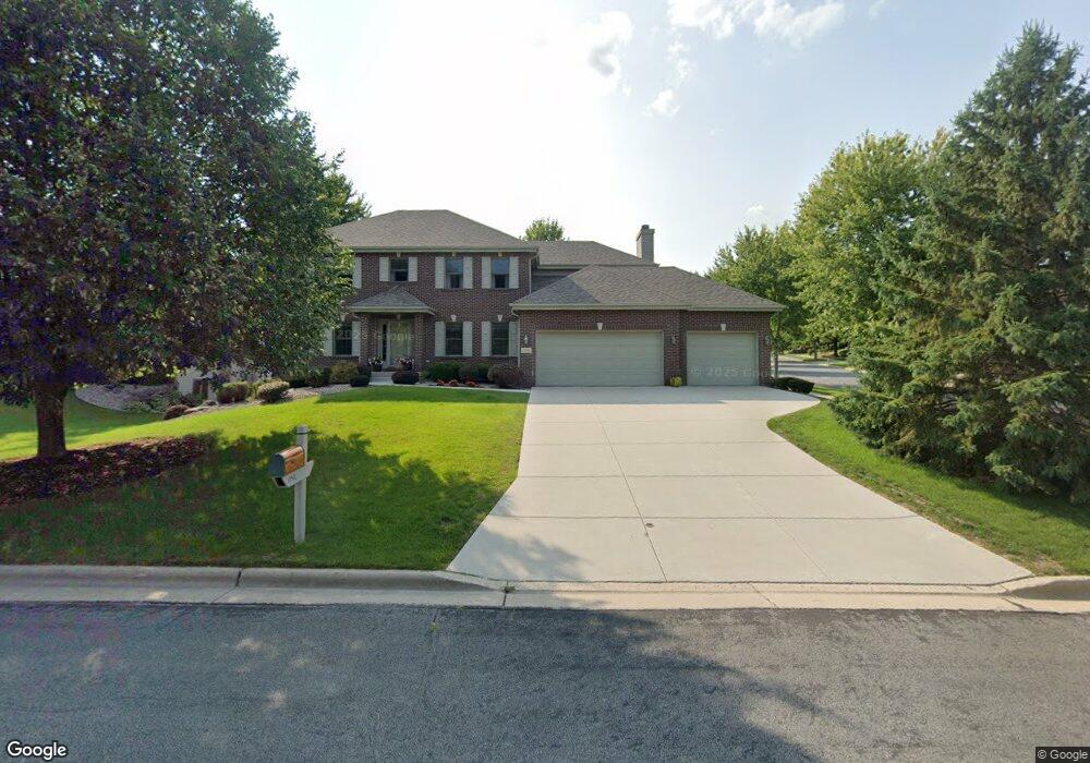
1 Monarch Cir Madison, WI 53717
Estimated Value: $885,693 - $1,164,000
5
Beds
5
Baths
2,888
Sq Ft
$347/Sq Ft
Est. Value
About This Home
This home is located at 1 Monarch Cir, Madison, WI 53717 and is currently estimated at $1,002,423, approximately $347 per square foot. 1 Monarch Cir is a home located in Dane County with nearby schools including Pope Farm Elementary School, Kromrey Middle School, and Middleton High School.
Ownership History
Date
Name
Owned For
Owner Type
Purchase Details
Closed on
Jun 29, 2011
Sold by
Boss William H and Boss Deanne L
Bought by
Boss Deanne L
Current Estimated Value
Home Financials for this Owner
Home Financials are based on the most recent Mortgage that was taken out on this home.
Original Mortgage
$170,000
Interest Rate
4.63%
Mortgage Type
New Conventional
Create a Home Valuation Report for This Property
The Home Valuation Report is an in-depth analysis detailing your home's value as well as a comparison with similar homes in the area
Home Values in the Area
Average Home Value in this Area
Purchase History
| Date | Buyer | Sale Price | Title Company |
|---|---|---|---|
| Boss Deanne L | -- | None Available |
Source: Public Records
Mortgage History
| Date | Status | Borrower | Loan Amount |
|---|---|---|---|
| Closed | Boss Deanne L | $170,000 |
Source: Public Records
Tax History
| Year | Tax Paid | Tax Assessment Tax Assessment Total Assessment is a certain percentage of the fair market value that is determined by local assessors to be the total taxable value of land and additions on the property. | Land | Improvement |
|---|---|---|---|---|
| 2025 | $12,893 | $770,900 | $238,100 | $532,800 |
| 2024 | $24,047 | $730,700 | $238,100 | $492,600 |
| 2023 | $11,176 | $682,900 | $222,500 | $460,400 |
| 2022 | $21,680 | $593,800 | $193,500 | $400,300 |
| 2021 | $10,387 | $539,800 | $175,900 | $363,900 |
| 2020 | $10,589 | $504,500 | $164,400 | $340,100 |
| 2019 | $10,357 | $494,600 | $161,200 | $333,400 |
| 2018 | $9,723 | $475,600 | $155,000 | $320,600 |
| 2017 | $10,227 | $475,600 | $155,000 | $320,600 |
| 2016 | $9,947 | $448,700 | $146,200 | $302,500 |
| 2015 | $10,438 | $427,300 | $139,200 | $288,100 |
| 2014 | $9,970 | $427,300 | $139,200 | $288,100 |
| 2013 | $9,084 | $414,900 | $135,100 | $279,800 |
Source: Public Records
Map
Nearby Homes
- 2 Coyote Ct
- 9106 Waterside St
- 1 Settler Hill Cir
- 9395 Old Sauk Rd
- 749 Cricket Ln Unit 749
- 707 Cricket Ln Unit 5
- 719 Cricket Ln Unit 3
- 551 Fargo Trail
- 9706 Sandhill Rd
- 9718 Sandhill Rd
- 9809 Trappers Trail
- 9801 Shadow Ridge Trail
- 814 Big Stone Trail
- 1014 Meadow Mist Rd
- 4206 Rose Ct
- 9414 Whippoorwill Way
- 442 Augusta Dr
- 819 Schewe Rd
- 9420 Stoneywood Blvd
- 9924 Shining Willow St
- 5 Monarch Cir
- 5506 Monarch Cir
- 9018 Aspen Grove Ln
- 6 Coyote Ct
- 9014 Aspen Grove Ln
- 2 Monarch Cir
- 9 Monarch Cir
- 9022 Aspen Grove Ln
- 6 Monarch Cir
- 14 Monarch Cir
- 9010 Aspen Grove Ln
- 10 Coyote Ct
- 9026 Aspen Grove Ln
- 10 Monarch Cir
- 9022 Settlers Rd
- 9018 Settlers Rd
- 910 Swallowtail Dr
- 9006 Aspen Grove Ln
- 1 Coyote Ct
- 5 Coyote Ct
Your Personal Tour Guide
Ask me questions while you tour the home.