
Seller's Agent in 2025
Cinda Celio
Keller Williams Realty-Metropolitan
(603) 512-1308
1 in this area
34 Total Sales

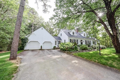
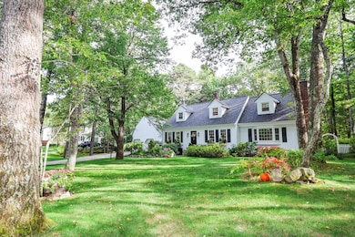
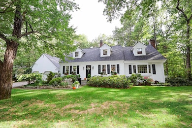
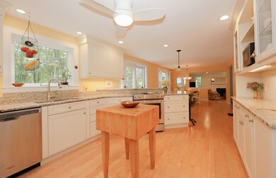
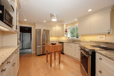
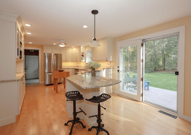
Nestled on a beautifully landscaped, level corner lot that backs onto serene conservation land with walking trails, this inviting Cape-style home offers the perfect blend of comfort, style, and convenience. Step inside through the mudroom to an abundance of natural light and a welcoming, open-concept layout. The spacious kitchen and dining area seamlessly flow into a stunning front-to-back family room featuring a cozy fireplace—perfect for gatherings or quiet evenings at home. From here, you can step outside to a beautiful covered porch or, if you choose an uncovered deck, to sip your morning coffee and enjoy the private backyard full of perennial gardens. Also on the first level, you’ll find a living room and a versatile bedroom—ideal as a guest room, home office, or playroom—along with a 3⁄4 bath and convenient first-floor laundry. Upstairs, the primary suite provides a peaceful retreat, featuring a walk-in closet and a private en-suite bathroom. Two additional generously sized bedrooms and a full bath complete the second floor, all with hardwood flooring. The partially finished basement provides even more space for a rec room, home gym, or additional storage. This home truly has it all—space, privacy, and a picturesque setting—while still being close to everything you need in an award-winning school district. Don’t miss the opportunity to make this beautiful property your own!
Last Agent to Sell the Property
Keller Williams Realty-Metropolitan Listed on: 09/18/2025
| Date | Type | Sale Price | Title Company |
|---|---|---|---|
| Warranty Deed | $190,000 | -- |
| Date | Status | Loan Amount | Loan Type |
|---|---|---|---|
| Open | $97,000 | Unknown | |
| Closed | $50,000 | Unknown | |
| Closed | $119,000 | Unknown | |
| Closed | $152,000 | No Value Available |
| Date | Event | Price | List to Sale | Price per Sq Ft |
|---|---|---|---|---|
| 10/31/2025 10/31/25 | Sold | $750,000 | +3.4% | $265 / Sq Ft |
| 09/22/2025 09/22/25 | Pending | -- | -- | -- |
| 09/18/2025 09/18/25 | For Sale | $725,000 | -- | $256 / Sq Ft |
| Year | Tax Paid | Tax Assessment Tax Assessment Total Assessment is a certain percentage of the fair market value that is determined by local assessors to be the total taxable value of land and additions on the property. | Land | Improvement |
|---|---|---|---|---|
| 2024 | $11,612 | $506,400 | $141,300 | $365,100 |
| 2023 | $11,080 | $506,400 | $141,300 | $365,100 |
| 2022 | $10,696 | $506,200 | $141,300 | $364,900 |
| 2021 | $10,787 | $506,200 | $141,300 | $364,900 |
| 2020 | $9,874 | $346,700 | $113,000 | $233,700 |
| 2019 | $9,344 | $346,600 | $113,000 | $233,600 |
| 2018 | $9,438 | $346,600 | $113,000 | $233,600 |
| 2017 | $9,015 | $346,600 | $113,000 | $233,600 |
| 2016 | $8,700 | $346,600 | $113,000 | $233,600 |
| 2015 | $8,272 | $312,400 | $122,000 | $190,400 |
| 2014 | $8,329 | $312,400 | $122,000 | $190,400 |
| 2013 | $8,155 | $308,300 | $122,000 | $186,300 |
Seller's Agent in 2025
Cinda Celio
Keller Williams Realty-Metropolitan
(603) 512-1308
1 in this area
34 Total Sales
Seller Co-Listing Agent in 2025
Jim Fitzgerald
Keller Williams Realty-Metropolitan
(603) 494-2516
3 in this area
34 Total Sales
Buyer's Agent in 2025
Dan O`Donnell
Keller Williams Gateway Realty
(603) 494-2569
2 in this area
89 Total Sales
Source: PrimeMLS
MLS Number: 5061896
APN: AMHS-000002-000087-000027
Disclaimer: Certain information contained herein is derived from information provided by parties other than Homes.com. All information provided is deemed reliable, but is not guaranteed to be accurate and should be independently verified.
![]() Copyright 2025 PrimeMLS, Inc. All rights reserved. This information is deemed reliable, but not guaranteed. The data relating to real estate displayed on this display comes in part from the IDX Program of PrimeMLS. The information being provided is for consumers’ personal, non-commercial use and may not be used for any purpose other than to identify prospective properties consumers may be interested in purchasing.
Copyright 2025 PrimeMLS, Inc. All rights reserved. This information is deemed reliable, but not guaranteed. The data relating to real estate displayed on this display comes in part from the IDX Program of PrimeMLS. The information being provided is for consumers’ personal, non-commercial use and may not be used for any purpose other than to identify prospective properties consumers may be interested in purchasing.