Estimated Value: $334,000 - $375,000
Studio
--
Bath
1,980
Sq Ft
$178/Sq Ft
Est. Value
About This Home
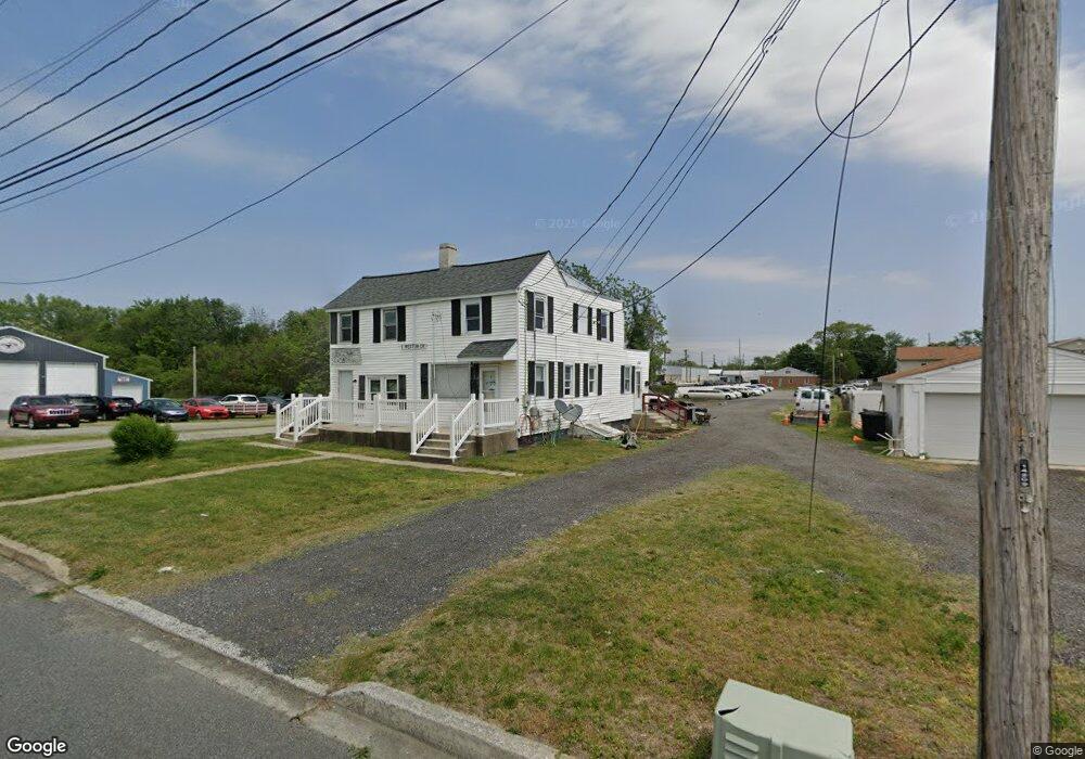
This home is located at 1 Weston Dr, Dover, DE 19904 and is currently estimated at $352,485, approximately $178 per square foot. 1 Weston Dr is a home located in Kent County with nearby schools including Booker T. Washington Elementary School, William Henry Middle School, and Central Middle School.
Ownership History
Date
Name
Owned For
Owner Type
Purchase Details
Closed on
Sep 15, 2025
Sold by
Bennie L Smith Real Estate Llc
Bought by
All Safe Mini Storage Llc
Current Estimated Value
Purchase Details
Closed on
Jun 1, 2016
Sold by
Smith Bennie L and Smith Shirley M
Bought by
Bennie L Smith Real Estate Llc
Purchase Details
Closed on
Aug 9, 2012
Sold by
Smith Bennie L and Smith Shirley M
Bought by
Smith Bennie L and Smith Shirley M
Create a Home Valuation Report for This Property
The Home Valuation Report is an in-depth analysis detailing your home's value as well as a comparison with similar homes in the area
Home Values in the Area
Average Home Value in this Area
Purchase History
| Date | Buyer | Sale Price | Title Company |
|---|---|---|---|
| All Safe Mini Storage Llc | $320,000 | None Listed On Document | |
| All Safe Mini Storage Llc | $320,000 | None Listed On Document | |
| Bennie L Smith Real Estate Llc | -- | Attorney | |
| Bennie L Smith Real Estate Llc | -- | Attorney | |
| Smith Bennie L | -- | None Available | |
| Smith Bennie L | -- | None Available |
Source: Public Records
Tax History
| Year | Tax Paid | Tax Assessment Tax Assessment Total Assessment is a certain percentage of the fair market value that is determined by local assessors to be the total taxable value of land and additions on the property. | Land | Improvement |
|---|---|---|---|---|
| 2025 | $2,289 | $389,400 | $141,400 | $248,000 |
| 2024 | $2,210 | $389,400 | $141,400 | $248,000 |
| 2023 | $1,463 | $49,700 | $9,800 | $39,900 |
| 2022 | $1,414 | $49,700 | $9,800 | $39,900 |
| 2021 | $1,362 | $49,700 | $9,800 | $39,900 |
| 2020 | $1,316 | $49,700 | $9,800 | $39,900 |
| 2019 | $1,244 | $49,700 | $9,800 | $39,900 |
| 2018 | $1,136 | $49,700 | $9,800 | $39,900 |
| 2017 | $1,116 | $49,700 | $0 | $0 |
| 2016 | $1,121 | $49,700 | $0 | $0 |
| 2015 | $1,120 | $49,700 | $0 | $0 |
| 2014 | $1,928 | $49,700 | $0 | $0 |
Source: Public Records
Map
Nearby Homes
- 120 N Kirkwood St
- 120 Reese St
- 824 Slaughter St
- 118 N Queen St
- 130 N Queen St
- 28 S Queen St
- 24 S Queen St
- 305 W Reed St
- 25 S New St
- 209 N New St
- 28 S Governors Ave
- 311 N New St
- 40 S Governors Ave
- 118 W Division St
- 527 William St
- 40 S Bradford St
- 52 Eiger Ct
- 122 S Bradford St
- 520 Fairview Ave
- 10 N State St
- 801 W Division St
- 731 W Division St
- 721 W Division St
- 871 Forest St
- 717 W Division St
- 726 W Division St
- 0 Forest St Unit 1007433528
- 0 Forest St Unit 1006315238
- 0 Forest St Unit 7021245
- 0 Forest St Unit 5314899
- 0 Forest St Unit 6605847
- 0 Forest St Unit 6657657
- 834 Forest St
- 815 Forest St
- 844 Forest St
- 848 Forest St
- 629 W Division St
- 856 Forest St
- 641 Fulton St
- 606 Ridgey St
Your Personal Tour Guide
Ask me questions while you tour the home.