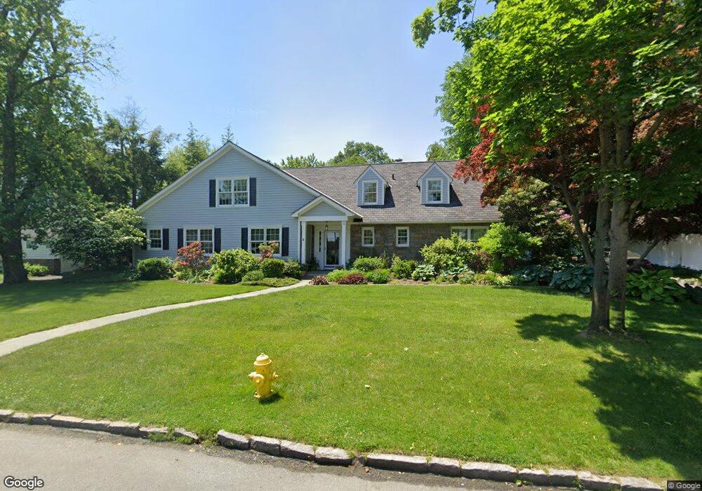
10 Bates Rd Harrison, NY 10528
Estimated Value: $1,629,916 - $2,241,000
2
Beds
3
Baths
2,807
Sq Ft
$665/Sq Ft
Est. Value
About This Home
This home is located at 10 Bates Rd, Harrison, NY 10528 and is currently estimated at $1,867,729, approximately $665 per square foot. 10 Bates Rd is a home located in Westchester County with nearby schools including Harrison Avenue Elementary School, Louis M. Klein Middle School, and Harrison High School.
Ownership History
Date
Name
Owned For
Owner Type
Purchase Details
Closed on
Apr 16, 2002
Sold by
Petti Norman A
Bought by
Cipriani Ralph J and Cipriani Andrea D
Current Estimated Value
Home Financials for this Owner
Home Financials are based on the most recent Mortgage that was taken out on this home.
Original Mortgage
$621,600
Interest Rate
6.8%
Mortgage Type
Purchase Money Mortgage
Purchase Details
Closed on
Nov 30, 2001
Sold by
Straube Christopher
Bought by
Payson Carla F
Purchase Details
Closed on
Aug 26, 1999
Sold by
Petti Norman A and Petti Bernadette
Bought by
Petti Norman A
Home Financials for this Owner
Home Financials are based on the most recent Mortgage that was taken out on this home.
Original Mortgage
$450,000
Interest Rate
8.18%
Mortgage Type
Unknown
Create a Home Valuation Report for This Property
The Home Valuation Report is an in-depth analysis detailing your home's value as well as a comparison with similar homes in the area
Home Values in the Area
Average Home Value in this Area
Purchase History
| Date | Buyer | Sale Price | Title Company |
|---|---|---|---|
| Cipriani Ralph J | $777,000 | First American Title Ins Co | |
| Payson Carla F | $240,000 | Stewart Title Insurance Co | |
| Petti Norman A | -- | Chicago Title Insurance Co | |
| Petti Norman A | $750,000 | First American Title Ins Co |
Source: Public Records
Mortgage History
| Date | Status | Borrower | Loan Amount |
|---|---|---|---|
| Previous Owner | Cipriani Ralph J | $621,600 | |
| Previous Owner | Petti Norman A | $450,000 |
Source: Public Records
Tax History
| Year | Tax Paid | Tax Assessment Tax Assessment Total Assessment is a certain percentage of the fair market value that is determined by local assessors to be the total taxable value of land and additions on the property. | Land | Improvement |
|---|---|---|---|---|
| 2024 | $28,653 | $17,250 | $2,000 | $15,250 |
| 2023 | $31,229 | $17,250 | $2,000 | $15,250 |
| 2022 | $26,984 | $17,250 | $2,000 | $15,250 |
| 2021 | $26,464 | $17,250 | $2,000 | $15,250 |
| 2020 | $30,588 | $17,250 | $2,000 | $15,250 |
| 2019 | $30,654 | $18,900 | $2,000 | $16,900 |
| 2018 | $18,989 | $18,900 | $2,000 | $16,900 |
| 2017 | $0 | $18,900 | $2,000 | $16,900 |
| 2016 | $28,998 | $18,900 | $2,000 | $16,900 |
| 2015 | -- | $18,900 | $2,000 | $16,900 |
| 2014 | -- | $18,900 | $2,000 | $16,900 |
| 2013 | -- | $18,900 | $2,000 | $16,900 |
Source: Public Records
Map
Nearby Homes
- 37 Bates Rd
- 480 Halstead Ave Unit 5M
- 480 Halstead Ave Unit 4V
- 470 Halstead Ave Unit 4G
- 470 Halstead Ave Unit 6V
- 470 Halstead Ave Unit 2T
- 16 Boxwood Ln
- 11 Boxwood Ln
- 60 Holland St
- 120 Old Post Rd Unit PH-B301
- 9 Indian Trail
- 17 Boxwood Ln
- 15 Archer Rd
- 6 Marion Ave
- 76 Glen Oaks Dr
- 40 Oak St
- 50 Franklin Ave
- 10 Beaver Landing
- 1 Ellen Ct
- 6 Pine Ln
Your Personal Tour Guide
Ask me questions while you tour the home.