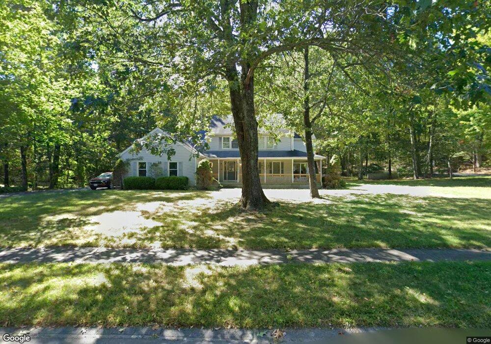
10 Beauregard Terrace West Springfield, MA 01089
Estimated Value: $605,821 - $645,000
4
Beds
3
Baths
2,664
Sq Ft
$233/Sq Ft
Est. Value
About This Home
This home is located at 10 Beauregard Terrace, West Springfield, MA 01089 and is currently estimated at $619,940, approximately $232 per square foot. 10 Beauregard Terrace is a home located in Hampden County with nearby schools including West Springfield High School and Holyoke Community Charter School.
Ownership History
Date
Name
Owned For
Owner Type
Purchase Details
Closed on
Dec 16, 2004
Sold by
Dupuis Diana and Panetta Diana
Bought by
Panetta Diana
Current Estimated Value
Purchase Details
Closed on
Jul 24, 2001
Sold by
Gregitis Joseph F and Gregitis Susan T
Bought by
Dupuis Diana
Purchase Details
Closed on
Feb 25, 1993
Sold by
Beauregard George N and Fanti Roy
Bought by
Gregitis Joseph F and Gregitis Susan T
Create a Home Valuation Report for This Property
The Home Valuation Report is an in-depth analysis detailing your home's value as well as a comparison with similar homes in the area
Home Values in the Area
Average Home Value in this Area
Purchase History
| Date | Buyer | Sale Price | Title Company |
|---|---|---|---|
| Panetta Diana | -- | -- | |
| Dupuis Diana | $320,000 | -- | |
| Gregitis Joseph F | $55,000 | -- |
Source: Public Records
Mortgage History
| Date | Status | Borrower | Loan Amount |
|---|---|---|---|
| Open | Gregitis Joseph F | $185,000 | |
| Closed | Gregitis Joseph F | $165,000 | |
| Previous Owner | Gregitis Joseph F | $50,000 |
Source: Public Records
Tax History Compared to Growth
Tax History
| Year | Tax Paid | Tax Assessment Tax Assessment Total Assessment is a certain percentage of the fair market value that is determined by local assessors to be the total taxable value of land and additions on the property. | Land | Improvement |
|---|---|---|---|---|
| 2025 | $7,762 | $522,000 | $139,800 | $382,200 |
| 2024 | $7,362 | $497,100 | $145,800 | $351,300 |
| 2023 | $7,316 | $470,800 | $164,100 | $306,700 |
| 2022 | $6,484 | $411,400 | $149,100 | $262,300 |
| 2021 | $6,799 | $402,300 | $157,500 | $244,800 |
| 2020 | $6,823 | $401,600 | $157,500 | $244,100 |
| 2019 | $6,811 | $401,600 | $157,500 | $244,100 |
| 2018 | $6,847 | $401,600 | $157,500 | $244,100 |
| 2017 | $6,847 | $401,600 | $157,500 | $244,100 |
| 2016 | $7,212 | $424,500 | $169,800 | $254,700 |
| 2015 | $7,068 | $416,000 | $166,200 | $249,800 |
| 2014 | $1,720 | $416,000 | $166,200 | $249,800 |
Source: Public Records
Map
Nearby Homes
- 59 Clayton Dr
- 11 Annie's Way
- 12 Victorian Dr
- 39 Bonnie Brae Dr
- 26 Clayton Dr
- 36 Susan Dr
- 89-111 Whitney Ave
- lot b Homestead Ave
- 59 Beech Hill Rd
- 75 Birnie Ave
- 86 Birnie Ave
- 34 High Meadow Dr
- 114 Connecticut Ave
- 80 Brush Hill Ave Unit 35
- 80 Brush Hill Ave Unit 28
- 80 Brush Hill Ave Unit 32
- 397 Apremont Hwy
- 351 Apremont Hsy
- 43 Wishing Well Way
- 64 Apple Ridge Rd
- 6 Longfellow Dr
- 919 Prospect Ave
- 936 Prospect Ave
- 20 Longfellow Dr
- 35 Beauregard Terrace
- 905 Prospect Ave
- 36 Beauregard Terrace
- 950 Prospect Ave
- 7 Sean Louis Cir
- 23 Longfellow Dr
- 34 Longfellow Dr
- 901 Prospect Ave
- 54 Beauregard Terrace
- 55 Beauregard Terrace
- 21 Sean Louis Cir
- 877 Prospect Ave
- 8 Sean Louis Cir
- 35 Sean Louis Cir
- 24 Sean Louis Cir
- 861 Prospect Ave