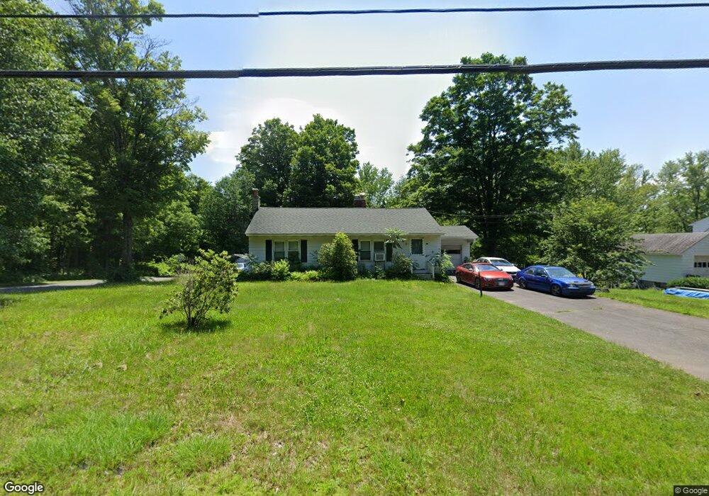
10 Main Rd Gill, MA 01354
Gill NeighborhoodEstimated Value: $265,000 - $319,000
2
Beds
1
Bath
1,058
Sq Ft
$275/Sq Ft
Est. Value
About This Home
This home is located at 10 Main Rd, Gill, MA 01354 and is currently estimated at $290,591, approximately $274 per square foot. 10 Main Rd is a home located in Franklin County with nearby schools including Turners Fall High School, Holy Trinity School, and Four Winds School.
Ownership History
Date
Name
Owned For
Owner Type
Purchase Details
Closed on
Mar 28, 2018
Sold by
Pdv Inc
Bought by
Siano Daniel S
Current Estimated Value
Home Financials for this Owner
Home Financials are based on the most recent Mortgage that was taken out on this home.
Original Mortgage
$157,140
Outstanding Balance
$134,949
Interest Rate
4.38%
Mortgage Type
New Conventional
Estimated Equity
$155,642
Purchase Details
Closed on
Jan 31, 2018
Sold by
Plausky Elizabeth F
Bought by
Pdv Inc
Home Financials for this Owner
Home Financials are based on the most recent Mortgage that was taken out on this home.
Original Mortgage
$157,140
Outstanding Balance
$134,949
Interest Rate
4.38%
Mortgage Type
New Conventional
Estimated Equity
$155,642
Purchase Details
Closed on
Jul 29, 1999
Sold by
Kuzontkoski Frances
Bought by
Plausky Thomas E and Plausky Elizabeth F
Home Financials for this Owner
Home Financials are based on the most recent Mortgage that was taken out on this home.
Original Mortgage
$97,920
Interest Rate
7.61%
Mortgage Type
Purchase Money Mortgage
Create a Home Valuation Report for This Property
The Home Valuation Report is an in-depth analysis detailing your home's value as well as a comparison with similar homes in the area
Home Values in the Area
Average Home Value in this Area
Purchase History
| Date | Buyer | Sale Price | Title Company |
|---|---|---|---|
| Siano Daniel S | $162,000 | -- | |
| Pdv Inc | $100,000 | -- | |
| Plausky Thomas E | $96,000 | -- |
Source: Public Records
Mortgage History
| Date | Status | Borrower | Loan Amount |
|---|---|---|---|
| Open | Siano Daniel S | $157,140 | |
| Previous Owner | Plausky Thomas E | $149,211 | |
| Previous Owner | Plausky Thomas E | $104,502 | |
| Previous Owner | Plausky Thomas E | $99,000 | |
| Previous Owner | Plausky Thomas E | $97,920 |
Source: Public Records
Tax History
| Year | Tax Paid | Tax Assessment Tax Assessment Total Assessment is a certain percentage of the fair market value that is determined by local assessors to be the total taxable value of land and additions on the property. | Land | Improvement |
|---|---|---|---|---|
| 2025 | $3,029 | $206,600 | $50,000 | $156,600 |
| 2024 | $2,859 | $184,700 | $45,400 | $139,300 |
| 2023 | $2,736 | $164,200 | $41,300 | $122,900 |
| 2022 | $2,736 | $164,200 | $41,300 | $122,900 |
| 2021 | $2,740 | $158,500 | $41,300 | $117,200 |
| 2020 | $2,629 | $152,400 | $41,300 | $111,100 |
| 2019 | $2,468 | $143,000 | $39,300 | $103,700 |
| 2018 | $2,373 | $138,100 | $39,300 | $98,800 |
| 2017 | $2,290 | $138,100 | $39,300 | $98,800 |
| 2016 | $2,475 | $146,900 | $52,000 | $94,900 |
| 2015 | $2,433 | $144,400 | $52,000 | $92,400 |
Source: Public Records
Map
Nearby Homes
- 20 Walnut St
- 52 Canada Hill Rd
- 0 Millers Falls Rd Unit 73034825
- 45 Millers Falls Rd
- 001 Adams Rd
- 63 Davis St
- 8 Country Club Ln
- 2 Alice St
- 182 Main Rd
- 23 Sunset Dr
- 805 Fairway Ave
- 696 Bernardston Rd
- 0 French King Hwy
- 709 Fairway Ave
- 183 Millers Falls Rd
- 372 Federal St
- 61 Randall Wood Dr
- 335 Federal St
- 77 Summer St
- 37 Cleveland St
Your Personal Tour Guide
Ask me questions while you tour the home.