
Seller's Agent in 2025
Douglas Ledewitz
Pulse Realty LLC
(203) 305-5282
1 in this area
155 Total Sales
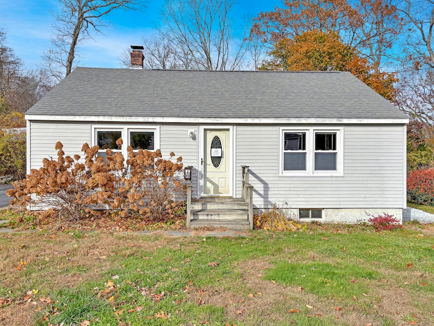
Do not miss 10 Rocky Ledge Dr, located in a mid-century Clinton neighborhood characterized by predominantly 1950s single-family homes on modest lots with convenient access to shopping, dining, and shoreline amenities. This classic ranch/cape offers a practical main-floor layout with two bedrooms, a full bath, a comfortable living room, hardwood and laminate floors, and a large kitchen. A finished attic provides two additional rooms (possible bedrooms?), creating flexible space for a variety of uses. The property also includes a large rear deck and driveway. The house needs TLC and updating, offering a strong opportunity for improvements tailored to individual preferences while benefiting from a mature, well-located neighborhood environment. Property was built prior to 1978; Lead-Based Paint potentially exists. This property may qualify for Seller Financing (Vendee). Town assessor shows two bedrooms and a finished walk-up attic. These 2 additional rooms are possibly convertible to bedrooms. Buyers are advised to perform their due diligence. Sold as-is.
Last Agent to Sell the Property
Pulse Realty LLC Brokerage Phone: (203) 305-5282 License #REB.0759199 Listed on: 11/17/2025
| Date | Type | Sale Price | Title Company |
|---|---|---|---|
| Warranty Deed | $255,950 | -- | |
| Warranty Deed | -- | -- | |
| Warranty Deed | -- | -- | |
| Warranty Deed | $203,000 | -- | |
| Warranty Deed | $203,000 | -- | |
| Warranty Deed | $265,000 | -- | |
| Warranty Deed | $265,000 | -- | |
| Deed | $136,000 | -- |
| Date | Status | Loan Amount | Loan Type |
|---|---|---|---|
| Previous Owner | $207,364 | Purchase Money Mortgage | |
| Previous Owner | $13,750 | Purchase Money Mortgage |
| Date | Event | Price | List to Sale | Price per Sq Ft |
|---|---|---|---|---|
| 12/30/2025 12/30/25 | Sold | $255,950 | -1.0% | $209 / Sq Ft |
| 12/19/2025 12/19/25 | Pending | -- | -- | -- |
| 12/19/2025 12/19/25 | For Sale | $258,500 | +1.0% | $211 / Sq Ft |
| 12/05/2025 12/05/25 | Off Market | $255,950 | -- | -- |
| 11/26/2025 11/26/25 | Pending | -- | -- | -- |
| 11/17/2025 11/17/25 | For Sale | $258,500 | -- | $211 / Sq Ft |
| Year | Tax Paid | Tax Assessment Tax Assessment Total Assessment is a certain percentage of the fair market value that is determined by local assessors to be the total taxable value of land and additions on the property. | Land | Improvement |
|---|---|---|---|---|
| 2025 | $4,039 | $129,700 | $40,900 | $88,800 |
| 2024 | $3,925 | $129,700 | $40,900 | $88,800 |
| 2023 | $3,869 | $129,700 | $40,900 | $88,800 |
| 2022 | $3,869 | $129,700 | $40,900 | $88,800 |
| 2021 | $3,496 | $117,200 | $39,300 | $77,900 |
| 2020 | $3,663 | $117,200 | $39,300 | $77,900 |
| 2019 | $3,663 | $117,200 | $39,300 | $77,900 |
| 2018 | $3,579 | $117,200 | $39,300 | $77,900 |
| 2017 | $3,505 | $117,200 | $39,300 | $77,900 |
| 2016 | $3,181 | $117,200 | $39,300 | $77,900 |
| 2015 | $3,357 | $125,400 | $43,600 | $81,800 |
| 2014 | $3,294 | $125,400 | $43,600 | $81,800 |
Seller's Agent in 2025
Douglas Ledewitz
Pulse Realty LLC
(203) 305-5282
1 in this area
155 Total Sales
K
Seller Co-Listing Agent in 2025
Kristen Glifort
Pulse Realty LLC
(203) 623-3173
1 in this area
16 Total Sales
Buyer's Agent in 2025
Matt Diamond
Houlihan Lawrence WD
(860) 391-9461
6 in this area
52 Total Sales
Source: SmartMLS
MLS Number: 24140831
APN: CLIN-000030-000022-000033
Disclaimer: Certain information contained herein is derived from information provided by parties other than Homes.com. All information provided is deemed reliable, but is not guaranteed to be accurate and should be independently verified.
![]() IDX information is provided exclusively for personal, non-commercial use, and may not be used for any purpose other than to identify prospective properties consumers may be interested in purchasing. Information is deemed reliable but not guaranteed.
IDX information is provided exclusively for personal, non-commercial use, and may not be used for any purpose other than to identify prospective properties consumers may be interested in purchasing. Information is deemed reliable but not guaranteed.
Ask me questions while you tour the home.