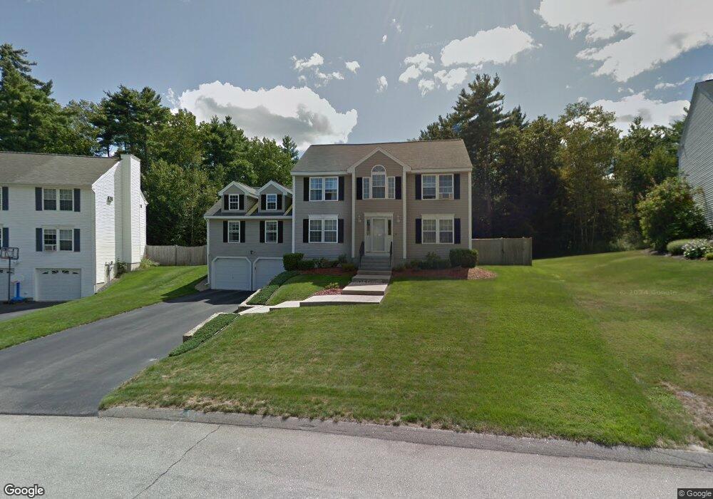
10 Scotchpine Ln MerriMacK, NH 03054
Estimated Value: $634,630 - $702,000
3
Beds
3
Baths
2,721
Sq Ft
$250/Sq Ft
Est. Value
About This Home
This home is located at 10 Scotchpine Ln, MerriMacK, NH 03054 and is currently estimated at $679,158, approximately $249 per square foot. 10 Scotchpine Ln is a home located in Hillsborough County with nearby schools including Thorntons Ferry School, Merrimack Middle School, and James Mastricola Upper Elementary School.
Ownership History
Date
Name
Owned For
Owner Type
Purchase Details
Closed on
May 26, 2016
Sold by
Kane Margaret R
Bought by
Margaret R Kane Ret
Current Estimated Value
Purchase Details
Closed on
Jan 28, 1999
Sold by
Cote Chislaine
Bought by
Kane Brian D and Kane Margaret R
Home Financials for this Owner
Home Financials are based on the most recent Mortgage that was taken out on this home.
Original Mortgage
$115,000
Interest Rate
6.67%
Create a Home Valuation Report for This Property
The Home Valuation Report is an in-depth analysis detailing your home's value as well as a comparison with similar homes in the area
Home Values in the Area
Average Home Value in this Area
Purchase History
Date | Buyer | Sale Price | Title Company |
---|---|---|---|
Margaret R Kane Ret | -- | -- | |
Kane Brian D | $215,000 | -- |
Source: Public Records
Mortgage History
Date | Status | Borrower | Loan Amount |
---|---|---|---|
Previous Owner | Kane Brian D | $81,750 | |
Previous Owner | Kane Brian D | $82,073 | |
Previous Owner | Kane Brian D | $115,000 |
Source: Public Records
Tax History Compared to Growth
Tax History
Year | Tax Paid | Tax Assessment Tax Assessment Total Assessment is a certain percentage of the fair market value that is determined by local assessors to be the total taxable value of land and additions on the property. | Land | Improvement |
---|---|---|---|---|
2024 | $9,559 | $462,000 | $159,600 | $302,400 |
2023 | $8,986 | $462,000 | $159,600 | $302,400 |
2022 | $8,030 | $462,000 | $159,600 | $302,400 |
2021 | $7,907 | $460,500 | $159,600 | $300,900 |
2020 | $8,327 | $346,100 | $122,600 | $223,500 |
2019 | $8,351 | $346,100 | $122,600 | $223,500 |
2018 | $8,348 | $346,100 | $122,600 | $223,500 |
2017 | $8,088 | $346,100 | $122,600 | $223,500 |
2016 | $7,888 | $346,100 | $122,600 | $223,500 |
2015 | $7,535 | $304,800 | $116,900 | $187,900 |
2014 | $7,343 | $304,800 | $116,900 | $187,900 |
2013 | $7,288 | $304,800 | $116,900 | $187,900 |
Source: Public Records
Map
Nearby Homes
- 19 Scotchpine Ln
- 27 Jo Ellen Dr
- 6 Whitetail Ridge
- 7 Den Ave
- 19 Joston Dr
- 5 Jo Ellen Dr
- 7 Joston Dr
- 10 John Ln
- 22 Gray Hawk Rd
- 45 E Ridge Rd Unit B2
- 15 Fox Meadow Ln
- 3A E Ridge Rd
- 21 Pondview Dr
- 40 Abenaki Cir
- 14 Turnbuckle Ln Unit 31
- 33 Currier Rd
- 1 Beech St
- 12 Conifer St
- 19 Turkey Hill Rd
- 15 McElwain St
- 10 Scotchpine Ln
- 8 Scotchpine Ln
- 12 Scotchpine Ln
- 6 Scotchpine Ln
- 14 Scotchpine Ln
- 7 Scotchpine Ln
- 16 Scotchpine Ln
- 4 Scotchpine Ln
- 16 Scotch Pine Ln
- 9 Scotchpine Ln
- 18 Scotchpine Ln
- 11 Scotchpine Ln
- 11 Wintergreen Dr
- 15 Scotchpine Ln
- 17 Scotchpine Ln
- 15 Wintergreen Dr
- 16 Cross St
- 17 Wintergreen Dr
- 10 Wintergreen Dr
- 12 Wintergreen Dr