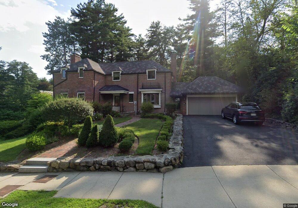
10 Sherbourne St Unit 1 Andover, MA 01810
Shawsheen Heights NeighborhoodEstimated Value: $1,437,000 - $1,551,000
4
Beds
5
Baths
2,757
Sq Ft
$538/Sq Ft
Est. Value
About This Home
This home is located at 10 Sherbourne St Unit 1, Andover, MA 01810 and is currently estimated at $1,482,802, approximately $537 per square foot. 10 Sherbourne St Unit 1 is a home located in Essex County with nearby schools including West Elementary School, Andover West Middle School, and Andover High School.
Ownership History
Date
Name
Owned For
Owner Type
Purchase Details
Closed on
Aug 31, 2022
Sold by
Dimakis Meaghan K and Kosofsky Gregory J
Bought by
Dimakis Kosofsky Lt and Kosofsky
Current Estimated Value
Purchase Details
Closed on
Jun 30, 2020
Sold by
Giordano Miriam and Bertolino Giovanni
Bought by
Dimakis Meaghan K and Kosofsky Gregory J
Home Financials for this Owner
Home Financials are based on the most recent Mortgage that was taken out on this home.
Original Mortgage
$768,000
Interest Rate
3.1%
Mortgage Type
Purchase Money Mortgage
Purchase Details
Closed on
Jun 19, 2019
Sold by
Hunkins Paul S and Norton Jeffrey A
Bought by
Giordano Miriam and Bertolino Giovanni
Home Financials for this Owner
Home Financials are based on the most recent Mortgage that was taken out on this home.
Original Mortgage
$640,500
Interest Rate
4%
Mortgage Type
New Conventional
Purchase Details
Closed on
May 9, 2014
Sold by
Caverly Timothy J and Caverly Isabelle V
Bought by
Hunkins Paul S and Norton Jeffrey A
Home Financials for this Owner
Home Financials are based on the most recent Mortgage that was taken out on this home.
Original Mortgage
$506,525
Interest Rate
4%
Mortgage Type
New Conventional
Purchase Details
Closed on
Oct 30, 1991
Sold by
Pellegrino Joseph P
Bought by
Caverly Timothy J
Create a Home Valuation Report for This Property
The Home Valuation Report is an in-depth analysis detailing your home's value as well as a comparison with similar homes in the area
Home Values in the Area
Average Home Value in this Area
Purchase History
| Date | Buyer | Sale Price | Title Company |
|---|---|---|---|
| Dimakis Kosofsky Lt | -- | None Available | |
| Dimakis Kosofsky Lt | -- | None Available | |
| Dimakis Meaghan K | $960,000 | None Available | |
| Giordano Miriam | $915,000 | -- | |
| Hunkins Paul S | $706,525 | -- | |
| Caverly Timothy J | $285,000 | -- | |
| Caverly Timothy J | $285,000 | -- |
Source: Public Records
Mortgage History
| Date | Status | Borrower | Loan Amount |
|---|---|---|---|
| Previous Owner | Dimakis Meaghan K | $768,000 | |
| Previous Owner | Giordano Miriam | $640,500 | |
| Previous Owner | Hunkins Paul S | $506,525 | |
| Previous Owner | Caverly Timothy J | $195,000 |
Source: Public Records
Tax History Compared to Growth
Tax History
| Year | Tax Paid | Tax Assessment Tax Assessment Total Assessment is a certain percentage of the fair market value that is determined by local assessors to be the total taxable value of land and additions on the property. | Land | Improvement |
|---|---|---|---|---|
| 2024 | $15,192 | $1,179,500 | $540,800 | $638,700 |
| 2023 | $14,619 | $1,070,200 | $487,100 | $583,100 |
| 2022 | $13,880 | $950,700 | $431,200 | $519,500 |
| 2021 | $13,304 | $870,100 | $391,900 | $478,200 |
| 2020 | $12,766 | $850,500 | $382,400 | $468,100 |
| 2019 | $12,610 | $825,800 | $367,500 | $458,300 |
| 2018 | $12,008 | $767,800 | $346,600 | $421,200 |
| 2017 | $11,449 | $754,200 | $339,700 | $414,500 |
| 2016 | $11,158 | $752,900 | $339,700 | $413,200 |
| 2015 | $10,730 | $716,800 | $326,800 | $390,000 |
Source: Public Records
Map
Nearby Homes
- 10 Martingale Ln Unit 10
- 6 Windsor St
- 59 William St
- 24 York St
- 437 N Main St Unit C
- 102 Weare St
- 21 Clubview Dr Unit 21
- 2 Haskell Rd
- 34 Leeds Terrace
- 5 Castle Heights Rd
- 38 Lincoln Cir E
- 5 Marc Ln
- 25 Clubview Dr Unit 25
- 13 Clubview Dr Unit 13
- 5 Lafayette Ave
- 46 Linwood St
- 5 W Kenneth St
- 33 Jefferson St
- 96 Beacon St
- 24 Inman St Unit 32