Estimated Value: $399,467 - $487,000
4
Beds
2
Baths
1,620
Sq Ft
$273/Sq Ft
Est. Value
About This Home
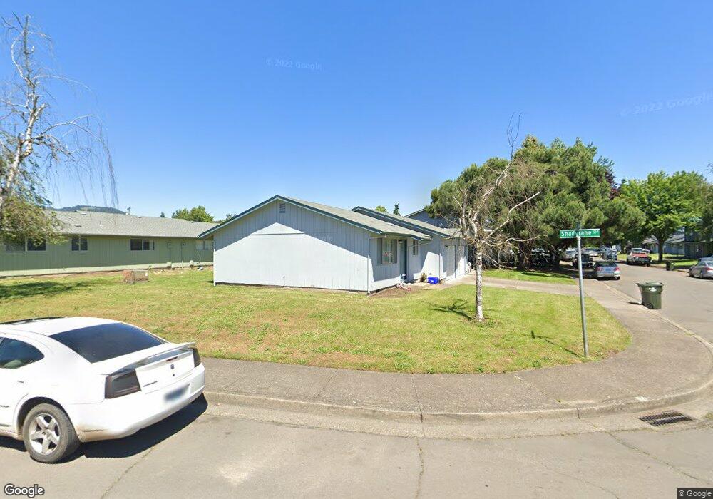
This home is located at 10 U St, Springfield, OR 97477 and is currently estimated at $441,617, approximately $272 per square foot. 10 U St is a home located in Lane County with nearby schools including Elizabeth Page Elementary School, Hamlin Middle School, and Springfield High School.
Ownership History
Date
Name
Owned For
Owner Type
Purchase Details
Closed on
Dec 14, 2005
Sold by
Shepard Charles N
Bought by
Shepard Charles N and The Charles N Shepard Living Trust
Current Estimated Value
Purchase Details
Closed on
Oct 9, 2000
Sold by
Barretto Louis E and Barretto Irma
Bought by
Shepard Charles N
Create a Home Valuation Report for This Property
The Home Valuation Report is an in-depth analysis detailing your home's value as well as a comparison with similar homes in the area
Home Values in the Area
Average Home Value in this Area
Purchase History
| Date | Buyer | Sale Price | Title Company |
|---|---|---|---|
| Shepard Charles N | -- | Western Title & Escrow Compa | |
| Shepard Charles N | $326,000 | Cascade Title Co |
Source: Public Records
Tax History
| Year | Tax Paid | Tax Assessment Tax Assessment Total Assessment is a certain percentage of the fair market value that is determined by local assessors to be the total taxable value of land and additions on the property. | Land | Improvement |
|---|---|---|---|---|
| 2025 | $3,533 | $192,666 | -- | -- |
| 2024 | $3,476 | $187,055 | -- | -- |
| 2023 | $3,476 | $181,607 | $0 | $0 |
| 2022 | $3,219 | $176,318 | $0 | $0 |
| 2021 | $3,161 | $171,183 | $0 | $0 |
| 2020 | $3,069 | $166,198 | $0 | $0 |
| 2019 | $2,977 | $161,358 | $0 | $0 |
| 2018 | $2,806 | $152,096 | $0 | $0 |
| 2017 | $2,698 | $152,096 | $0 | $0 |
| 2016 | $2,642 | $147,666 | $0 | $0 |
| 2015 | $2,543 | $143,365 | $0 | $0 |
| 2014 | $2,475 | $139,189 | $0 | $0 |
Source: Public Records
Map
Nearby Homes
- 126 Woodlane Dr
- 77 Shady Loop
- 2150 Laura St Unit 119
- 2150 Laura St Unit 111
- 2150 Laura St Unit 39
- 2150 Laura St Unit 57
- 2150 Laura St Unit 83
- 2150 Laura St Unit 44
- 2150 Laura (#57) St Unit 57
- 40 Allen Ave
- 212 Hayden Bridge Way
- 364 Scotts Glen Dr
- 421 Woodlane Dr
- 451 Lochaven Ave
- 485 Scotts Glen Dr
- 2136 8th St
- 472 Springdale Ave
- 535 Pacific Ave
- 2268 9th St
- 817 River Knoll Way
Your Personal Tour Guide
Ask me questions while you tour the home.