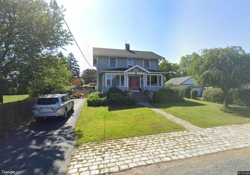
10 Wampatuck Ave Scituate, MA 02066
Estimated Value: $882,000 - $1,018,000
4
Beds
2
Baths
1,736
Sq Ft
$550/Sq Ft
Est. Value
About This Home
This home is located at 10 Wampatuck Ave, Scituate, MA 02066 and is currently estimated at $954,346, approximately $549 per square foot. 10 Wampatuck Ave is a home located in Plymouth County with nearby schools including Wampatuck Elementary School, Lester J. Gates Middle School, and Scituate High School.
Ownership History
Date
Name
Owned For
Owner Type
Purchase Details
Closed on
Oct 20, 2023
Sold by
Dowd Katherine J
Bought by
Dowd Katherine J and Dowd Sean P
Current Estimated Value
Purchase Details
Closed on
Apr 12, 2006
Sold by
Mainini Maria
Bought by
Blanck Katherine
Purchase Details
Closed on
Apr 11, 2005
Sold by
Jacobus John T
Bought by
Mainini Maria
Purchase Details
Closed on
Aug 31, 2000
Sold by
Cohen Richard A and Cohen Alison M
Bought by
Jacobus John T
Purchase Details
Closed on
Mar 30, 1989
Sold by
Stanton Robert J
Bought by
Cohen Richard A
Create a Home Valuation Report for This Property
The Home Valuation Report is an in-depth analysis detailing your home's value as well as a comparison with similar homes in the area
Home Values in the Area
Average Home Value in this Area
Purchase History
| Date | Buyer | Sale Price | Title Company |
|---|---|---|---|
| Dowd Katherine J | -- | None Available | |
| Blanck Katherine | $440,000 | -- | |
| Mainini Maria | $423,000 | -- | |
| Jacobus John T | $293,500 | -- | |
| Cohen Richard A | $181,000 | -- |
Source: Public Records
Mortgage History
| Date | Status | Borrower | Loan Amount |
|---|---|---|---|
| Previous Owner | Cohen Richard A | $341,985 |
Source: Public Records
Tax History Compared to Growth
Tax History
| Year | Tax Paid | Tax Assessment Tax Assessment Total Assessment is a certain percentage of the fair market value that is determined by local assessors to be the total taxable value of land and additions on the property. | Land | Improvement |
|---|---|---|---|---|
| 2025 | $7,814 | $782,200 | $394,500 | $387,700 |
| 2024 | $6,792 | $655,600 | $358,700 | $296,900 |
| 2023 | $6,681 | $600,300 | $326,100 | $274,200 |
| 2022 | $6,387 | $506,100 | $271,900 | $234,200 |
| 2021 | $5,963 | $447,300 | $246,000 | $201,300 |
| 2020 | $5,829 | $431,800 | $236,500 | $195,300 |
| 2019 | $5,763 | $419,400 | $231,900 | $187,500 |
| 2018 | $6,058 | $434,300 | $247,900 | $186,400 |
| 2017 | $5,974 | $424,000 | $237,600 | $186,400 |
| 2016 | $5,612 | $396,900 | $216,900 | $180,000 |
| 2015 | $5,064 | $386,600 | $206,600 | $180,000 |
Source: Public Records
Map
Nearby Homes
- 86 Hatherly Rd
- 23 Oceanside Dr
- 105 Turner Rd
- 32 Barker Rd Unit 3
- 10 Benjamin Ln Unit 10
- 209 Hatherly Rd
- 30 Irving Rd
- 74 Tilden Rd
- 17 Bradford Ave
- 22 Kings Way
- 23 Sunset Rd
- 91 Front St Unit 106
- 378 Tilden Rd
- 50 First Parish Rd
- 54 Woodland Rd
- 111 Elm St
- 3 Grace Way Unit 3
- 1 Grace Way Unit 1
- 115 Elm St
- 59 Captain Peirce Rd