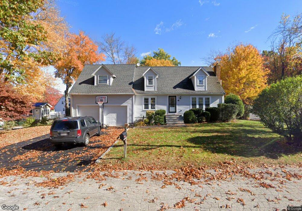
10 Whip o Will Ln Milford, MA 01757
Estimated Value: $637,655 - $747,000
4
Beds
3
Baths
2,097
Sq Ft
$329/Sq Ft
Est. Value
About This Home
This home is located at 10 Whip o Will Ln, Milford, MA 01757 and is currently estimated at $688,914, approximately $328 per square foot. 10 Whip o Will Ln is a home located in Worcester County with nearby schools including Milford High School.
Ownership History
Date
Name
Owned For
Owner Type
Purchase Details
Closed on
Jan 17, 2017
Sold by
Awuku-Asante Daniel
Bought by
Roberts Sherlyn
Current Estimated Value
Purchase Details
Closed on
Aug 31, 2010
Sold by
Malaxechevarria Angel M and Brown Lorraine M
Bought by
Roberts Sherlyn and Awuku-Asante Daniel
Home Financials for this Owner
Home Financials are based on the most recent Mortgage that was taken out on this home.
Original Mortgage
$320,681
Interest Rate
4.25%
Mortgage Type
FHA
Purchase Details
Closed on
Sep 27, 1999
Sold by
Nesta Linda M and Nesta Gregory J
Bought by
Malaxechevarria A M and Brown Lorraine M
Home Financials for this Owner
Home Financials are based on the most recent Mortgage that was taken out on this home.
Original Mortgage
$164,000
Interest Rate
8.1%
Mortgage Type
Purchase Money Mortgage
Purchase Details
Closed on
Jun 28, 1996
Sold by
Filosa David C and Filosa Luann
Bought by
Nesta Gregory and Nesta Linda
Create a Home Valuation Report for This Property
The Home Valuation Report is an in-depth analysis detailing your home's value as well as a comparison with similar homes in the area
Home Values in the Area
Average Home Value in this Area
Purchase History
| Date | Buyer | Sale Price | Title Company |
|---|---|---|---|
| Roberts Sherlyn | -- | -- | |
| Roberts Sherlyn | $325,000 | -- | |
| Malaxechevarria A M | $205,900 | -- | |
| Nesta Gregory | $156,000 | -- |
Source: Public Records
Mortgage History
| Date | Status | Borrower | Loan Amount |
|---|---|---|---|
| Previous Owner | Roberts Sherlyn | $320,681 | |
| Previous Owner | Nesta Gregory | $164,000 | |
| Previous Owner | Nesta Gregory | $144,000 |
Source: Public Records
Tax History Compared to Growth
Tax History
| Year | Tax Paid | Tax Assessment Tax Assessment Total Assessment is a certain percentage of the fair market value that is determined by local assessors to be the total taxable value of land and additions on the property. | Land | Improvement |
|---|---|---|---|---|
| 2025 | $7,473 | $583,800 | $180,400 | $403,400 |
| 2024 | $7,270 | $547,000 | $173,200 | $373,800 |
| 2023 | $7,107 | $491,800 | $149,700 | $342,100 |
| 2022 | $6,764 | $439,500 | $137,100 | $302,400 |
| 2021 | $6,357 | $397,800 | $137,100 | $260,700 |
| 2020 | $6,315 | $395,700 | $137,100 | $258,600 |
| 2019 | $6,446 | $389,700 | $137,100 | $252,600 |
| 2018 | $6,127 | $370,000 | $133,500 | $236,500 |
| 2017 | $5,898 | $351,300 | $133,500 | $217,800 |
| 2016 | $5,718 | $332,800 | $133,500 | $199,300 |
| 2015 | $5,553 | $316,400 | $126,300 | $190,100 |
Source: Public Records
Map
Nearby Homes
- 4 Kennedy Ln Unit 49
- 21 Shadowbrook Ln Unit 13
- 10 Shadowbrook Ln Unit 24
- 4 Shadowbrook Ln Unit 31
- 8 Shadowbrook Ln Unit 39
- 13 Hemlock Ln
- 18 Shadowbrook Ln Unit 40
- 19 Shadowbrook Ln Unit 13
- 11 Shadowbrook Ln Unit 9
- 9 Shadowbrook Ln Unit 27
- 3 Shadowbrook Ln Unit 3
- 5 Shadowbrook Ln Unit 32
- 9 Robin Rd
- 44 Silver Hill Rd
- 1 Tyler St
- 104 Purchase St
- 8 Colonial Rd
- 54 Village Cir Unit 54
- 56 Village Cir
- 250 Congress St