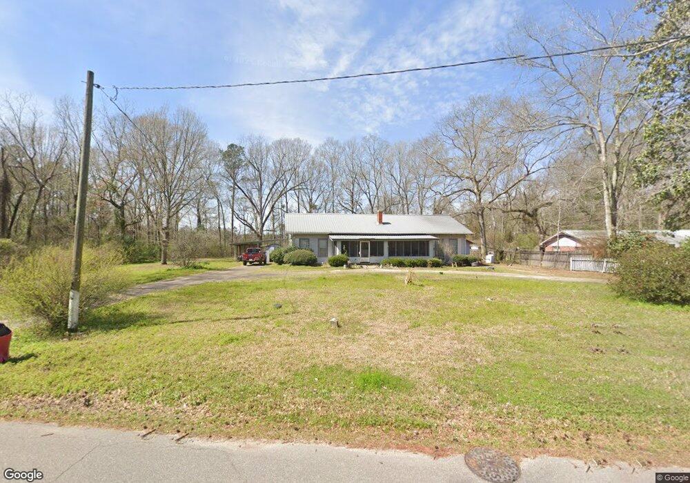
1001 S Main St New Augusta, MS 39462
Estimated Value: $172,000 - $268,000
3
Beds
2
Baths
2,861
Sq Ft
$75/Sq Ft
Est. Value
About This Home
This home is located at 1001 S Main St, New Augusta, MS 39462 and is currently estimated at $213,156, approximately $74 per square foot. 1001 S Main St is a home with nearby schools including Perry Central Middle School and Perry Central High School.
Ownership History
Date
Name
Owned For
Owner Type
Purchase Details
Closed on
Jan 13, 2026
Sold by
Llg Ms Llc
Bought by
Secretary Of Veterans Affairs
Current Estimated Value
Purchase Details
Closed on
Jul 15, 2022
Sold by
Chris Cannon
Bought by
Loper Christopher and Merritt Tiffany L
Home Financials for this Owner
Home Financials are based on the most recent Mortgage that was taken out on this home.
Original Mortgage
$161,634
Interest Rate
5.78%
Mortgage Type
VA
Purchase Details
Closed on
Jul 1, 2022
Sold by
Chris Cannon
Bought by
Loper Christopher and Merritt Tiffany L
Home Financials for this Owner
Home Financials are based on the most recent Mortgage that was taken out on this home.
Original Mortgage
$161,634
Interest Rate
5.78%
Mortgage Type
VA
Purchase Details
Closed on
Jan 2, 2018
Sold by
Cannon Chris
Bought by
Cannon Chris
Create a Home Valuation Report for This Property
The Home Valuation Report is an in-depth analysis detailing your home's value as well as a comparison with similar homes in the area
Purchase History
| Date | Buyer | Sale Price | Title Company |
|---|---|---|---|
| Secretary Of Veterans Affairs | $168,122 | None Listed On Document | |
| Loper Christopher | -- | None Listed On Document | |
| Loper Christopher | -- | None Listed On Document | |
| Cannon Chris | -- | -- |
Source: Public Records
Mortgage History
| Date | Status | Borrower | Loan Amount |
|---|---|---|---|
| Previous Owner | Loper Christopher | $161,634 |
Source: Public Records
Tax History
| Year | Tax Paid | Tax Assessment Tax Assessment Total Assessment is a certain percentage of the fair market value that is determined by local assessors to be the total taxable value of land and additions on the property. | Land | Improvement |
|---|---|---|---|---|
| 2025 | $1,008 | $8,824 | $0 | $0 |
| 2024 | $1,010 | $8,824 | $0 | $0 |
| 2023 | $928 | $8,824 | $0 | $0 |
| 2022 | $900 | $8,824 | $0 | $0 |
| 2021 | $809 | $8,339 | $0 | $0 |
| 2020 | $899 | $9,017 | $0 | $0 |
| 2019 | $1,823 | $13,526 | $0 | $0 |
| 2018 | $1,796 | $13,526 | $0 | $0 |
| 2017 | $1,796 | $12,958 | $0 | $0 |
| 2016 | $164 | $8,673 | $0 | $0 |
| 2015 | $159 | $8,673 | $0 | $0 |
| 2014 | -- | $8,673 | $0 | $0 |
Source: Public Records
Map
Nearby Homes
- 800 S Main St
- 0000 Us Highway 98
- 000 US Highway 98
- 0 US Highway 98
- 0 Highway 29
- 128 Wingate Cove
- 13 River Bottom Rd
- 0 Oneshia Dr Unit 145771
- 00 Hickory Grove Church Rd
- -- US Highway 98
- 702 Vardaman St
- 16 Oneshia Dr
- 0 Locklear Rd Unit 4112785
- 226 Blue Lake Rd
- 80 Ac Farmer Dr
- 0 Hintonville Rd
- 0 Lee Ave
- 01 Horseshoe Ln
- 02 Horseshoe Ln
- 0 O'Banner Loop
Your Personal Tour Guide
Ask me questions while you tour the home.