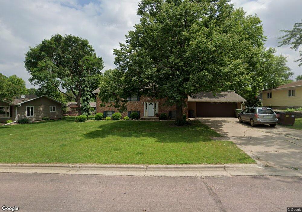
1002 S Carroll St Rock Rapids, IA 51246
Estimated Value: $264,000 - $301,000
3
Beds
3
Baths
1,144
Sq Ft
$247/Sq Ft
Est. Value
About This Home
This home is located at 1002 S Carroll St, Rock Rapids, IA 51246 and is currently estimated at $282,779, approximately $247 per square foot. 1002 S Carroll St is a home located in Lyon County with nearby schools including Central Lyon Elementary School, Central Lyon Senior High School, and Ignite Christian Academy.
Ownership History
Date
Name
Owned For
Owner Type
Purchase Details
Closed on
Oct 15, 2024
Sold by
Roetman Michael L and Roetman Susan J
Bought by
Sinnett Steven and Sinnett Heather
Current Estimated Value
Home Financials for this Owner
Home Financials are based on the most recent Mortgage that was taken out on this home.
Original Mortgage
$76,000
Interest Rate
6.64%
Mortgage Type
New Conventional
Purchase Details
Closed on
Jan 18, 2018
Sold by
Roetman Michael L and Roetman Tr David J
Bought by
Roetman Michael L
Create a Home Valuation Report for This Property
The Home Valuation Report is an in-depth analysis detailing your home's value as well as a comparison with similar homes in the area
Home Values in the Area
Average Home Value in this Area
Purchase History
| Date | Buyer | Sale Price | Title Company |
|---|---|---|---|
| Sinnett Steven | $96,000 | None Listed On Document | |
| Sinnett Steven | $96,000 | None Listed On Document | |
| Roetman Michael L | -- | -- |
Source: Public Records
Mortgage History
| Date | Status | Borrower | Loan Amount |
|---|---|---|---|
| Previous Owner | Sinnett Steven | $76,000 |
Source: Public Records
Tax History Compared to Growth
Tax History
| Year | Tax Paid | Tax Assessment Tax Assessment Total Assessment is a certain percentage of the fair market value that is determined by local assessors to be the total taxable value of land and additions on the property. | Land | Improvement |
|---|---|---|---|---|
| 2025 | $3,306 | $254,190 | $30,550 | $223,640 |
| 2024 | $3,306 | $226,850 | $30,550 | $196,300 |
| 2023 | $3,124 | $226,850 | $30,550 | $196,300 |
| 2022 | $2,774 | $172,700 | $30,550 | $142,150 |
| 2021 | $2,774 | $172,700 | $30,550 | $142,150 |
| 2020 | $3,176 | $168,530 | $30,550 | $137,980 |
| 2019 | $3,350 | $169,420 | $0 | $0 |
| 2018 | $3,286 | $169,420 | $0 | $0 |
| 2017 | $3,286 | $151,770 | $0 | $0 |
| 2016 | $2,976 | $151,770 | $0 | $0 |
| 2015 | $2,976 | $156,084 | $0 | $0 |
| 2014 | $3,070 | $156,084 | $0 | $0 |
Source: Public Records
Map
Nearby Homes
- 811 S Carroll St
- 903 S Jansen St
- 706 S 9th Ave
- 1011 S Marshall St
- 707 S Greene St
- 610 S Carroll St
- 1002 S Tama St
- 606 S Carroll St
- 507 S Greene St
- 1100 S 6th Ave
- 204 S 15th Ave
- 1102 S 6th Ave
- 1006 S 6th Ave
- 1002 S 6th Ave
- 1104 S 6th Ave
- 1004 S 6th Ave
- 410 S Union St
- 406 S Adams St
- 307 S Union St
- 206 S Marshall St
- 1004 S Carroll St
- 1000 S Carroll St
- 506 S 10th Ave
- 105 Oleary Ln
- 107 Oleary Ln
- 1006 S Carroll St
- 504 S 10th Ave
- 1005 S Carroll St
- 602 S 10th Ave
- 104 Oleary Ln
- 103 Oleary Ln
- 1009 S Carroll St
- 502 S 10th Ave
- 910 S Carroll St
- 1101 S Carroll St
- 507 S 10th Ave
- 102 Oleary Ln
- 604 S 10th Ave
- 505 S 10th Ave
- 101 Oleary Ln