Estimated Value: $343,196 - $449,000
4
Beds
3
Baths
2,900
Sq Ft
$130/Sq Ft
Est. Value
About This Home
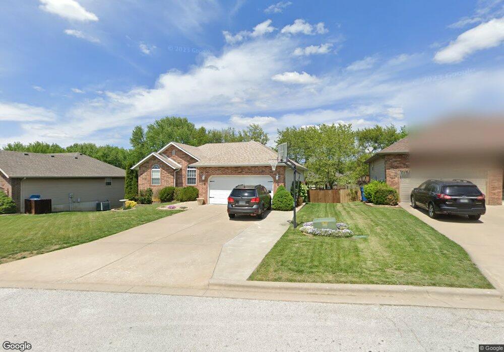
This home is located at 1005 Bates Dr, Nixa, MO 65714 and is currently estimated at $376,049, approximately $129 per square foot. 1005 Bates Dr is a home located in Christian County with nearby schools including Mathews Elementary School, Nicholas A. Inman Intermediate School, and Nixa Junior High School.
Ownership History
Date
Name
Owned For
Owner Type
Purchase Details
Closed on
Oct 28, 2009
Sold by
Robison Jonathan L and Robison Rebecca
Bought by
Thomas Jeffrey and Thomas Diana
Current Estimated Value
Home Financials for this Owner
Home Financials are based on the most recent Mortgage that was taken out on this home.
Original Mortgage
$140,000
Outstanding Balance
$89,450
Interest Rate
4.9%
Mortgage Type
New Conventional
Estimated Equity
$286,599
Purchase Details
Closed on
May 25, 2007
Sold by
Robison K Elizabeth and Robison Karen E
Bought by
Robison Jonathan L
Purchase Details
Closed on
Apr 28, 2005
Sold by
Chapman Matthew J and Chapman Judith E
Bought by
Robison Jonathan L and Elizabeth Robison K
Home Financials for this Owner
Home Financials are based on the most recent Mortgage that was taken out on this home.
Original Mortgage
$133,600
Interest Rate
6.03%
Mortgage Type
New Conventional
Create a Home Valuation Report for This Property
The Home Valuation Report is an in-depth analysis detailing your home's value as well as a comparison with similar homes in the area
Home Values in the Area
Average Home Value in this Area
Purchase History
| Date | Buyer | Sale Price | Title Company |
|---|---|---|---|
| Thomas Jeffrey | -- | None Available | |
| Robison Jonathan L | -- | None Available | |
| Robison Jonathan L | -- | Guaranty Title Company |
Source: Public Records
Mortgage History
| Date | Status | Borrower | Loan Amount |
|---|---|---|---|
| Open | Thomas Jeffrey | $140,000 | |
| Previous Owner | Robison Jonathan L | $133,600 |
Source: Public Records
Tax History
| Year | Tax Paid | Tax Assessment Tax Assessment Total Assessment is a certain percentage of the fair market value that is determined by local assessors to be the total taxable value of land and additions on the property. | Land | Improvement |
|---|---|---|---|---|
| 2025 | $2,298 | $39,270 | -- | -- |
| 2024 | $2,298 | $36,880 | -- | -- |
| 2023 | $2,298 | $36,880 | $0 | $0 |
| 2022 | $2,206 | $35,360 | $0 | $0 |
| 2021 | $2,208 | $35,360 | $0 | $0 |
| 2020 | $1,971 | $30,130 | $0 | $0 |
| 2019 | $1,971 | $30,130 | $0 | $0 |
| 2018 | $1,836 | $30,130 | $0 | $0 |
| 2017 | $1,836 | $30,130 | $0 | $0 |
| 2016 | $1,808 | $30,130 | $0 | $0 |
| 2015 | $1,810 | $30,130 | $30,130 | $0 |
| 2014 | $1,765 | $30,120 | $0 | $0 |
| 2013 | $1,768 | $30,120 | $0 | $0 |
| 2011 | -- | $60,240 | $0 | $0 |
Source: Public Records
Map
Nearby Homes
- 601 S Gregg Rd
- 1257 W Bridgewood Place
- 1202 Glen Oaks Dr
- 891 W Pembrook Ave
- 912 Wesley Ave
- 605 Glen Oaks Cir
- 1266 W Bridgewood Place
- 788 S Hackberry Ave
- 752 W Mimosa Ct
- 1280 W Butterfield Dr
- 721 W Butterfield Dr
- 1109 W Scenic Hills Dr
- 1334 W Mount Vernon St
- 704 W Savanna Ct
- 911 S Silverwood Ln
- 611 W Coventry Rd
- 1319 Woodcastle Rd
- 1209 W Mount Vernon St
- 867 S Irontree Ct
- 982 S Redwood St
Your Personal Tour Guide
Ask me questions while you tour the home.