Estimated payment $11,240/month
Highlights
- Spa
- View of Trees or Woods
- Colonial Architecture
- Wells Elementary School Rated A-
- 4.13 Acre Lot
- Deck
About This Home
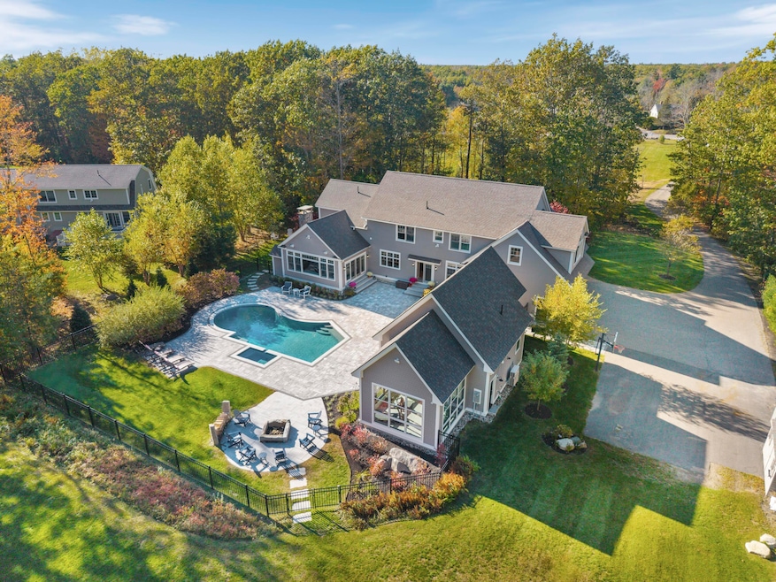
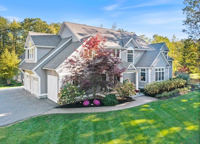
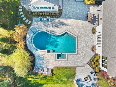
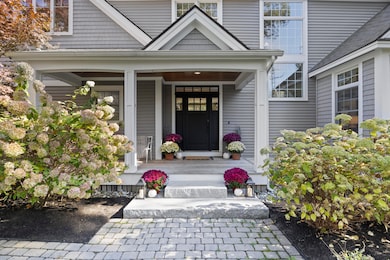
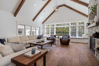
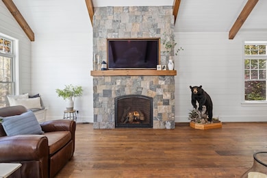
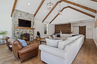
Where luxury meets lifestyle. This extraordinary Wells property delivers a living experience unlike any other. Tucked away on over four acres, this extraordinary estate combines elegance and craftsmanship in one breathtaking setting. The main residence impresses with soaring ceilings, warm wood beams, and a striking stone fireplace that anchors the living spaces. The gourmet kitchen is designed for both beauty and function, featuring a coffered ceiling, oversized island, custom cabinetry, beverage cooler, tile backsplash, and a walk-in pantry with a second wall oven. A sliding barn door opens to the great room where vaulted ceilings and expansive windows create a dramatic yet inviting ambiance. The grand staircase, elegant dining area, oversized mudroom with laundry, and dedicated office space complete the first floor. Upstairs, the primary suite includes two walk-in closets and a beautifully appointed ensuite bath with a tiled shower, jetted tub, and double vanity. Two additional bedrooms, a guest ensuite, and a second laundry room add exceptional comfort and flexibility. Step outside to a backyard designed for entertaining. Granite steps lead to an expansive patio surrounding the heated in-ground pool and built-in hot tub zone. A fire pit area, manicured grounds, and multiple seating areas make this a true retreat. The pool house elevates the experience with vaulted ceilings, a kitchenette, full bath, and a exercise room with floor to ceiling windows that can easily convert into a private suite. The location offers peace and privacy while being close to Nubble Lighthouse, York Beach, Wells Beach and downtown Wells. Experience luxury living in one of Maine's most desirable coastal towns.
Home Details
Home Type
- Single Family
Est. Annual Taxes
- $5,950
Year Built
- Built in 2009
Lot Details
- 4.13 Acre Lot
Parking
- 2 Car Attached Garage
Home Design
- Colonial Architecture
- Shingle Roof
Interior Spaces
- Vaulted Ceiling
- Ceiling Fan
- 1 Fireplace
- Mud Room
- Views of Woods
- Laundry Room
Flooring
- Wood
- Carpet
- Tile
Bedrooms and Bathrooms
- 4 Bedrooms
- Primary bedroom located on second floor
Basement
- Doghouse Basement Entry
- Interior Basement Entry
Outdoor Features
- Spa
- Deck
- Patio
- Shed
- Outbuilding
- Porch
Utilities
- Cooling Available
- Forced Air Heating System
- Heat Pump System
- Baseboard Heating
- Hot Water Heating System
- Underground Utilities
- Private Water Source
- Well
- Septic Design Available
- Private Sewer
Community Details
- No Home Owners Association
Listing and Financial Details
- Tax Lot 7-1
- Assessor Parcel Number WLLS-000070-000007-000000-000001
Map
Home Values in the Area
Average Home Value in this Area
Tax History
| Year | Tax Paid | Tax Assessment Tax Assessment Total Assessment is a certain percentage of the fair market value that is determined by local assessors to be the total taxable value of land and additions on the property. | Land | Improvement |
|---|---|---|---|---|
| 2025 | $9,873 | $1,528,380 | $144,370 | $1,384,010 |
| 2024 | $5,950 | $978,550 | $144,370 | $834,180 |
| 2023 | $5,832 | $978,550 | $144,370 | $834,180 |
| 2022 | $8,033 | $767,950 | $65,580 | $702,370 |
| 2021 | $8,079 | $767,950 | $56,190 | $711,760 |
| 2020 | $8,048 | $767,950 | $65,580 | $702,370 |
| 2019 | $7,999 | $767,700 | $65,580 | $702,120 |
| 2018 | $7,923 | $767,700 | $65,580 | $702,120 |
| 2017 | $7,800 | $767,700 | $65,580 | $702,120 |
| 2016 | $5,129 | $509,800 | $65,580 | $444,220 |
| 2015 | $5,073 | $509,800 | $65,580 | $444,220 |
| 2013 | $4,642 | $509,020 | $65,580 | $443,440 |
Property History
| Date | Event | Price | List to Sale | Price per Sq Ft |
|---|---|---|---|---|
| 02/09/2026 02/09/26 | Price Changed | $1,995,000 | -4.8% | $290 / Sq Ft |
| 12/17/2025 12/17/25 | Price Changed | $2,095,000 | -4.6% | $304 / Sq Ft |
| 10/14/2025 10/14/25 | For Sale | $2,195,000 | -- | $319 / Sq Ft |
Purchase History
| Date | Type | Sale Price | Title Company |
|---|---|---|---|
| Warranty Deed | -- | -- |
Mortgage History
| Date | Status | Loan Amount | Loan Type |
|---|---|---|---|
| Open | $376,000 | Unknown | |
| Closed | $300,000 | Purchase Money Mortgage | |
| Closed | $49,000 | Unknown |
Source: Maine Listings
MLS Number: 1640828
APN: WLLS-000070-000007-000000-000001
Disclaimer: Certain information contained herein is derived from information provided by parties other than Homes.com. All information provided is deemed reliable, but is not guaranteed to be accurate and should be independently verified.
![]() Listing data is derived in whole or in part from Maine Real Estate Information System, Inc. (d/b/a Maine Listings) and is for consumers' personal, noncommercial use only. Dimensions are approximate and not guaranteed. All data should be independently verified.
Listing data is derived in whole or in part from Maine Real Estate Information System, Inc. (d/b/a Maine Listings) and is for consumers' personal, noncommercial use only. Dimensions are approximate and not guaranteed. All data should be independently verified.
© 2026 Maine Real Estate Information System, Inc. All Rights Reserved. Equal Housing Opportunity.
Homes.com, LLC, 17600 Laguna Canyon Rd Irvine, CA 92618 (888)-952-6393
![]()
- 00 Farm View Ln
- Lot 4A Cider Press Ln
- lot 3 Lydias Cir
- 223 Chick Crossing Rd
- lot 20 Lydias Cir
- 222 Hobbs Farm Rd Unit Lot 9
- 222 Hobbs Farm Rd Unit Lot 10
- 222 Hobbs Farm Rd Unit Lot 7
- 222 Hobbs Farm Rd Unit Lot 5
- 222 Hobbs Farm Rd Unit Lot 8
- 1646 Branch Rd
- 160 Millbrooke Farm Dr Unit 160
- 41 Baker Rd
- 44 Baker Rd
- 42 Baker Rd Unit 42
- 42 Baker Rd
- 38 Baker Rd
- 38 Baker Rd Unit 38
- 17 Cascade Cir Unit 19
- 44 Grand Trail Dr Unit 44
- 20 Maguire Rd Unit Maguire
- 12 Bow St Unit 2
- 22 York St Unit 2
- 17 Water St Unit 3
- 22 Fletcher St Unit 22 Fletcher Street
- 10 Windward Ln
- 53 Beach Ave
- 658 Main St Unit 655 Main street ogunquit
- 24 Patriots Ln
- 8 Acorn St Unit A
- 8 Eddy Ave
- 6 Linden Ave
- 11 Folsom Dr Unit 11 Folsom Drive
- 7 Dartmouth St
- 1376 Us Route 1
- 94 Graham St Unit 201
- 598 Main St
- 20 Crescent St Unit 2
- 59 Center St Unit 102
- 1 Summer St

Ask me questions while you tour the home.