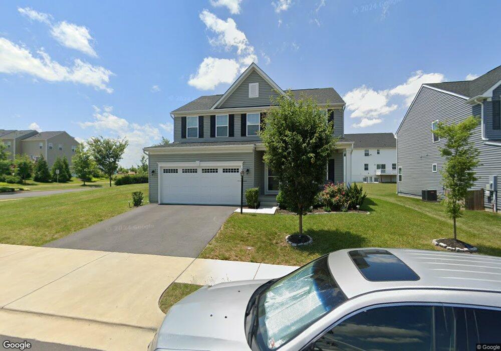
101 Baily Way Stephenson, VA 22656
Stephenson NeighborhoodEstimated Value: $567,000 - $577,000
4
Beds
4
Baths
2,492
Sq Ft
$229/Sq Ft
Est. Value
About This Home
This home is located at 101 Baily Way, Stephenson, VA 22656 and is currently estimated at $571,611, approximately $229 per square foot. 101 Baily Way is a home with nearby schools including Stonewall Elementary School and James Wood Middle School.
Ownership History
Date
Name
Owned For
Owner Type
Purchase Details
Closed on
Dec 23, 2019
Sold by
Nvrt Inc
Bought by
Paige Derrick Keith and Roncal Susan
Current Estimated Value
Home Financials for this Owner
Home Financials are based on the most recent Mortgage that was taken out on this home.
Original Mortgage
$364,150
Outstanding Balance
$321,678
Interest Rate
3.7%
Mortgage Type
New Conventional
Estimated Equity
$249,933
Purchase Details
Closed on
Sep 4, 2019
Sold by
Brookfield Stephenson Village Llc
Bought by
Nvr Inc
Create a Home Valuation Report for This Property
The Home Valuation Report is an in-depth analysis detailing your home's value as well as a comparison with similar homes in the area
Home Values in the Area
Average Home Value in this Area
Purchase History
| Date | Buyer | Sale Price | Title Company |
|---|---|---|---|
| Paige Derrick Keith | $383,355 | Stewart Title Guaranty Co | |
| Nvr Inc | $186,388 | Nvr Settlement Services |
Source: Public Records
Mortgage History
| Date | Status | Borrower | Loan Amount |
|---|---|---|---|
| Open | Paige Derrick Keith | $364,150 |
Source: Public Records
Tax History Compared to Growth
Tax History
| Year | Tax Paid | Tax Assessment Tax Assessment Total Assessment is a certain percentage of the fair market value that is determined by local assessors to be the total taxable value of land and additions on the property. | Land | Improvement |
|---|---|---|---|---|
| 2025 | $2,441 | $508,500 | $93,000 | $415,500 |
| 2024 | $1,130 | $443,100 | $77,000 | $366,100 |
| 2023 | $2,260 | $443,100 | $77,000 | $366,100 |
| 2022 | $2,205 | $361,500 | $72,000 | $289,500 |
| 2021 | $2,205 | $361,500 | $72,000 | $289,500 |
| 2020 | $2,003 | $328,400 | $72,000 | $256,400 |
| 2019 | $397 | $65,000 | $65,000 | $0 |
Source: Public Records
Map
Nearby Homes
- 216 Parkland Dr
- 101 Goshen Place
- 114 Flaxen Mane Ct
- 114 Galaxy Place
- 125 Galaxy Place
- Monroe Plan at Snowden Bridge - Single Family Collection
- Skyline Plan at Snowden Bridge - Townhome Collection
- Sheridan II Plan at Snowden Bridge - Single Family Collection
- Pendleton II Plan at Snowden Bridge - Single Family Collection
- Torrington Plan at Snowden Bridge - Single Family Collection
- Denison Plan at Snowden Bridge - Single Family Collection
- Sinclair Plan at Snowden Bridge - Single Family Collection
- 109 Gelding Way
- 129 Heyford Dr
- 112 Heyford Dr
- 131 Heyford Dr
- 114 Heyford Dr
- 214 Mosaic Ct
- 114 Norland Knoll Dr
- 112 Norland Knoll Dr
- 103 Baily Way
- 500 Parkland Dr
- 100 Seesaw Ct
- 105 Baily Way
- 102 Seesaw Ct
- 201 Parkland Dr
- 104 Seesaw Ct
- 200 Patriot St
- 0060 Crofton Ct
- 205 Parkland Dr
- 0061 Crofton Ct
- 0064 Crofton Ct
- 200 Parkland Dr
- 202 Parkland Dr
- 0063 Crofton Ct
- 202 Patriot St
- 108 Santa fe Ct
- 108 Seesaw Ct
- 103 Patriot St
- 204 Parkland Dr