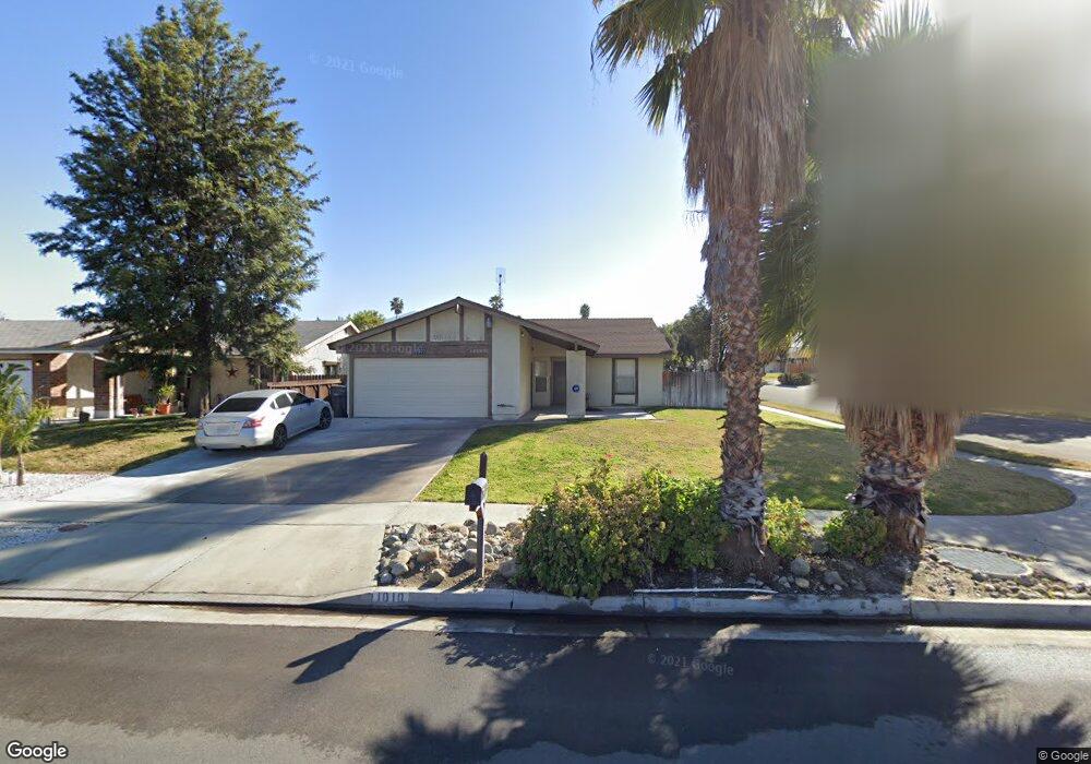
1010 Aaron Dr Redlands, CA 92374
North Redlands NeighborhoodEstimated Value: $539,939 - $640,000
3
Beds
2
Baths
1,466
Sq Ft
$402/Sq Ft
Est. Value
About This Home
This home is located at 1010 Aaron Dr, Redlands, CA 92374 and is currently estimated at $588,985, approximately $401 per square foot. 1010 Aaron Dr is a home located in San Bernardino County with nearby schools including Judson & Brown Elementary School, Clement Middle School, and Redlands East Valley High School.
Ownership History
Date
Name
Owned For
Owner Type
Purchase Details
Closed on
Dec 14, 2012
Sold by
Joseph Jonathan and Joseph Rebecca Joan
Bought by
Citrus Avenue Trust
Current Estimated Value
Purchase Details
Closed on
May 24, 2001
Sold by
Hooyenga James J and Hooyenga Mary Lou
Bought by
Joseph Jonathan and Joseph Rebecca Joan
Home Financials for this Owner
Home Financials are based on the most recent Mortgage that was taken out on this home.
Original Mortgage
$1,400,000
Interest Rate
7.05%
Mortgage Type
Purchase Money Mortgage
Create a Home Valuation Report for This Property
The Home Valuation Report is an in-depth analysis detailing your home's value as well as a comparison with similar homes in the area
Home Values in the Area
Average Home Value in this Area
Purchase History
| Date | Buyer | Sale Price | Title Company |
|---|---|---|---|
| Citrus Avenue Trust | -- | None Available | |
| Date Street Trust | -- | None Available | |
| Wildwood Canyon Road Trust | -- | None Available | |
| Fir Avenue Trust | -- | None Available | |
| Peach Tree Road Trust | -- | None Available | |
| 6Th Place Trust | -- | None Available | |
| Aaron Drive Trust | -- | None Available | |
| Joseph Jonathan | $1,225,000 | First American Title |
Source: Public Records
Mortgage History
| Date | Status | Borrower | Loan Amount |
|---|---|---|---|
| Previous Owner | Joseph Jonathan | $1,400,000 |
Source: Public Records
Tax History
| Year | Tax Paid | Tax Assessment Tax Assessment Total Assessment is a certain percentage of the fair market value that is determined by local assessors to be the total taxable value of land and additions on the property. | Land | Improvement |
|---|---|---|---|---|
| 2025 | $2,598 | $206,826 | $44,320 | $162,506 |
| 2024 | $2,428 | $202,771 | $43,451 | $159,320 |
| 2023 | $2,425 | $198,795 | $42,599 | $156,196 |
| 2022 | $2,390 | $194,897 | $41,764 | $153,133 |
| 2021 | $2,433 | $191,075 | $40,945 | $150,130 |
| 2020 | $2,397 | $189,116 | $40,525 | $148,591 |
| 2019 | $2,331 | $185,407 | $39,730 | $145,677 |
| 2018 | $2,273 | $181,772 | $38,951 | $142,821 |
| 2017 | $2,254 | $178,208 | $38,187 | $140,021 |
| 2016 | $2,229 | $174,713 | $37,438 | $137,275 |
| 2015 | $2,213 | $172,089 | $36,876 | $135,213 |
| 2014 | $2,173 | $168,718 | $36,154 | $132,564 |
Source: Public Records
Map
Nearby Homes
- 936 Judson St
- 917 Renee St
- 1326 Campus Ave
- 1322 Campus Ave
- 450 Judson St Unit 94
- 927 Knightsbridge Ln
- 0 E Lugonia Ave
- 455 Judson St Unit 9
- 1317 Susan Ave
- 259 East Dr
- 1251 E Lugonia Ave Unit 109
- 1251 E Lugonia Ave Unit 27
- 1251 E Lugonia Ave Unit 24
- 1251 E Lugonia Ave Unit 18
- 1251 E Lugonia Ave Unit 75
- 1529 Adeline Ave
- 1174 Benbow Place
- 0 E Colton Ave
- 15 Naomi St
- 1721 E Colton Ave Unit 33
- 1020 Aaron Dr
- 1439 Campus Ave
- 942 Aaron Dr
- 1030 Aaron Dr
- 1440 E Brockton Ave
- 1009 Aaron Dr
- 1443 Campus Ave
- 1019 Aaron Dr
- 943 Aaron Dr
- 938 Aaron Dr
- 1444 E Brockton Ave
- 1031 Aaron Dr
- 1444 Campus Ave
- 939 Aaron Dr
- 1447 Campus Ave
- 934 Aaron Dr
- 1439 Clock St
- 1448 E Brockton Ave
- 1024 Renee St
- 1044 Renee St
Your Personal Tour Guide
Ask me questions while you tour the home.