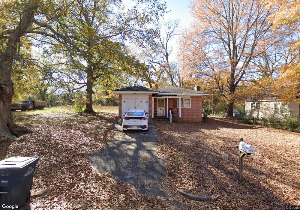
1010 Brock St Anderson, SC 29624
Estimated Value: $84,313 - $117,000
2
Beds
1
Bath
1,050
Sq Ft
$101/Sq Ft
Est. Value
About This Home
This home is located at 1010 Brock St, Anderson, SC 29624 and is currently estimated at $106,078, approximately $101 per square foot. 1010 Brock St is a home located in Anderson County with nearby schools including Nevitt Forest Elementary School, McCants Middle School, and T.L. Hanna High School.
Ownership History
Date
Name
Owned For
Owner Type
Purchase Details
Closed on
Nov 12, 2008
Sold by
Nido Rafael Mariano
Bought by
Hessler Lawrence
Current Estimated Value
Purchase Details
Closed on
Feb 7, 2007
Sold by
Hud
Bought by
Nido Rafael Mariano
Purchase Details
Closed on
Feb 14, 2006
Sold by
Midland Mortgage Co
Bought by
Hud
Purchase Details
Closed on
Jun 17, 2005
Sold by
Hud
Bought by
Mortgageco Midland
Purchase Details
Closed on
Aug 20, 2004
Sold by
Crosby Tommy and Clinkscales Necko
Bought by
Hud
Create a Home Valuation Report for This Property
The Home Valuation Report is an in-depth analysis detailing your home's value as well as a comparison with similar homes in the area
Home Values in the Area
Average Home Value in this Area
Purchase History
| Date | Buyer | Sale Price | Title Company |
|---|---|---|---|
| Hessler Lawrence | $29,000 | -- | |
| Nido Rafael Mariano | $13,500 | None Available | |
| Hud | -- | None Available | |
| Mortgageco Midland | -- | -- | |
| Hud | $2,500 | -- |
Source: Public Records
Tax History Compared to Growth
Tax History
| Year | Tax Paid | Tax Assessment Tax Assessment Total Assessment is a certain percentage of the fair market value that is determined by local assessors to be the total taxable value of land and additions on the property. | Land | Improvement |
|---|---|---|---|---|
| 2024 | $749 | $1,650 | $190 | $1,460 |
| 2023 | $749 | $1,650 | $190 | $1,460 |
| 2022 | $412 | $1,650 | $190 | $1,460 |
| 2021 | $420 | $1,570 | $120 | $1,450 |
| 2020 | $417 | $1,570 | $120 | $1,450 |
| 2019 | $420 | $1,570 | $120 | $1,450 |
| 2018 | $420 | $1,570 | $120 | $1,450 |
| 2017 | -- | $1,570 | $120 | $1,450 |
| 2016 | $435 | $1,620 | $120 | $1,500 |
| 2015 | $437 | $1,620 | $120 | $1,500 |
| 2014 | $433 | $1,620 | $120 | $1,500 |
Source: Public Records
Map
Nearby Homes
- 405 Washington St
- 602 Caughlin Ave
- 1111 E River St
- 106 Riverview Dr
- 1303 E River St
- 910 E Whitner St
- 509 E Hampton St
- 902 E Whitner St
- 525 Fulwer St
- 419 Douglas St
- 404 Short St
- 905 E Whitner St
- 1402 Mitchell St
- 519 Thomas St
- 1308 Roadway St
- 103 Farmer St
- 912 Pickens St
- 306 Broyles St
- 700 Redwood Ave
- 800 Beachwood Ave
- 1008 Brock St
- 1004 Brock St
- 1016 Brock St
- 505 Washington St
- 1009 Elizabeth St
- 1005 Elizabeth St
- 0 Brock St
- 1000 Brock St
- 1018 Brock St
- 1011 Elizabeth St
- 1009 Brock St
- 1011 Brock St
- 1013 Elizabeth St
- 1013 Brock St
- 1003 Elizabeth St
- 1020 Brock St
- 1015 Elizabeth St
- 1015 Brock St
- 1003 Brock St
- 0 White Street Extension Unit Tract C 1323543