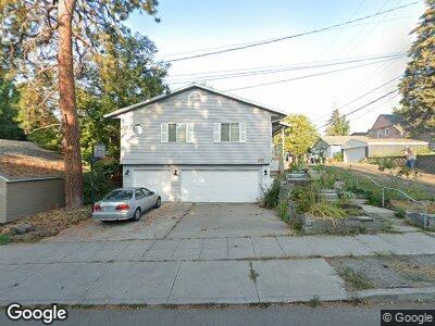
1010 S Elm St Spokane, WA 99204
Cliff-Cannon NeighborhoodEstimated Value: $531,116 - $663,000
4
Beds
4
Baths
2,515
Sq Ft
$235/Sq Ft
Est. Value
About This Home
This home is located at 1010 S Elm St, Spokane, WA 99204 and is currently estimated at $591,529, approximately $235 per square foot. 1010 S Elm St is a home located in Spokane County with nearby schools including Roosevelt Elementary School, Sacajawea Middle School, and Lewis & Clark High School.
Ownership History
Date
Name
Owned For
Owner Type
Purchase Details
Closed on
Dec 19, 2005
Sold by
Hoffman Edward A
Bought by
Mellinger Karla
Current Estimated Value
Home Financials for this Owner
Home Financials are based on the most recent Mortgage that was taken out on this home.
Original Mortgage
$220,500
Interest Rate
7.62%
Mortgage Type
Purchase Money Mortgage
Purchase Details
Closed on
Mar 16, 1998
Sold by
Barnard J Kimball and Barnard Sheri
Bought by
Hoffman Edward A
Home Financials for this Owner
Home Financials are based on the most recent Mortgage that was taken out on this home.
Original Mortgage
$144,000
Interest Rate
7.15%
Mortgage Type
Construction
Create a Home Valuation Report for This Property
The Home Valuation Report is an in-depth analysis detailing your home's value as well as a comparison with similar homes in the area
Home Values in the Area
Average Home Value in this Area
Purchase History
| Date | Buyer | Sale Price | Title Company |
|---|---|---|---|
| Mellinger Karla | $245,000 | First American Title Ins | |
| Hoffman Edward A | $3,801 | Pioneer Title Company | |
| Hoffman Edward A | -- | Pioneer Title Company |
Source: Public Records
Mortgage History
| Date | Status | Borrower | Loan Amount |
|---|---|---|---|
| Open | Mellinger Karla | $125,000 | |
| Closed | Mellinger Karla | $90,000 | |
| Closed | Mellinger Karla E | $40,000 | |
| Closed | Mellinger Karla | $220,500 | |
| Previous Owner | Hoffman Edward A | $144,000 |
Source: Public Records
Tax History Compared to Growth
Tax History
| Year | Tax Paid | Tax Assessment Tax Assessment Total Assessment is a certain percentage of the fair market value that is determined by local assessors to be the total taxable value of land and additions on the property. | Land | Improvement |
|---|---|---|---|---|
| 2024 | $5,011 | $505,300 | $80,000 | $425,300 |
| 2023 | $4,939 | $505,300 | $80,000 | $425,300 |
| 2022 | $4,543 | $505,300 | $80,000 | $425,300 |
| 2021 | $4,144 | $348,600 | $38,000 | $310,600 |
| 2020 | $3,791 | $307,200 | $35,000 | $272,200 |
| 2019 | $3,540 | $296,200 | $35,000 | $261,200 |
| 2018 | $3,395 | $244,100 | $30,000 | $214,100 |
| 2017 | $3,071 | $224,800 | $30,000 | $194,800 |
| 2016 | $2,911 | $208,500 | $30,000 | $178,500 |
| 2015 | $2,807 | $196,700 | $30,000 | $166,700 |
| 2014 | -- | $226,300 | $30,000 | $196,300 |
| 2013 | -- | $0 | $0 | $0 |
Source: Public Records
Map
Nearby Homes
- 2003 W 10th Ave
- 1903 W 9th Ave
- 1733 W 10th Ave
- 2015 W 9th Ave
- 2011 W 9th Ave
- 1126 S Coeur D'Alene St Unit S1126
- 1126 S Coeur D'Alene St
- 1728 W 9th Ave
- 1914 W 8th Ave
- 2002 W 8th Ave
- 1818 W 8th Ave
- 1746 W 14th Ave
- 2020 7th Ave
- 1607 W 11th Ave
- 1310 S Ash St
- 1619 W 8th Ave
- 1711 W 7th Ave Unit 302
- 1627 W 7th Ave
- 1841 W 15th Ave
- 820 S Walnut St
- 1010 S Elm St
- 1906 W 11th Ave
- 1916 W 11th Ave
- 1903 W 10th Ave
- 1915 W 10th Ave
- 1911 W 10th Ave
- 1822 W 11th Ave
- 1920 W 11th Ave
- 1820 W 11th Ave
- 1005 S Elm St
- 1919 W 10th Ave
- 1924 W 11th Ave
- 1104 S Elm St
- 1909 W 11th Ave
- 1814 W 11th Ave
- 1815 W 10th Ave
- 1921 W 10th Ave
- 1917 W 11th Ave
- 1810 W 11th Ave
- 1821 W 11th Ave