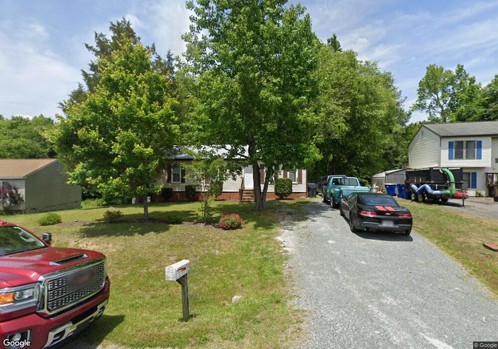
10118 Alberta Cir Chesterfield, VA 23832
Estimated Value: $283,000 - $310,000
3
Beds
2
Baths
1,074
Sq Ft
$275/Sq Ft
Est. Value
About This Home
This home is located at 10118 Alberta Cir, Chesterfield, VA 23832 and is currently estimated at $295,488, approximately $275 per square foot. 10118 Alberta Cir is a home located in Chesterfield County with nearby schools including Thelma Crenshaw Elementary School, Bailey Bridge Middle School, and Manchester High.
Ownership History
Date
Name
Owned For
Owner Type
Purchase Details
Closed on
Nov 28, 2023
Sold by
Lessig Carol L and Lessig Richard W
Bought by
Lessig Richard W and Lessig Carol J
Current Estimated Value
Purchase Details
Closed on
Oct 26, 2005
Sold by
Webb Jerry L
Bought by
Lessig Carol J
Create a Home Valuation Report for This Property
The Home Valuation Report is an in-depth analysis detailing your home's value as well as a comparison with similar homes in the area
Home Values in the Area
Average Home Value in this Area
Purchase History
| Date | Buyer | Sale Price | Title Company |
|---|---|---|---|
| Lessig Richard W | -- | None Listed On Document | |
| Lessig Richard W | -- | None Listed On Document | |
| Lessig Carol J | $80,000 | -- |
Source: Public Records
Tax History Compared to Growth
Tax History
| Year | Tax Paid | Tax Assessment Tax Assessment Total Assessment is a certain percentage of the fair market value that is determined by local assessors to be the total taxable value of land and additions on the property. | Land | Improvement |
|---|---|---|---|---|
| 2025 | $2,238 | $248,600 | $60,000 | $188,600 |
| 2024 | $2,238 | $227,300 | $52,000 | $175,300 |
| 2023 | $1,978 | $217,400 | $49,000 | $168,400 |
| 2022 | $1,826 | $198,500 | $47,000 | $151,500 |
| 2021 | $1,704 | $176,700 | $45,000 | $131,700 |
| 2020 | $1,537 | $161,800 | $45,000 | $116,800 |
| 2019 | $1,489 | $156,700 | $42,000 | $114,700 |
| 2018 | $1,389 | $146,200 | $42,000 | $104,200 |
| 2017 | $1,320 | $137,500 | $42,000 | $95,500 |
| 2016 | $1,240 | $129,200 | $42,000 | $87,200 |
| 2015 | $1,171 | $122,000 | $42,000 | $80,000 |
| 2014 | $1,123 | $117,000 | $40,000 | $77,000 |
Source: Public Records
Map
Nearby Homes
- 5101 Blossomwood Cir
- 11261 Sunfield Dr
- 10810 Ridgerun Rd
- 5324 Sandy Ridge Ct
- 5213 Oakforest Dr
- 5124 Rollingway Rd
- 5430 Solaris Dr
- 4519 Bexwood Dr
- 10508 Rollingway Ct
- 4706 Parrish Branch Rd
- 11701 Clear Ridge Dr
- 11425 Brandenburg Dr
- 4917 Bailey Woods Ln
- 10524 Sunne Ct
- The Rosewood Plan at Cosby Estates
- The Dogwood Plan at Cosby Estates
- The Bradford Plan at Cosby Estates
- The Magnolia Plan at Cosby Estates
- The Busch Plan at Cosby Estates
- The Portsmouth Plan at Cosby Estates
- 10112 Alberta Cir
- 10124 Alberta Cir
- 10106 Alberta Cir
- 10130 Alberta Cir
- 10119 Alberta Cir
- 10113 Alberta Cir
- 10125 Alberta Cir
- 10136 Alberta Cir
- 4918 Alberta Rd
- 4912 Alberta Rd
- 5000 Alberta Rd
- 10131 Alberta Cir
- 4906 Alberta Rd
- 5006 Alberta Rd
- 10137 Alberta Cir
- 10138 Alberta Cir
- 4919 Alberta Rd
- 4900 Alberta Rd
- 5001 Alberta Rd
- 4913 Alberta Rd