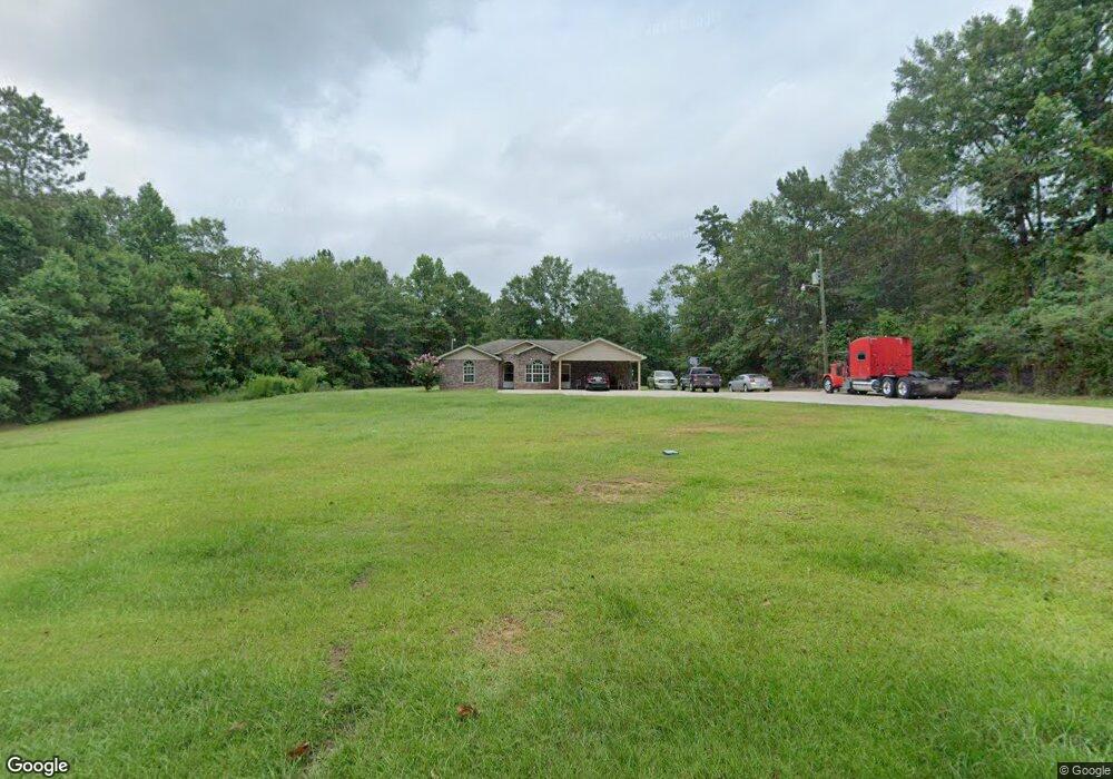
1014 Berthadale Rd McComb, MS 39648
Estimated Value: $180,000 - $251,551
Studio
1
Bath
1,981
Sq Ft
$108/Sq Ft
Est. Value
About This Home
This home is located at 1014 Berthadale Rd, McComb, MS 39648 and is currently estimated at $214,138, approximately $108 per square foot. 1014 Berthadale Rd is a home with nearby schools including Eva Gordon Lower Elementary School, Osyka Elementary School, and South Pike Junior High School.
Ownership History
Date
Name
Owned For
Owner Type
Purchase Details
Closed on
Sep 22, 2010
Sold by
Wilds And Blossman Llc
Bought by
Coney Evorjia L
Current Estimated Value
Home Financials for this Owner
Home Financials are based on the most recent Mortgage that was taken out on this home.
Original Mortgage
$188,000
Outstanding Balance
$133,886
Interest Rate
4.45%
Mortgage Type
USDA
Estimated Equity
$80,252
Create a Home Valuation Report for This Property
The Home Valuation Report is an in-depth analysis detailing your home's value as well as a comparison with similar homes in the area
Purchase History
| Date | Buyer | Sale Price | Title Company |
|---|---|---|---|
| Coney Evorjia L | -- | None Available | |
| Coney Evorjia L | -- | None Available |
Source: Public Records
Mortgage History
| Date | Status | Borrower | Loan Amount |
|---|---|---|---|
| Open | Coney Evorjia L | $188,000 | |
| Closed | Coney Evorjia L | $188,000 |
Source: Public Records
Tax History
| Year | Tax Paid | Tax Assessment Tax Assessment Total Assessment is a certain percentage of the fair market value that is determined by local assessors to be the total taxable value of land and additions on the property. | Land | Improvement |
|---|---|---|---|---|
| 2025 | $1,511 | $14,457 | $0 | $0 |
| 2024 | $1,282 | $12,286 | $0 | $0 |
| 2023 | $1,233 | $12,286 | $0 | $0 |
| 2022 | $1,216 | $12,286 | $0 | $0 |
| 2021 | $1,164 | $12,286 | $0 | $0 |
| 2020 | $1,208 | $12,358 | $0 | $0 |
| 2019 | $1,181 | $12,358 | $0 | $0 |
| 2018 | $1,149 | $12,358 | $0 | $0 |
| 2017 | $1,171 | $12,358 | $0 | $0 |
| 2016 | $1,171 | $12,358 | $0 | $0 |
| 2015 | -- | $11,908 | $0 | $0 |
| 2014 | -- | $11,909 | $0 | $0 |
| 2013 | -- | $11,909 | $0 | $0 |
Source: Public Records
Map
Nearby Homes
- X Wild Estate
- 2159 Oakdale Rd
- 0 Old 24 Hwy
- 1047 Lenoir Sellers Rd
- XXX US Highway 98
- 7153 US Highway 98
- 00 US Highway 98
- 480 Universal St
- ... Berkshire Ln
- 1002 Pershing St
- ... W Presley Blvd
- 4019 E Fernwood Rd
- 3092 Airport Fernwood Rd
- 0 Morgantown Rd Unit 4125975
- 823 Edgar St
- No Integrity Rd
- 0 Integrity Rd
- 429 21st St
- 214 Thompson St
- 425 S Broadway St
- 2139 Old Industrial Rd
- 1028 Berthadale Rd
- 2145 Old Industrial Rd
- 2151 Old Industrial Rd
- 1026 Wild Estate
- Lot #5 Wild Estate
- 00 Wild Estate
- Lot #6 Wild Estate
- Lot #7 Wild Estate
- Lot #8 Wild Estate
- 0 Wild Estate
- 2127 Old Industrial Rd
- 1021 Wild Estate
- 2115 Old Industrial Rd
- 1025 Wild Estate
- 2115 Old Industrial Rd
- 1011 Wild Estate
- 1035 Wild Estate
- 1046 Wild Estate
- 1062 Berthadale Rd
Your Personal Tour Guide
Ask me questions while you tour the home.