Estimated Value: $574,000 - $738,000
4
Beds
3
Baths
2,266
Sq Ft
$305/Sq Ft
Est. Value
About This Home
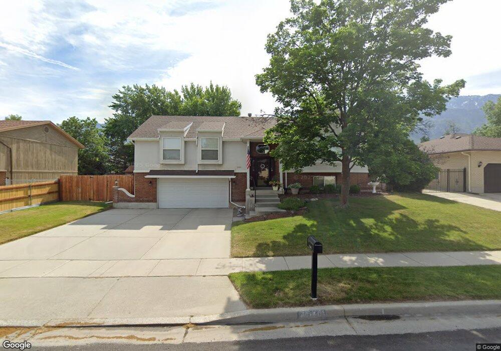
This home is located at 10141 S 2165 E, Sandy, UT 84092 and is currently estimated at $690,969, approximately $304 per square foot. 10141 S 2165 E is a home located in Salt Lake County with nearby schools including Park Lane Elementary School, Eastmont Middle School, and Jordan High.
Ownership History
Date
Name
Owned For
Owner Type
Purchase Details
Closed on
May 28, 2021
Sold by
Boice Todd and Estate Of Raymond J Boice
Bought by
Kemp Krista E
Current Estimated Value
Home Financials for this Owner
Home Financials are based on the most recent Mortgage that was taken out on this home.
Original Mortgage
$325,000
Outstanding Balance
$294,247
Interest Rate
2.9%
Mortgage Type
New Conventional
Estimated Equity
$396,722
Purchase Details
Closed on
Sep 17, 2020
Sold by
Boice Raymond J and Boice Joyce E
Bought by
Boice Raymond J
Home Financials for this Owner
Home Financials are based on the most recent Mortgage that was taken out on this home.
Original Mortgage
$111,000
Interest Rate
2.9%
Mortgage Type
New Conventional
Purchase Details
Closed on
Jul 18, 1995
Sold by
Thompson Kenneth S and Thompson Nancy J
Bought by
Boice Raymond J and Boice Joyce E
Home Financials for this Owner
Home Financials are based on the most recent Mortgage that was taken out on this home.
Original Mortgage
$143,100
Interest Rate
7.59%
Create a Home Valuation Report for This Property
The Home Valuation Report is an in-depth analysis detailing your home's value as well as a comparison with similar homes in the area
Home Values in the Area
Average Home Value in this Area
Purchase History
| Date | Buyer | Sale Price | Title Company |
|---|---|---|---|
| Kemp Krista E | -- | Title Guarantee Sandy | |
| Boice Raymond J | -- | Title 365 | |
| Boice Raymond J | -- | None Listed On Document | |
| Boice Raymond J | -- | Backman Stewart Title Servic |
Source: Public Records
Mortgage History
| Date | Status | Borrower | Loan Amount |
|---|---|---|---|
| Open | Kemp Krista E | $325,000 | |
| Previous Owner | Boice Raymond J | $111,000 | |
| Previous Owner | Boice Raymond J | $143,100 |
Source: Public Records
Tax History
| Year | Tax Paid | Tax Assessment Tax Assessment Total Assessment is a certain percentage of the fair market value that is determined by local assessors to be the total taxable value of land and additions on the property. | Land | Improvement |
|---|---|---|---|---|
| 2025 | $3,603 | $696,700 | $303,000 | $393,700 |
| 2024 | $3,603 | $675,300 | $291,700 | $383,600 |
| 2023 | $3,603 | $638,600 | $280,500 | $358,100 |
| 2022 | $3,509 | $645,800 | $275,000 | $370,800 |
| 2021 | $2,713 | $425,100 | $220,000 | $205,100 |
| 2020 | $2,569 | $379,900 | $220,000 | $159,900 |
| 2019 | $2,513 | $362,500 | $210,300 | $152,200 |
| 2018 | $2,019 | $304,600 | $210,300 | $94,300 |
| 2017 | $1,922 | $277,400 | $210,300 | $67,100 |
| 2016 | $1,856 | $258,900 | $189,500 | $69,400 |
| 2015 | $2,160 | $279,400 | $200,900 | $78,500 |
| 2014 | $2,095 | $266,200 | $195,200 | $71,000 |
Source: Public Records
Map
Nearby Homes
- 2009 E Sweetbriar Ln
- 2170 E Borg Ct
- 2163 E Borg Dr
- 9942 S Altamont Dr
- 1952 E Bluffside Cir
- 9650 S Buttonwood Dr
- 2015 E Dimple Dell Rd
- 10665 S 2340 E
- 9969 Altamont Dr
- 2342 Charros Rd
- 9525 S Carriage Chase Ln
- 10158 Buttercup Dr
- 2026 E 10765 S
- 1602 E Sego Lily Dr
- 9979 S Albury Rd
- 1650 E Budding Dr
- 9472 Fox Hunt Dr
- 10240 Locksley Rd
- 9971 Pinehurst Dr
- 2724 Mount Jordan Rd
- 10129 S 2165 E
- 10155 S 2165 E
- 10144 S Kalinda Dr
- 10156 Kalinda Dr
- 10150 S 2165 E
- 2177 E Karalee Way
- 10117 S 2165 E
- 10136 S 2165 E
- 10170 Kalinda Dr
- 10170 S Kalinda Dr
- 10164 S 2165 E Unit 2165
- 10118 Kalinda Dr
- 2177 Karalee Way
- 10122 S 2165 E
- 10105 S 2165 E
- 10143 S 2130 E
- 10153 S Kalinda Dr
- 10153 Kalinda Dr
- 10178 S 2165 E
- 10131 S 2130 E
Your Personal Tour Guide
Ask me questions while you tour the home.