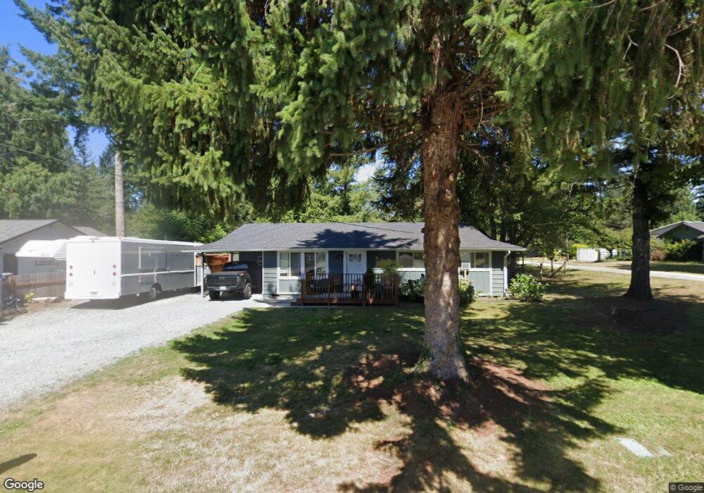
1015 Dyer Rd Sultan, WA 98294
Estimated Value: $400,000 - $487,000
3
Beds
1
Bath
1,066
Sq Ft
$425/Sq Ft
Est. Value
About This Home
This home is located at 1015 Dyer Rd, Sultan, WA 98294 and is currently estimated at $453,445, approximately $425 per square foot. 1015 Dyer Rd is a home located in Snohomish County with nearby schools including Sultan Senior High School.
Ownership History
Date
Name
Owned For
Owner Type
Purchase Details
Closed on
Apr 3, 2017
Sold by
Real Property Funding Group Llc
Bought by
Roosevelt Holdings Llc
Current Estimated Value
Purchase Details
Closed on
Mar 31, 2017
Sold by
Effenburger Mark
Bought by
Real Property Funding Group Llc
Purchase Details
Closed on
Nov 5, 1997
Sold by
Braley Jefferey Alan and Braley Sandra Lea
Bought by
Effenberger Elaine M
Home Financials for this Owner
Home Financials are based on the most recent Mortgage that was taken out on this home.
Original Mortgage
$83,500
Interest Rate
7.26%
Create a Home Valuation Report for This Property
The Home Valuation Report is an in-depth analysis detailing your home's value as well as a comparison with similar homes in the area
Home Values in the Area
Average Home Value in this Area
Purchase History
| Date | Buyer | Sale Price | Title Company |
|---|---|---|---|
| Roosevelt Holdings Llc | -- | None Available | |
| Real Property Funding Group Llc | $128,756 | Stewart Title | |
| Effenberger Elaine M | $113,500 | Old Republic Title Ltd |
Source: Public Records
Mortgage History
| Date | Status | Borrower | Loan Amount |
|---|---|---|---|
| Previous Owner | Effenberger Elaine M | $83,500 |
Source: Public Records
Tax History
| Year | Tax Paid | Tax Assessment Tax Assessment Total Assessment is a certain percentage of the fair market value that is determined by local assessors to be the total taxable value of land and additions on the property. | Land | Improvement |
|---|---|---|---|---|
| 2026 | $3,222 | $384,000 | $239,000 | $145,000 |
| 2025 | $3,115 | $359,300 | $195,000 | $164,300 |
| 2024 | $3,115 | $350,500 | $192,000 | $158,500 |
| 2023 | $2,531 | $322,100 | $219,000 | $103,100 |
| 2022 | $2,176 | $237,800 | $162,000 | $75,800 |
| 2020 | $1,909 | $189,600 | $136,000 | $53,600 |
| 2019 | $1,612 | $166,400 | $116,000 | $50,400 |
| 2018 | $1,736 | $145,200 | $97,000 | $48,200 |
| 2017 | $1,927 | $159,800 | $92,000 | $67,800 |
| 2016 | $1,618 | $131,200 | $66,000 | $65,200 |
| 2015 | $1,504 | $114,200 | $51,000 | $63,200 |
| 2013 | $1,287 | $95,000 | $40,000 | $55,000 |
Source: Public Records
Map
Nearby Homes
- 1122 Dyer Rd
- 712 Alder St
- 512 Walnut Ave
- 307 8th St Unit 7
- 711 10th St
- 924 Merea Ln
- 0 138th St SE
- 1105 Kessler Dr
- 204 Date Ave
- 1107 Loves Hill Dr
- 14055 Sultan Basin Rd
- 111 Cedar Ave Unit 1
- 712 3rd St
- 32302 135th Place SE
- 32306 135th Place SE
- 13435 323rd Dr SE
- 13434 323rd Ave SE
- 13431 323rd Dr SE
- 13430 323rd Ave SE
- 13426 323rd Ave SE
Your Personal Tour Guide
Ask me questions while you tour the home.