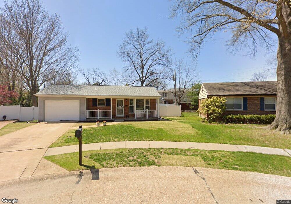
1017 Brooksgate Manor Dr Saint Louis, MO 63122
Estimated Value: $257,898 - $289,000
2
Beds
2
Baths
1,254
Sq Ft
$218/Sq Ft
Est. Value
About This Home
This home is located at 1017 Brooksgate Manor Dr, Saint Louis, MO 63122 and is currently estimated at $273,475, approximately $218 per square foot. 1017 Brooksgate Manor Dr is a home located in St. Louis County with nearby schools including George R. Robinson Elementary School, Nipher Middle School, and Kirkwood Senior High School.
Ownership History
Date
Name
Owned For
Owner Type
Purchase Details
Closed on
Nov 27, 2012
Sold by
Cronin Donna and Cordonnier Justin
Bought by
Benson Luray E and The David M Benson & Luray E Benson Trus
Current Estimated Value
Purchase Details
Closed on
May 29, 2012
Sold by
Mcgraw Gerald
Bought by
Cronin Donna and Cordonnier Justin
Home Financials for this Owner
Home Financials are based on the most recent Mortgage that was taken out on this home.
Original Mortgage
$84,375
Interest Rate
3.86%
Mortgage Type
New Conventional
Create a Home Valuation Report for This Property
The Home Valuation Report is an in-depth analysis detailing your home's value as well as a comparison with similar homes in the area
Home Values in the Area
Average Home Value in this Area
Purchase History
| Date | Buyer | Sale Price | Title Company |
|---|---|---|---|
| Benson Luray E | $178,000 | Us Title Main | |
| Cronin Donna | $112,500 | Us Title Main |
Source: Public Records
Mortgage History
| Date | Status | Borrower | Loan Amount |
|---|---|---|---|
| Previous Owner | Cronin Donna | $84,375 |
Source: Public Records
Tax History
| Year | Tax Paid | Tax Assessment Tax Assessment Total Assessment is a certain percentage of the fair market value that is determined by local assessors to be the total taxable value of land and additions on the property. | Land | Improvement |
|---|---|---|---|---|
| 2025 | $2,839 | $47,430 | $12,050 | $35,380 |
| 2024 | $2,839 | $45,070 | $9,650 | $35,420 |
| 2023 | $2,795 | $45,070 | $9,650 | $35,420 |
| 2022 | $3,051 | $42,450 | $10,850 | $31,600 |
| 2021 | $2,760 | $42,450 | $10,850 | $31,600 |
| 2020 | $2,503 | $36,990 | $6,020 | $30,970 |
| 2019 | $2,529 | $36,990 | $6,020 | $30,970 |
| 2018 | $2,350 | $30,340 | $3,610 | $26,730 |
| 2017 | $2,347 | $30,340 | $3,610 | $26,730 |
| 2016 | $2,105 | $27,380 | $4,830 | $22,550 |
Source: Public Records
Map
Nearby Homes
- 1140 S Geyer Rd
- 635 Maple Forest Unit 24
- 420 W Rose Hill Ave
- 338 W Rose Hill Ave
- 233 Midway Ave
- 1016 Forest Ave
- 36 Orchard Ln
- 1059 Huthmaker Ave
- 621 S Kirkwood Rd Unit 202
- 667 S Kirkwood Rd Unit 102
- 630 Candleberry Ct Unit D
- 540 Hickory Hollow Ln
- 524 Hickory Hollow Ln
- 1494 Royal Springs Dr
- 621 Crest Ct
- 425 S Geyer Rd Unit G
- 522 Nirk Ave Unit I
- 530 Nirk Ave Unit G
- 9 Lemp Rd
- 709 S Fillmore Ave
- 1015 Brooksgate Manor Dr
- 1054 Brooksgate Manor Dr
- 1052 Brooksgate Manor Dr
- 1044 Brooksgate Manor Dr
- 1046 Brooksgate Manor Dr
- 1048 Brooksgate Manor Dr
- 1070 Brooksgate Manor Dr
- 1056 Brooksgate Manor Dr
- 1058 Brooksgate Manor Dr
- 1042 Brooksgate Manor Dr
- 1023 Brooksgate Manor Dr
- 1003 Brooksgate Manor Dr
- 1034 Brooksgate Manor Dr
- 1032 Brooksgate Manor Dr
- 1068 Brooksgate Manor Dr
- 1038 Brooksgate Manor Dr
- 1036 Brooksgate Manor Dr
- 1064 Brooksgate Manor Dr
- 1066 Brooksgate Manor Dr
Your Personal Tour Guide
Ask me questions while you tour the home.