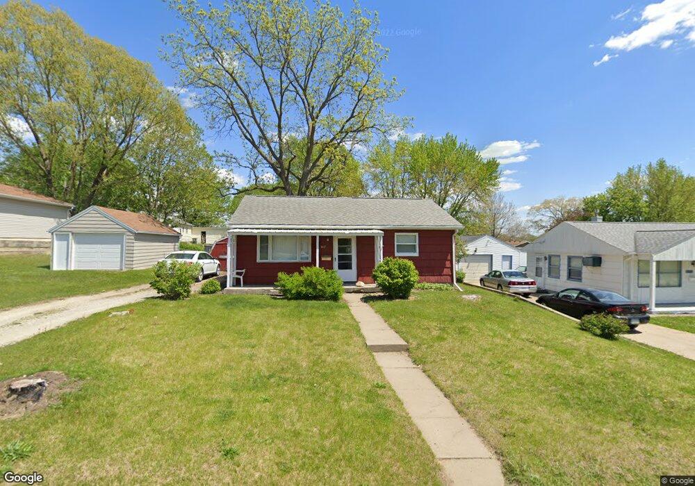
1017 Littlefield Rd Waterloo, IA 50701
Alabar Hills NeighborhoodEstimated Value: $95,416 - $117,000
2
Beds
1
Bath
768
Sq Ft
$138/Sq Ft
Est. Value
About This Home
This home is located at 1017 Littlefield Rd, Waterloo, IA 50701 and is currently estimated at $105,854, approximately $137 per square foot. 1017 Littlefield Rd is a home located in Black Hawk County with nearby schools including Becker Elementary School, Central Middle School, and West High School.
Ownership History
Date
Name
Owned For
Owner Type
Purchase Details
Closed on
Dec 18, 2014
Sold by
Burman Steve
Bought by
Traetow Christopher L
Current Estimated Value
Home Financials for this Owner
Home Financials are based on the most recent Mortgage that was taken out on this home.
Original Mortgage
$40,800
Outstanding Balance
$31,333
Interest Rate
3.99%
Mortgage Type
Credit Line Revolving
Estimated Equity
$74,521
Create a Home Valuation Report for This Property
The Home Valuation Report is an in-depth analysis detailing your home's value as well as a comparison with similar homes in the area
Home Values in the Area
Average Home Value in this Area
Purchase History
| Date | Buyer | Sale Price | Title Company |
|---|---|---|---|
| Traetow Christopher L | $51,000 | Black Hawk County Abstract & |
Source: Public Records
Mortgage History
| Date | Status | Borrower | Loan Amount |
|---|---|---|---|
| Open | Traetow Christopher L | $40,800 |
Source: Public Records
Tax History
| Year | Tax Paid | Tax Assessment Tax Assessment Total Assessment is a certain percentage of the fair market value that is determined by local assessors to be the total taxable value of land and additions on the property. | Land | Improvement |
|---|---|---|---|---|
| 2025 | $1,854 | $93,550 | $15,430 | $78,120 |
| 2024 | $1,854 | $85,480 | $15,430 | $70,050 |
| 2023 | $1,642 | $85,480 | $15,430 | $70,050 |
| 2022 | $1,598 | $74,740 | $15,430 | $59,310 |
| 2021 | $1,538 | $74,740 | $15,430 | $59,310 |
| 2020 | $1,514 | $67,920 | $15,430 | $52,490 |
| 2019 | $1,514 | $67,920 | $15,430 | $52,490 |
| 2018 | $1,514 | $67,920 | $15,430 | $52,490 |
| 2017 | $1,560 | $67,920 | $15,430 | $52,490 |
| 2016 | $1,540 | $67,920 | $15,430 | $52,490 |
| 2015 | $1,540 | $67,920 | $15,430 | $52,490 |
| 2014 | $1,370 | $67,920 | $15,430 | $52,490 |
Source: Public Records
Map
Nearby Homes
- 1811 Sager Ave
- 819 Hanna Blvd
- 1114 Eleanor Dr
- 1221 Julian Ave
- 600 Beverly Hills St
- 1290 Scott Ave
- 1839 Rush St
- 1906 Coachman Dr
- 1221 Downing Ave
- 425 Auburn St
- 412 Hughes Dr
- 320 Valley Rd
- 2320 University Ave
- 1044 Dundee Ave
- 0 Bergen Dr
- 645 Dundee Ave
- 211 Auburn St
- 627 Downing Ave
- 124 Axlewood Dr
- 118 Axlewood Dr
- 1025 Littlefield Rd
- 1001 Littlefield Rd
- 1701 Flower St
- 1031 Littlefield Rd
- 916 Alabar Ave
- 1700 Corning Ave
- 1715 Flower St
- 1037 Littlefield Rd
- 940 Littlefield Rd
- 924 Alabar Ave
- 1714 Corning Ave
- 1018 Linbud Ln
- 934 Littlefield Rd
- 901 Alabar Ave
- 1727 Flower St
- 1726 Corning Ave
- 1701 Corning Ave
- 1024 Linbud Ln
- 1709 Corning Ave
- 909 Alabar Ave
Your Personal Tour Guide
Ask me questions while you tour the home.