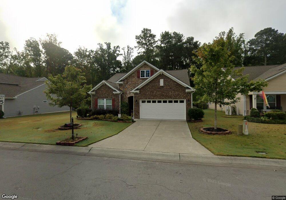
1019 Poplar St Durham, NC 27703
Eastern Durham NeighborhoodEstimated Value: $459,000 - $512,000
3
Beds
2
Baths
2,117
Sq Ft
$228/Sq Ft
Est. Value
About This Home
This home is located at 1019 Poplar St, Durham, NC 27703 and is currently estimated at $482,499, approximately $227 per square foot. 1019 Poplar St is a home located in Durham County with nearby schools including Spring Valley Elementary School, John W Neal Middle School, and Southern School of Energy & Sustainability.
Ownership History
Date
Name
Owned For
Owner Type
Purchase Details
Closed on
Sep 8, 2016
Sold by
Tanabe Paula J
Bought by
Tanabe Mark R and Tanabe Paula
Current Estimated Value
Home Financials for this Owner
Home Financials are based on the most recent Mortgage that was taken out on this home.
Original Mortgage
$88,927
Interest Rate
3.48%
Mortgage Type
New Conventional
Purchase Details
Closed on
Jul 28, 2016
Sold by
Calatlantic Grp Inc
Bought by
Tanabe Paula J and Tanabe Mark R
Home Financials for this Owner
Home Financials are based on the most recent Mortgage that was taken out on this home.
Original Mortgage
$88,927
Interest Rate
3.48%
Mortgage Type
New Conventional
Create a Home Valuation Report for This Property
The Home Valuation Report is an in-depth analysis detailing your home's value as well as a comparison with similar homes in the area
Home Values in the Area
Average Home Value in this Area
Purchase History
| Date | Buyer | Sale Price | Title Company |
|---|---|---|---|
| Tanabe Mark R | -- | -- | |
| Tanabe Paula J | $291,000 | -- |
Source: Public Records
Mortgage History
| Date | Status | Borrower | Loan Amount |
|---|---|---|---|
| Previous Owner | Tanabe Paula J | $88,927 |
Source: Public Records
Tax History Compared to Growth
Tax History
| Year | Tax Paid | Tax Assessment Tax Assessment Total Assessment is a certain percentage of the fair market value that is determined by local assessors to be the total taxable value of land and additions on the property. | Land | Improvement |
|---|---|---|---|---|
| 2025 | $4,591 | $463,116 | $103,250 | $359,866 |
| 2024 | $3,829 | $274,529 | $53,055 | $221,474 |
| 2023 | $3,596 | $274,529 | $53,055 | $221,474 |
| 2022 | $3,514 | $274,529 | $53,055 | $221,474 |
| 2021 | $3,497 | $274,529 | $53,055 | $221,474 |
| 2020 | $3,415 | $274,529 | $53,055 | $221,474 |
| 2019 | $3,415 | $274,529 | $53,055 | $221,474 |
| 2018 | $3,060 | $225,566 | $47,160 | $178,406 |
| 2017 | $3,037 | $225,566 | $47,160 | $178,406 |
| 2016 | $614 | $47,160 | $47,160 | $0 |
| 2015 | $63 | $4,550 | $4,550 | $0 |
| 2014 | $63 | $4,550 | $4,550 | $0 |
Source: Public Records
Map
Nearby Homes
- 814 Poplar St
- 1020 Big Spring Cir
- 1305 San Antonio Blvd
- 6 Dawson Ct
- 1106 Constellation Cir
- 1102 Constellation Cir
- 3338 Prospect Pkwy
- 632 Poplar St
- 611 Poplar St
- Coleman Plan at Stella View - Ardmore Collection
- Tryon III Plan at Stella View - Summit Collection
- Mayflower III Plan at Stella View - Summit Collection
- Landrum III Plan at Stella View - Summit Collection
- 1307 Cosmic Dr
- 1017 Constellation Cir
- 2002 Cross Bones Blvd Unit 36
- 807 Outlaw Ave Unit 19
- 2011 Cross Bones Blvd Unit 41
- 1009 Shovelhead Dr Unit 5
- Galvani II Plan at Shaw Ridge