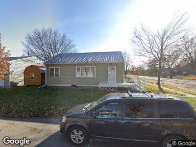
102 E Wilmans St Clarksville, IA 50619
Estimated Value: $166,000 - $262,000
3
Beds
1
Bath
864
Sq Ft
$228/Sq Ft
Est. Value
About This Home
This home is located at 102 E Wilmans St, Clarksville, IA 50619 and is currently estimated at $197,306, approximately $228 per square foot. 102 E Wilmans St is a home located in Butler County with nearby schools including Clarksville Elementary School and Clarksville High School.
Ownership History
Date
Name
Owned For
Owner Type
Purchase Details
Closed on
Jan 20, 2011
Sold by
Fokkena Holly A and Fokkena Habbo G
Bought by
Billington William
Current Estimated Value
Home Financials for this Owner
Home Financials are based on the most recent Mortgage that was taken out on this home.
Original Mortgage
$61,996
Interest Rate
4.84%
Mortgage Type
New Conventional
Create a Home Valuation Report for This Property
The Home Valuation Report is an in-depth analysis detailing your home's value as well as a comparison with similar homes in the area
Home Values in the Area
Average Home Value in this Area
Purchase History
| Date | Buyer | Sale Price | Title Company |
|---|---|---|---|
| Billington William | $60,000 | None Available |
Source: Public Records
Mortgage History
| Date | Status | Borrower | Loan Amount |
|---|---|---|---|
| Open | Billington William B | $108,000 | |
| Closed | Billington William Blake | $70,000 | |
| Closed | Billington William | $61,996 | |
| Previous Owner | Fokkena Holly A | $26,000 |
Source: Public Records
Tax History Compared to Growth
Tax History
| Year | Tax Paid | Tax Assessment Tax Assessment Total Assessment is a certain percentage of the fair market value that is determined by local assessors to be the total taxable value of land and additions on the property. | Land | Improvement |
|---|---|---|---|---|
| 2024 | $2,508 | $159,290 | $5,320 | $153,970 |
| 2023 | $2,412 | $159,290 | $5,320 | $153,970 |
| 2022 | $2,338 | $130,490 | $5,320 | $125,170 |
| 2021 | $1,868 | $129,140 | $5,320 | $123,820 |
| 2020 | $1,868 | $101,310 | $5,320 | $95,990 |
| 2019 | $1,754 | $93,000 | $5,320 | $95,990 |
| 2018 | $1,006 | $60,080 | $0 | $0 |
| 2017 | $1,036 | $60,080 | $0 | $0 |
| 2016 | $930 | $54,670 | $0 | $0 |
| 2015 | $930 | $51,750 | $0 | $0 |
| 2014 | $882 | $51,750 | $0 | $0 |
Source: Public Records
Map
Nearby Homes
- 309 S Mather St
- 303 W Greene St
- 403 W Greene St
- 215 N Church St
- 530 W Superior St Unit 1
- 0 180th St
- 21109 Woodridge Ln
- 21165 Woodbridge Ln
- 21269 Woodridge Ln
- 21273 Woodbridge Ln
- 33673 210th St
- 415 W Water St
- 123 W Water St
- 117 E Washington St
- 21161 Woodridge Ln
- 21164 Woodridge Ln
- 21250 Woodridge Ln
- 21146 Woodridge Ln
- LOT 1 and 2 Cherry St
- 136 Elliot Ave