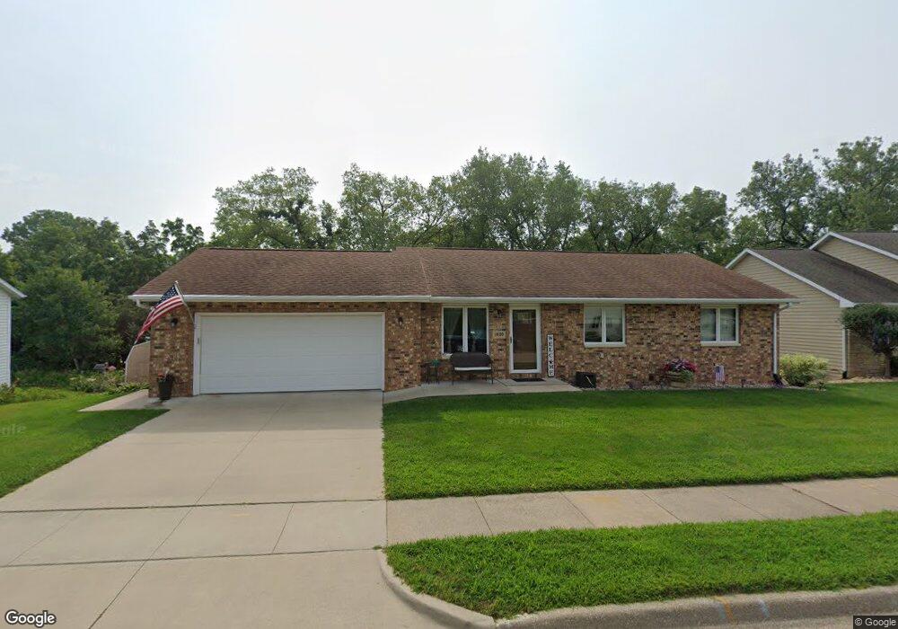
1020 Hawkeye Dr Dubuque, IA 52001
Estimated Value: $290,000 - $303,442
4
Beds
3
Baths
1,200
Sq Ft
$248/Sq Ft
Est. Value
About This Home
This home is located at 1020 Hawkeye Dr, Dubuque, IA 52001 and is currently estimated at $297,361, approximately $247 per square foot. 1020 Hawkeye Dr is a home located in Dubuque County with nearby schools including Marshall Elementary School, Thomas Jefferson Middle School, and Hempstead High School.
Ownership History
Date
Name
Owned For
Owner Type
Purchase Details
Closed on
Mar 21, 2005
Sold by
Baker Edward A and Baker Michelle M
Bought by
Harrison Terry E and Harrison Mary Ann
Current Estimated Value
Home Financials for this Owner
Home Financials are based on the most recent Mortgage that was taken out on this home.
Original Mortgage
$75,000
Interest Rate
5.64%
Mortgage Type
Purchase Money Mortgage
Create a Home Valuation Report for This Property
The Home Valuation Report is an in-depth analysis detailing your home's value as well as a comparison with similar homes in the area
Home Values in the Area
Average Home Value in this Area
Purchase History
| Date | Buyer | Sale Price | Title Company |
|---|---|---|---|
| Harrison Terry E | $145,500 | None Available |
Source: Public Records
Mortgage History
| Date | Status | Borrower | Loan Amount |
|---|---|---|---|
| Closed | Harrison Terry E | $75,000 |
Source: Public Records
Tax History Compared to Growth
Tax History
| Year | Tax Paid | Tax Assessment Tax Assessment Total Assessment is a certain percentage of the fair market value that is determined by local assessors to be the total taxable value of land and additions on the property. | Land | Improvement |
|---|---|---|---|---|
| 2025 | $3,610 | $286,300 | $38,900 | $247,400 |
| 2024 | $3,610 | $275,000 | $34,600 | $240,400 |
| 2023 | $3,596 | $275,000 | $34,600 | $240,400 |
| 2022 | $3,310 | $209,050 | $25,940 | $183,110 |
| 2021 | $3,310 | $209,050 | $25,940 | $183,110 |
| 2020 | $3,218 | $189,780 | $25,940 | $163,840 |
| 2019 | $3,238 | $189,780 | $25,940 | $163,840 |
| 2018 | $3,186 | $182,710 | $24,210 | $158,500 |
| 2017 | $3,036 | $182,710 | $24,210 | $158,500 |
| 2016 | $3,036 | $165,730 | $24,210 | $141,520 |
| 2015 | $2,970 | $165,730 | $24,210 | $141,520 |
| 2014 | $2,890 | $165,730 | $24,210 | $141,520 |
Source: Public Records
Map
Nearby Homes
- 931 Liberty Ave
- 3705 Aerostar Dr
- 920 Roosevelt St
- 3110 Burden St
- 495 Edith St
- 809 Goethe St
- 811 Lawther St
- 3400 Jackson St
- 2921 Balke St
- 1994 Golden Eagle Dr
- 1992 Golden Eagle Dr
- 2940 Elm St
- LOT 29 Sky Blue Dr
- 51 Milwaukee St
- 2934 Washington St
- 2035 Cobalt Ct
- Lot 1 Cobalt Ct Ct
- 2044 Sky Blue Dr
- 2069 Sky Blue Dr
- 2084 Sky Blue Dr
- 1000 Hawkeye Dr
- 1040 Hawkeye Dr
- 1025 Hawkeye Dr
- 3724 Buckeye Ct
- 990 Hawkeye Dr
- 1045 Hawkeye Dr
- 3744 Buckeye Ct
- 985 Hawkeye Dr
- 980 Hawkeye Dr
- 1060 Hawkeye Dr
- 3764 Buckeye Ct
- 760 Stone Ridge Place
- 762 Stone Ridge Place
- 764 Stone Ridge Place
- 975 Hawkeye Dr
- 766 Stone Ridge Place
- 809 Stone Ridge Place
- 805 Stone Ridge Place
- 813 Stone Ridge Place
- 811 Stone Ridge Place