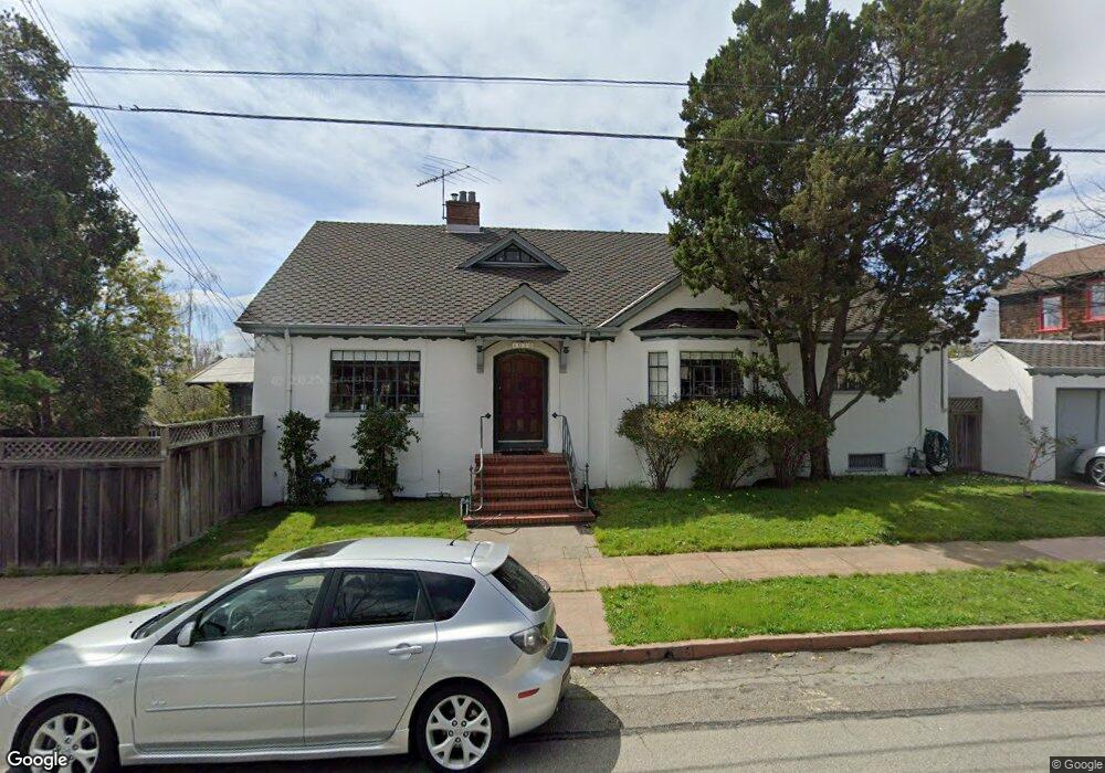
1020 Lassen St Berkeley, CA 94707
Northbrae NeighborhoodEstimated Value: $2,086,000 - $2,755,000
5
Beds
4
Baths
2,768
Sq Ft
$848/Sq Ft
Est. Value
About This Home
This home is located at 1020 Lassen St, Berkeley, CA 94707 and is currently estimated at $2,346,530, approximately $847 per square foot. 1020 Lassen St is a home located in Alameda County with nearby schools including Thousand Oaks Elementary School, Ruth Acty Elementary, and Berkeley Arts Magnet at Whittier School.
Ownership History
Date
Name
Owned For
Owner Type
Purchase Details
Closed on
Nov 30, 2001
Sold by
Curtis Sandra R
Bought by
Curtis Sandra R and Living Trust Of Sandra R Curti
Current Estimated Value
Purchase Details
Closed on
Jun 29, 2001
Sold by
Gertz John and Curtis Sandra R
Bought by
Curtis Sandra R
Create a Home Valuation Report for This Property
The Home Valuation Report is an in-depth analysis detailing your home's value as well as a comparison with similar homes in the area
Home Values in the Area
Average Home Value in this Area
Purchase History
| Date | Buyer | Sale Price | Title Company |
|---|---|---|---|
| Curtis Sandra R | -- | -- | |
| Curtis Sandra R | -- | -- | |
| Gertz John | -- | -- |
Source: Public Records
Tax History
| Year | Tax Paid | Tax Assessment Tax Assessment Total Assessment is a certain percentage of the fair market value that is determined by local assessors to be the total taxable value of land and additions on the property. | Land | Improvement |
|---|---|---|---|---|
| 2025 | $12,394 | $460,041 | $295,926 | $171,115 |
| 2024 | $12,394 | $450,885 | $290,124 | $167,761 |
| 2023 | $12,021 | $448,908 | $284,436 | $164,472 |
| 2022 | $11,617 | $433,106 | $278,859 | $161,247 |
| 2021 | $11,569 | $424,477 | $273,392 | $158,085 |
| 2020 | $10,637 | $427,053 | $270,588 | $156,465 |
| 2019 | $9,879 | $418,681 | $265,284 | $153,397 |
| 2018 | $9,632 | $410,473 | $260,083 | $150,390 |
| 2017 | $9,286 | $402,425 | $254,984 | $147,441 |
| 2016 | $8,758 | $394,536 | $249,985 | $144,551 |
| 2015 | $8,600 | $388,610 | $246,230 | $142,380 |
| 2014 | $8,395 | $380,999 | $241,408 | $139,591 |
Source: Public Records
Map
Nearby Homes
- 1950 Hopkins St
- 2121 Eunice St
- 826 Indian Rock Ave
- 813 San Diego Rd
- 1983 Yosemite Rd
- 1004 Cragmont Ave
- 1626 Hopkins St
- 765 San Diego Rd
- 1408 Henry St
- 2315 Eunice St
- 1425 Martin Luther King jr Way
- 1841 Vine St
- 758 Spruce St
- 1444 Walnut St
- 777 Cragmont Ave
- 1498 Sonoma Ave
- 753 Peralta Ave
- 962 Regal Rd
- 1515 Oxford St Unit 1D
- 1609 Bonita Ave Unit 5
- 1945 El Dorado Ave
- 1012 Lassen St
- 1941 El Dorado Ave
- 1955 El Dorado Ave
- 1935 El Dorado Ave
- 1959 El Dorado Ave
- 1011 Lassen St
- 1938 Marin Ave
- 1934 Marin Ave
- 1946 El Dorado Ave
- 1932 Marin Ave
- 1928 Monterey Ave
- 1942 El Dorado Ave
- 1950 El Dorado Ave
- 1926 Monterey Ave
- 1933 El Dorado Ave
- 1946 Marin Ave
- 1963 El Dorado Ave
- 1956 El Dorado Ave
- 1936 El Dorado Ave
Your Personal Tour Guide
Ask me questions while you tour the home.